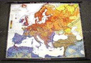
Wandkarte
Gerollte Schulwandkarte zur politischen Aufteilung der Welt vor dem 1. Weltkrieg
- Alternative title
-
Territoriale Aufteilung der Welt 1876-1914
- Location
-
Deutsches Historisches Museum, Berlin
- Inventory number
-
DG 90/8504
- Measurements
-
Höhe x Breite: 144 x 252 cm
- Material/Technique
-
Papier : Leinwand, Holz, gedruckt, aufgezogen
- Classification
-
Kartografie (Gattung)
- Subject (what)
-
Geschichte
Geographie
- Event
-
Herstellung
- (who)
-
Herausgeber: VEB Geografisch-Karthografische Anstalt
- (where)
-
Gotha, Deutschland [historisch: Deutsche Demokratische Republik]
- (when)
-
um 1970
- Rights
-
Deutsches Historisches Museum
- Last update
-
24.03.2023, 9:30 AM CET
Data provider
This object is provided by:
Stiftung Deutsches Historisches Museum. If you have any questions about the object, please contact the data provider.
Stiftung Deutsches Historisches Museum. If you have any questions about the object, please contact the data provider.
Object type
- Wandkarte
Associated
- Herausgeber: VEB Geografisch-Karthografische Anstalt
Time of origin
- um 1970
Other Objects (12)

Gerollte Schulwandkarte zur Geografie Osteuropas
Gerollte Schulwandkarte zur politischen Gliederung Europas im 19. Jahrhundert
Gerollte Schulwandkarte zur politischen Gliedrung der Welt um 1960
Gerollte Schulwandkarte zur politischen Gliederung der Welt um 1930
Gerollte Schulwandkarte zur Geografie der Sowjetunion
Gerollte Schulwandkarte zur Industrie und Landwirtschaft Europas
Gerollte Schulwandkarte zu den Rohstoffvorkommen in Mitteleuropa
Gerollte Schul-Wandkarte zur Illustration der nationalsozialistischen Rassentheorie
Gerollte Schulwandkarte zum Lebensstandard und zum Bildungsniveau der Weltbevölkerung
Gerollte Schulwandkarte zur administrativen Gliederung von Nord- und Mittelamerika
Gerollte Schulwandkarte aus der Sowjetunion zum Verlauf des 2. Weltkrieges
Gerollte Schulwandkarte aus der DDR zur europäischen Geschichte des 16. Jahrhunderts
Gerollte Schulwandkarte zur Geografie Osteuropas
Gerollte Schulwandkarte zur politischen Gliederung Europas im 19. Jahrhundert
Gerollte Schulwandkarte zur politischen Gliedrung der Welt um 1960
Gerollte Schulwandkarte zur politischen Gliederung der Welt um 1930
Gerollte Schulwandkarte zur Geografie der Sowjetunion
Gerollte Schulwandkarte zur Industrie und Landwirtschaft Europas
Gerollte Schulwandkarte zu den Rohstoffvorkommen in Mitteleuropa
Gerollte Schul-Wandkarte zur Illustration der nationalsozialistischen Rassentheorie
Gerollte Schulwandkarte zum Lebensstandard und zum Bildungsniveau der Weltbevölkerung
Gerollte Schulwandkarte zur administrativen Gliederung von Nord- und Mittelamerika
Gerollte Schulwandkarte aus der Sowjetunion zum Verlauf des 2. Weltkrieges