- Alternativer Titel
-
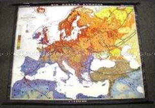
Osteuropa
- Standort
-
Deutsches Historisches Museum, Berlin
- Inventarnummer
-
DG 90/8508
- Maße
-
Höhe x Breite: 212 x 197 cm
- Material/Technik
-
Papier : Leinwand, Holz, gedruckt, aufgezogen
- Klassifikation
-
Kartografie (Gattung)
- Bezug (was)
-
Geographie
- Ereignis
-
Herstellung
- (wer)
-
Herausgeber: Justus Perthes
- (wo)
-
Gotha, Deutschland [historisch: Deutsche Demokratische Republik]
- (wann)
-
1951
- Rechteinformation
-
Deutsches Historisches Museum
- Letzte Aktualisierung
-
24.03.2023, 09:27 MEZ
Datenpartner
Dieses Objekt wird bereitgestellt von:
Stiftung Deutsches Historisches Museum. Bei Fragen zum Objekt wenden Sie sich bitte an den Datenpartner.
Stiftung Deutsches Historisches Museum. Bei Fragen zum Objekt wenden Sie sich bitte an den Datenpartner.
Objekttyp
- Wandkarte
Beteiligte
- Herausgeber: Justus Perthes
Entstanden
- 1951
Ähnliche Objekte (12)

Gerollte Schulwandkarte zur Industrie und Landwirtschaft Europas
Gerollte Schul-Wandkarte zur Illustration der nationalsozialistischen Rassentheorie
Gerollte Schulwandkarte zur politischen Gliederung Europas im 19. Jahrhundert
Gerollte Wandkarte zu den europäischen Vorkommen verschiedener Bodenschätze
Gerollte Wandkarte mit den politischen Einflussgebieten der Großmächte
Gerollte Schulwandkarte zur Geografie der Sowjetunion
Gerollte Schulwandkarte zu den Rohstoffvorkommen in Mitteleuropa
Gerollte Schulwandkarte zur administrativen Gliederung von Nord- und Mittelamerika
Gerollte Schulwandkarte zum Lebensstandard und zum Bildungsniveau der Weltbevölkerung
Gerollte Schulwandkarte zur politischen Gliedrung der Welt um 1960
Gerollte Schulwandkarte zur politischen Gliederung der Welt um 1930
Gerollte Schulwandkarte aus der Sowjetunion zum Verlauf des 2. Weltkrieges
Gerollte Schulwandkarte zur Industrie und Landwirtschaft Europas
Gerollte Schul-Wandkarte zur Illustration der nationalsozialistischen Rassentheorie
Gerollte Schulwandkarte zur politischen Gliederung Europas im 19. Jahrhundert
Gerollte Wandkarte zu den europäischen Vorkommen verschiedener Bodenschätze
Gerollte Wandkarte mit den politischen Einflussgebieten der Großmächte
Gerollte Schulwandkarte zur Geografie der Sowjetunion
Gerollte Schulwandkarte zu den Rohstoffvorkommen in Mitteleuropa
Gerollte Schulwandkarte zur administrativen Gliederung von Nord- und Mittelamerika
Gerollte Schulwandkarte zum Lebensstandard und zum Bildungsniveau der Weltbevölkerung
Gerollte Schulwandkarte zur politischen Gliedrung der Welt um 1960
Gerollte Schulwandkarte zur politischen Gliederung der Welt um 1930