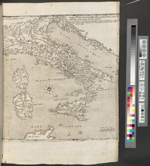
- Location
-
München, Bayerische Staatsbibliothek -- 2 Mapp. 464
- Dimensions
-
76 x 52 cm
- Extent
-
1 Kt. auf 2 Bl.
- Language
-
Italienisch
- Notes
-
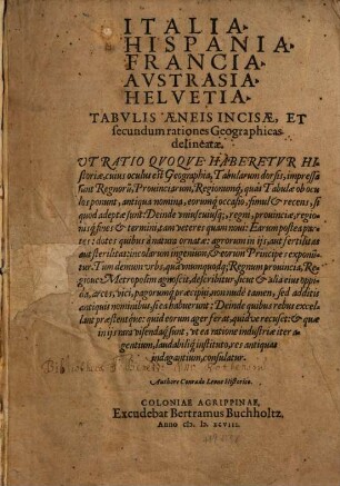
Kupferst.
Maßstab in graph. Form (Miglia). - Literatur in Meurer, Peter H.: The Strabo Illustratus Atlas ; 1545-1571
- Bibliographic citation
-
Cosmografia Universale ; [57]
- Keyword
-
Italien
- Event
-
Veröffentlichung
- (where)
-
Venetia//Venedig
- (when)
-
1569
- Contributor
- URN
-
urn:nbn:de:bvb:12-bsb00092062-9
- Last update
-
16.04.2025, 8:41 AM CEST
Data provider
This object is provided by:
Bayerische Staatsbibliothek. If you have any questions about the object, please contact the data provider.
Bayerische Staatsbibliothek. If you have any questions about the object, please contact the data provider.
Object type
- Altkarte
Associated
Time of origin
- 1569
Other Objects (12)

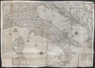
Italia Nvova

Italia Nuova
Dominium Venetum In Italia

Italia Novamente posta in Luce et da molti errori emendata
Il Disegno Della Geografia Moderna de Tvtta La Provincia De La Italia
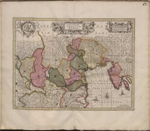
Italia, Hispania, Francia, Austrasia, Helvetia tabulis aeneis incisae, et secundum rationes Geographicas delineatae
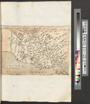
Disegno particolare de parte d'Italia, secondo la descritione della geografia di strabone la quale non s'a potesto desciuerla nel disegno dell'italia ch' e nel fine del sesto libro ma per magior lucidatione di quelle ch' a descritto strabone nel quinto libro suo s'a fatto questa tauola iiii
Disegno dell'italia secondo la descrittione della Geografia di strabone, nel fine del quarto libro, e sequita il quinto, et il sesto, Tavola iiii

Charte von Italien Nach der dermaligen Verfassung : auch mit dessen alten und neuen Grenzen, nach den bewährtesten Hülfsmitteln neu entworfen und gezeichnet = Carta D'Italia secondo la presento Costituzione

Carta Topografica del Regno D'Italia : Diviso ne Suoi Dipartimenti con il Parmigiano, Genovesato e Toscana fino a Firenze con parte dei Paesi confinanti Del Piemonte, Svizzeria, Grigioni, Tirolo, Carintia e Istria Dessunta da migliori Originali ; C. P. S. C. M. = Topographische Carte des Königreichs Italien
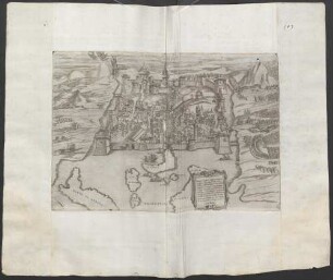
Quale et di quanta importanza é, bellezza sia la nobile cita di Napole in Italia ancora che sia nota à tutto il mondo, nondimeno à comodita et sodisfattione de nobili et virtuosi ingegni si è fatto questo suo vero ritratto, con li suoi moli, porte, chiesie, seggi, palazzi, piazzi, strade, fonti, et altri cose notabili come per l'infrascritti numeri annotati facilmente si può vedere
Begnini Lettori, Algieri, habuto rispetto alla proportione della Italia ...
Italia Nvova
Italia Nuova
Dominium Venetum In Italia
Italia Novamente posta in Luce et da molti errori emendata
Il Disegno Della Geografia Moderna de Tvtta La Provincia De La Italia
Italia, Hispania, Francia, Austrasia, Helvetia tabulis aeneis incisae, et secundum rationes Geographicas delineatae
Disegno particolare de parte d'Italia, secondo la descritione della geografia di strabone la quale non s'a potesto desciuerla nel disegno dell'italia ch' e nel fine del sesto libro ma per magior lucidatione di quelle ch' a descritto strabone nel quinto libro suo s'a fatto questa tauola iiii
Disegno dell'italia secondo la descrittione della Geografia di strabone, nel fine del quarto libro, e sequita il quinto, et il sesto, Tavola iiii
Charte von Italien Nach der dermaligen Verfassung : auch mit dessen alten und neuen Grenzen, nach den bewährtesten Hülfsmitteln neu entworfen und gezeichnet = Carta D'Italia secondo la presento Costituzione
Carta Topografica del Regno D'Italia : Diviso ne Suoi Dipartimenti con il Parmigiano, Genovesato e Toscana fino a Firenze con parte dei Paesi confinanti Del Piemonte, Svizzeria, Grigioni, Tirolo, Carintia e Istria Dessunta da migliori Originali ; C. P. S. C. M. = Topographische Carte des Königreichs Italien
Quale et di quanta importanza é, bellezza sia la nobile cita di Napole in Italia ancora che sia nota à tutto il mondo, nondimeno à comodita et sodisfattione de nobili et virtuosi ingegni si è fatto questo suo vero ritratto, con li suoi moli, porte, chiesie, seggi, palazzi, piazzi, strade, fonti, et altri cose notabili come per l'infrascritti numeri annotati facilmente si può vedere