Verzeichnung
Stadtplan Wilhelmshaven und Umgebung Maßstab: 1:10.000 Hersteller/Herausgeber.: Katasteramt Wilhelmshaven/Vermessungs- und Katasterverwaltung Oldenburg
- Reference number
-
Nds. Landesarchiv, Abt. Oldenburg, NLA OL, K-ZE, Best. 298 Z Nr. 1534
- Further information
-
Identifikation: Band:
Index-Gruppe: Institution: Katasteramt Wilhelmshaven
Index-Gruppe: Institution: Vermessungs- und Katasterverwaltung Oldenburg
- Context
-
Zentraler Kartenbestand Oldenburg >> 5 Bezirksregierung Weser-Ems >> 5.15 Stadt Wilhelmshaven >> 5.15.5 Feldmarken, Stadt- und Ortspläne, Flurstücke
- Holding
-
NLA OL, K-ZE Zentraler Kartenbestand Oldenburg
- Indexentry place
-
Wilhelmshaven, Karte
- Date of creation
-
- 1959
- Other object pages
- Last update
-
30.01.2023, 3:00 PM CET
Data provider
This object is provided by:
Niedersächsisches Landesarchiv. If you have any questions about the object, please contact the data provider.
Niedersächsisches Landesarchiv. If you have any questions about the object, please contact the data provider.
Object type
- Verzeichnung
Time of origin
- - 1959
Other Objects (12)

Stadtplan Wilhelmshaven und Umgebung Maßstab: 1:10.000 Bearbeiter: Katasteramt Wilhelmshaven Herausgeber: Vermessungs- und Katasterverwaltung Oldenburg
Vermessungs- & Katasterverwaltung
Arsenalbetrieb Wilhelmshaven (Marinearsenal Wilhelmshaven)
Metallwarenfabrik Wilhelmshaven AG, Wilhelmshaven
Motorwagen: Omnibus Wilhelmshaven, Anhänger: Wilhelmshaven
Motorwagen: Omnibus Wilhelmshaven, Anhänger: Wilhelmshaven
Motorwagen: Omnibus Wilhelmshaven, Anhänger: Wilhelmshaven
"Wilhelmshaven"
"Wilhelmshaven"
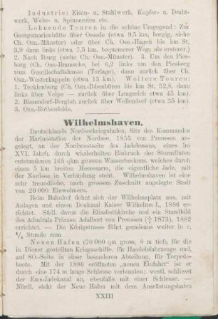
Wilhelmshaven.
Wilhelmshaven

Wilhelmshaven.
Stadtplan Wilhelmshaven und Umgebung Maßstab: 1:10.000 Bearbeiter: Katasteramt Wilhelmshaven Herausgeber: Vermessungs- und Katasterverwaltung Oldenburg
Vermessungs- & Katasterverwaltung
Arsenalbetrieb Wilhelmshaven (Marinearsenal Wilhelmshaven)
Metallwarenfabrik Wilhelmshaven AG, Wilhelmshaven
Motorwagen: Omnibus Wilhelmshaven, Anhänger: Wilhelmshaven
Motorwagen: Omnibus Wilhelmshaven, Anhänger: Wilhelmshaven
Motorwagen: Omnibus Wilhelmshaven, Anhänger: Wilhelmshaven
"Wilhelmshaven"
"Wilhelmshaven"
Wilhelmshaven.
Wilhelmshaven
Wilhelmshaven.
Stadtplan Wilhelmshaven und Umgebung Maßstab: 1:10.000 Bearbeiter: Katasteramt Wilhelmshaven Herausgeber: Vermessungs- und Katasterverwaltung Oldenburg
Vermessungs- & Katasterverwaltung
Arsenalbetrieb Wilhelmshaven (Marinearsenal Wilhelmshaven)
Metallwarenfabrik Wilhelmshaven AG, Wilhelmshaven
Motorwagen: Omnibus Wilhelmshaven, Anhänger: Wilhelmshaven
Motorwagen: Omnibus Wilhelmshaven, Anhänger: Wilhelmshaven
Motorwagen: Omnibus Wilhelmshaven, Anhänger: Wilhelmshaven
"Wilhelmshaven"
"Wilhelmshaven"
Wilhelmshaven.
Wilhelmshaven