Karten und Pläne
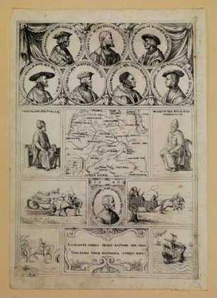
Situationsplan des nach zwei verschiedenen Systemen eingeteilten Mittelhofs (Inselkarte)
Enthält: Mittelhof, Kemmelhof im Grundriss
- Reference number
-
Landesarchiv Baden-Württemberg, Abt. Staatsarchiv Wertheim, R-K Nr. 424
- Dimensions
-
46 x 56 (Höhe x Breite)
- Notes
-
vgl. StAWt-R Lit. B 1164
- Further information
-
Ausführung: Federzeichnung; handkoloriert
Maßstab: [1:6000]
- Context
-
Karten und Pläne >> B. Baden >> B.22. Wertheim >> B.22.8. Höhefeld >> B.22.8.2. Mittelhof
- Holding
-
Landesarchiv Baden-Württemberg, Abt. Staatsarchiv Wertheim, R-K Karten und Pläne
- Creator
-
Autor/Fotograf: [Füssl]
- Date of creation
-
[1832]
- Other object pages
- View digital item at providers-website
- Rights
-
Es gelten die Nutzungsbedingungen des Landesarchivs Baden-Württemberg.
- Last update
-
26.03.2024, 9:03 AM CET
Data provider
This object is provided by:
Landesarchiv Baden-Württemberg. If you have any questions about the object, please contact the data provider.
Landesarchiv Baden-Württemberg. If you have any questions about the object, please contact the data provider.
Object type
- Karten und Pläne
Associated
- Autor/Fotograf: [Füssl]
Time of origin
- [1832]
Other Objects (12)

Karte der eingeteilten Heidenschen Gemeinheit, die Wellenheide (Amt Lage);. Inselkarte (2 Expl.)
Kartenausschnitte der eingeteilten Zählbezirke
Dorf Neuendorf; eingeteilte Äcker. Zwei Teilkarten auf einem Blatt.
Liste der mobmäßig eingeteilten Fachärzte
Situationsplan über die Gemarkung Helmstheim (Inselkarte)
In Standortmusiken nicht eingeteilte Musiker Namenslisten
Verzeichnis der nicht ständig eingeteilten Eisenbahnpraktikanten
Eine in 10 Felder eingeteilte Radierung
Verzeichnis der nicht ständig eingeteilten Eisenbahnanwärter
Verzeichnis der nicht ständig eingeteilten Eisenbahnpraktikanten
Verzeichnis der nicht ständig eingeteilten Eisenbahnanwärter
Gemarkungskarte mit eingeteilten Schlägen in Kieshof
Karte der eingeteilten Heidenschen Gemeinheit, die Wellenheide (Amt Lage);. Inselkarte (2 Expl.)
Kartenausschnitte der eingeteilten Zählbezirke
Dorf Neuendorf; eingeteilte Äcker. Zwei Teilkarten auf einem Blatt.
Liste der mobmäßig eingeteilten Fachärzte
Situationsplan über die Gemarkung Helmstheim (Inselkarte)
In Standortmusiken nicht eingeteilte Musiker Namenslisten
Verzeichnis der nicht ständig eingeteilten Eisenbahnpraktikanten
Eine in 10 Felder eingeteilte Radierung
Verzeichnis der nicht ständig eingeteilten Eisenbahnanwärter
Verzeichnis der nicht ständig eingeteilten Eisenbahnpraktikanten
Verzeichnis der nicht ständig eingeteilten Eisenbahnanwärter