Karten und Pläne
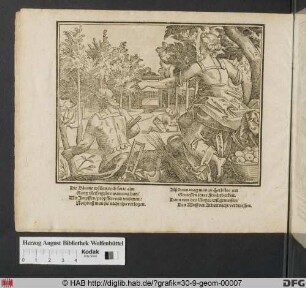
Uhlandplatz, Situationsplan mit doppelter, kreisförmiger Anordnung der Baumpflanzung hinter dem Monument (Entwurf)
- Reference number
-
D 30/K 2226/15
- Former reference number
-
prefix: D 30/K
- Dimensions
-
35 x 30 cm
- Formal description
-
zwischen Neckar und Bahnhof
- Material
-
Pergamin
- Notes
-
Die geplanten Gebäude am Uhlandplatz sind mit römischen Zahlen beziffert. Leins entwarf dazu Einzelpläne: vgl. K2226/18-K2226/23. Siehe Repro
- Further information
-
Ausführung: Tusche, koloriert
Maßstab: 1:1250
Druck / Verlag: Leins, C. F., Architekt, Stuttgart
- Context
-
D 30 Karten- und Plansammlung >> Anlagen und Straßen >> Denkmäler
- Holding
-
D 30 Karten- und Plansammlung
- Indexbegriff subject
-
#N/A
- Indexentry place
-
Tübingen, Uhlandplatz
- Date of creation
-
ca. 1869
- Other object pages
- Last update
-
29.04.2025, 8:35 AM CEST
Data provider
This object is provided by:
Stadtarchiv Tübingen. If you have any questions about the object, please contact the data provider.
Stadtarchiv Tübingen. If you have any questions about the object, please contact the data provider.
Object type
- Karte und Plan
Time of origin
- ca. 1869
Other Objects (12)

Uhlandplatz, Situationsplan mit rechteckiger Anordnung der Baumpflanzung hinter dem Monument (Entwurf)
Situationsplan von der Baumpflanzung im Aftholderloh
Uhlandplatz, Situationsplan mit kreisförmiger Anordnung der Baumbepflanzung und Stellung der rückwärts vom Monument befindlichen Gebäude im Achteck (Entwurf)
Baumpflanzung
Baumpflanzung
Baumpflanzung
Baumpflanzung
Baumpflanzung
Baumpflanzung.
Baumpflanzung
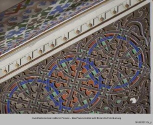
Kreisförmiges Flechtwerkornament
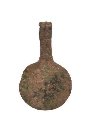
Kreisförmiger Anhänger
Uhlandplatz, Situationsplan mit rechteckiger Anordnung der Baumpflanzung hinter dem Monument (Entwurf)
Situationsplan von der Baumpflanzung im Aftholderloh
Uhlandplatz, Situationsplan mit kreisförmiger Anordnung der Baumbepflanzung und Stellung der rückwärts vom Monument befindlichen Gebäude im Achteck (Entwurf)
Baumpflanzung
Baumpflanzung
Baumpflanzung
Baumpflanzung
Baumpflanzung
Baumpflanzung.
Baumpflanzung
Kreisförmiges Flechtwerkornament