Karten / Pläne
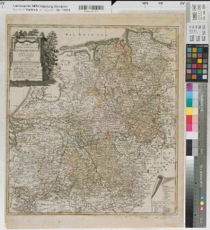
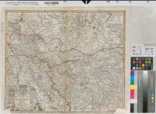
Rheinland Territorialkarte 1800 15 dt. Meilen = 20,6 cm 58 x 67 farb. Stich: J. Stockdale, London
- Reference number
-
W 051, 15826
- Further information
-
Ort: Rheinland
- Context
-
Karten A (Allgemein) >> 1. Topographische Karte, Übersichtskarten >> 1.3. Territorialkarten
- Holding
-
W 051 Karten A (Allgemein)
- Indexentry place
-
Rheinland
Rheinland, Territorialkarte, 1800
- Provenance
-
Sammlungsregistraturbildner
- Date of creation
-
1800
- Other object pages
- Delivered via
- Last update
-
30.04.2025, 3:21 PM CEST
Data provider
This object is provided by:
Landesarchiv Nordrhein-Westfalen. Abteilung Westfalen. If you have any questions about the object, please contact the data provider.
Landesarchiv Nordrhein-Westfalen. Abteilung Westfalen. If you have any questions about the object, please contact the data provider.
Object type
- Karten / Pläne
Associated
- Sammlungsregistraturbildner
Time of origin
- 1800
Other Objects (12)
Westfälischer Kreis Territorialkarte 1789 8 geogr. Meilen = 7,1 cm 52 x 46,5 farb. Stich: Nürnberg Homann F. L. Güssefeld

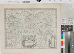
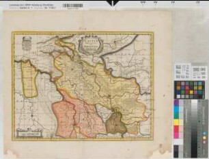
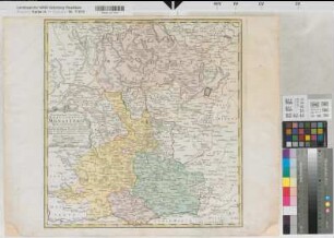
Jülich (Herzogtum) Territorialkarte Juliacensis ducatus 17.Jh. 2 dt. Meilen = 6,05 cm 40 x 55,5 farb. Stich: (Simon Schropp & Co, Berlin)
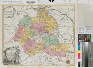
Mark (Grafschaft) Ravensberg (Grafschaft) Territorialkarte 17.Jh. 2 dt. Meilen = 5,6 cm 36 x 47 Stich
Paderborn (Bistum) Territorialkarte 18.Jh. 3 dt. Meilen = 9,5 cm 47,5 x 53 farb. Stich: Matthaeus Seutter, Augsburg Tob. Con. Lotter sc. Bem.: Stadtansicht
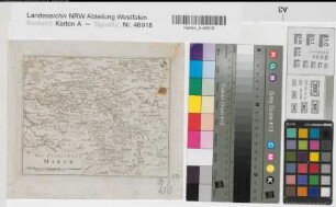
Mark, Grafschaft Territorialkarte (1779) 5 deutsche Meilen = 7,1 cm 15,5 x 10 Stich B 330
Kleve (Herzogtum) Ravenstein (Herrschaft) Territorialkarte 17.Jh. 2 dt. Meilen = 6,25 cm 35,5 x 47,5 farb. Stich: P. Schenk und G. Valk C.P., Amsterdam
Lippe (Grafschaft) Territorialkarte mit den Ämtern 1762 1 dt. Meile = 8,4 cm 48 x 57 farb. Stich: Tobias Conrad Lotter, Augsburg Georg Frid. Lotter sculps.
Kleve (Herzogtum) Territorialkarte Nieuwe Kaart van het Hertogdom Kleef um 1700 2 dt. Meilen = 7,4 cm 46 x 56 farb. Stich: R. & I. Lottens, Amsterdam
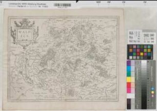
Waldeck (Grafschaft) Territorialkarte Waldeck comitatus 17.Jh. 1 waldeck. Meile = 5 cm 33,5 x 44 Stich Gerhard Mercator
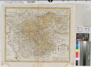
Mark (Grafschaft) Territorialkarte mit Kreisen, Ämtern und Gerichtsbezirken Charte von der Grafschaft Mark 1796 4 dt. Meilen = 12,9 cm 43 x 52 farb. Stich: Homanns Erben, Nürnberg
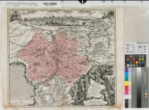
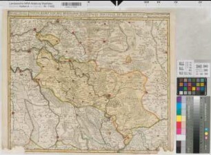
Münster (Fürstbistum) Territorialkarte Territorium seculare episcopatus Monasterii Munster Germanis dicti 1757 5 dt. Meilen = 8,85 cm 47,5 x 45 farb. Stich: Homanns Erben (Nürnberg) Bem.: Wappenvignette
Kleve (Herzogtum) Mark (Grafschaft) Territorialkarte Nova et accurata Cliviae et comitatus Marchiae 18.Jh. 3 dt. Meilen = 6,7 cm 47,5 x 56 farb. Stich: Matthaeus Seutter, Augsburg
Westfälischer Kreis Territorialkarte 1789 8 geogr. Meilen = 7,1 cm 52 x 46,5 farb. Stich: Nürnberg Homann F. L. Güssefeld
Jülich (Herzogtum) Territorialkarte Juliacensis ducatus 17.Jh. 2 dt. Meilen = 6,05 cm 40 x 55,5 farb. Stich: (Simon Schropp & Co, Berlin)
Mark (Grafschaft) Ravensberg (Grafschaft) Territorialkarte 17.Jh. 2 dt. Meilen = 5,6 cm 36 x 47 Stich
Paderborn (Bistum) Territorialkarte 18.Jh. 3 dt. Meilen = 9,5 cm 47,5 x 53 farb. Stich: Matthaeus Seutter, Augsburg Tob. Con. Lotter sc. Bem.: Stadtansicht
Mark, Grafschaft Territorialkarte (1779) 5 deutsche Meilen = 7,1 cm 15,5 x 10 Stich B 330
Kleve (Herzogtum) Ravenstein (Herrschaft) Territorialkarte 17.Jh. 2 dt. Meilen = 6,25 cm 35,5 x 47,5 farb. Stich: P. Schenk und G. Valk C.P., Amsterdam
Lippe (Grafschaft) Territorialkarte mit den Ämtern 1762 1 dt. Meile = 8,4 cm 48 x 57 farb. Stich: Tobias Conrad Lotter, Augsburg Georg Frid. Lotter sculps.
Kleve (Herzogtum) Territorialkarte Nieuwe Kaart van het Hertogdom Kleef um 1700 2 dt. Meilen = 7,4 cm 46 x 56 farb. Stich: R. & I. Lottens, Amsterdam
Waldeck (Grafschaft) Territorialkarte Waldeck comitatus 17.Jh. 1 waldeck. Meile = 5 cm 33,5 x 44 Stich Gerhard Mercator
Mark (Grafschaft) Territorialkarte mit Kreisen, Ämtern und Gerichtsbezirken Charte von der Grafschaft Mark 1796 4 dt. Meilen = 12,9 cm 43 x 52 farb. Stich: Homanns Erben, Nürnberg
Münster (Fürstbistum) Territorialkarte Territorium seculare episcopatus Monasterii Munster Germanis dicti 1757 5 dt. Meilen = 8,85 cm 47,5 x 45 farb. Stich: Homanns Erben (Nürnberg) Bem.: Wappenvignette