- Location
-
München, Bayerische Staatsbibliothek -- Mapp. XI,535 zv
- Dimensions
-
94 x 94 cm
- Extent
-
1 Kt.
- Notes
-
Lithographie
Maßstab in graph. Form (Bayer. Fuß). - Zusammengesetzt aus d. Flurkarten N.W. LXXX,51 a-d
- Keyword
-
Katasterkarte
Würzburg
- Event
-
Veröffentlichung
- (where)
-
München
- (who)
-
[Topographisches Bureau]
- (when)
-
[ca. 1870]
- Contributor
- URN
-
urn:nbn:de:bvb:12-bsb00105397-1
- Last update
-
16.04.2025, 8:46 AM CEST
Data provider
This object is provided by:
Bayerische Staatsbibliothek. If you have any questions about the object, please contact the data provider.
Bayerische Staatsbibliothek. If you have any questions about the object, please contact the data provider.
Object type
- Altkarte
- Stadtplan
Associated
- Päringer, Josef
- Wimberger, Karl
- Weishaupt
- [Topographisches Bureau]
Time of origin
- [ca. 1870]
Other Objects (12)
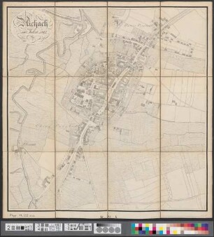
Aichach im Jahre 1865
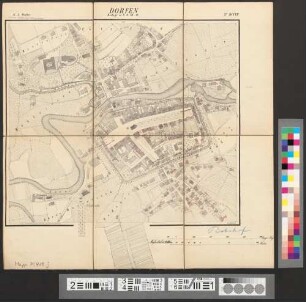
Dorfen : Beilage zu N.O. VII.19 ; No. DCCVII
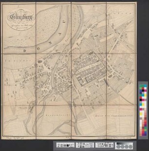
Günzburg : gemessen im Jahre 1823. Gravirt 1826

Österreichs Schlachtfelder, Bd. 2.. Kesselsdorf 1745, Lobositz 1756, Kolin 1757, Rossbach 1757, Hochkirch 1758, Maxen 1759, Torgau 1760, Freiberg 1762
Schlösser, Burgen und Ruinen der Steiermark, Bd. 2.
Technik an meinem Lebensweg : als Frau und Ingenieur in der Frühzeit der Luftfahrttechnik
Die Globetrotterin, Bd. 3.. Syrien, Libanon, Jordanien, Marokko, Indien, Costa Rica, Panama, San-Blas-Inseln
Österreichs Schlachtfelder, Bd. 4.. Trautenau 1866, Nachod 1866, Skalitz 1866, Königgrätz 1866

Zur Charakteristik der Dschagganeger
Die Flugzeuge der österreichischen Luftstreitkräfte vor 1938, [Teil 1].
Sie können die Sonne nicht verhaften
Österreichs Schlachtfelder, Bd. 1.. Breitenfeld 1631, Lützen 1632, Breitenfeld 1642
Aichach im Jahre 1865
Dorfen : Beilage zu N.O. VII.19 ; No. DCCVII
Günzburg : gemessen im Jahre 1823. Gravirt 1826
Österreichs Schlachtfelder, Bd. 2.. Kesselsdorf 1745, Lobositz 1756, Kolin 1757, Rossbach 1757, Hochkirch 1758, Maxen 1759, Torgau 1760, Freiberg 1762
Schlösser, Burgen und Ruinen der Steiermark, Bd. 2.
Technik an meinem Lebensweg : als Frau und Ingenieur in der Frühzeit der Luftfahrttechnik
Die Globetrotterin, Bd. 3.. Syrien, Libanon, Jordanien, Marokko, Indien, Costa Rica, Panama, San-Blas-Inseln
Österreichs Schlachtfelder, Bd. 4.. Trautenau 1866, Nachod 1866, Skalitz 1866, Königgrätz 1866
Zur Charakteristik der Dschagganeger
Die Flugzeuge der österreichischen Luftstreitkräfte vor 1938, [Teil 1].
Sie können die Sonne nicht verhaften