- Location
-
München, Bayerische Staatsbibliothek -- 2 Mapp. 284 y
- Dimensions
-
59 x 30 cm, Bildgr. 64 x 48 cm
- Extent
-
1 Kt.
- Language
-
Deutsch
- Notes
-
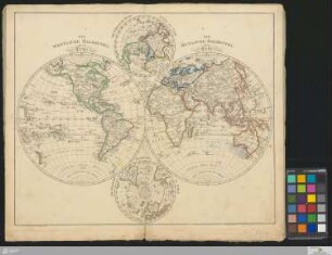
Kupferstich
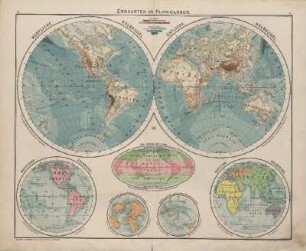
Erdkt. in 2 Hemisphären. - Mit Bergstrichen
- Bibliographic citation
-
Gaspari, Adam C.: Allgemeiner Hand-Atlas der Ganzen Erde ; I
- Keyword
-
Planiglob
Weltkarte
- Event
-
Veröffentlichung
- (where)
-
Weimar
- (who)
-
Verlag des Geograph. Instituts
- (when)
-
1821
- Contributor
- URN
-
urn:nbn:de:bvb:12-bsb00061723-1
- Last update
-
16.04.2025, 8:42 AM CEST
Data provider
This object is provided by:
Bayerische Staatsbibliothek. If you have any questions about the object, please contact the data provider.
Bayerische Staatsbibliothek. If you have any questions about the object, please contact the data provider.
Object type
- Altkarte
Associated
- Weiland, Karl Ferdinand
- Verlag des Geograph. Instituts
Time of origin
- 1821
Other Objects (12)

Oestliche und Westliche Halbkugel der Erde
Westliche Halbkugel. Östliche Halbkugel. Die Zonen der Erde
Westliche Halbkugel Östliche Halbkugel
Westliche Halbkugel Östliche Halbkugel
Westliche Halbkugel, Oestliche Halbkugel
![[OESTLICHE HALBKUGEL und WESTLICHE HALBKUGEL]](https://iiif.deutsche-digitale-bibliothek.de/image/2/a4cc0e9c-d3b0-476b-ae62-73c4d4a427eb/full/!306,450/0/default.jpg)
[OESTLICHE HALBKUGEL und WESTLICHE HALBKUGEL]
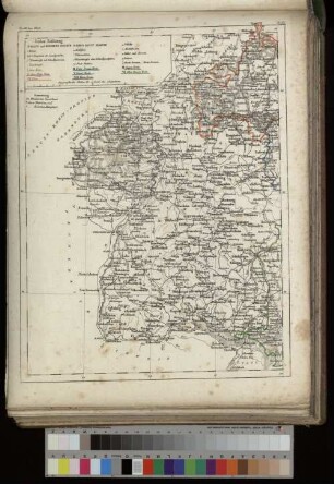
Das Koenigreich Baiern : in 2 Blättern. Oestliches Blatt. Westliches Blatt
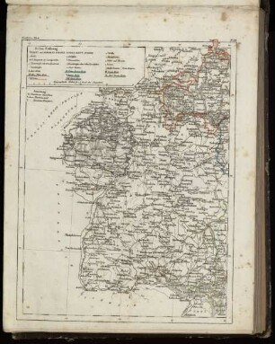
Das Koenigreich Baiern : in 2 Blättern. Oestliches Blatt. Westliches Blatt
Die westliche Halbkugel der Erde, die östliche Halbkugel der Erde : die nördliche Halbkugel der Erde, die südliche Halbkugel der Erde
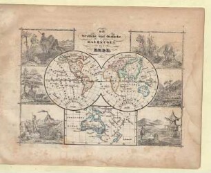
Die Westliche und Oestliche Halbkugel der Erde
![[Westliche Hemisphäre]](https://iiif.deutsche-digitale-bibliothek.de/image/2/cd398694-6316-4906-b115-c9a4cb2e3f90/full/!306,450/0/default.jpg)
[Westliche Hemisphäre]
![[Westliche Hemishphäre]](https://iiif.deutsche-digitale-bibliothek.de/image/2/76bc38ff-71a9-4c73-9e21-fc2b91a0c27f/full/!306,450/0/default.jpg)
[Westliche Hemishphäre]
Oestliche und Westliche Halbkugel der Erde
Westliche Halbkugel. Östliche Halbkugel. Die Zonen der Erde
Westliche Halbkugel Östliche Halbkugel
Westliche Halbkugel Östliche Halbkugel
Westliche Halbkugel, Oestliche Halbkugel
[OESTLICHE HALBKUGEL und WESTLICHE HALBKUGEL]
Das Koenigreich Baiern : in 2 Blättern. Oestliches Blatt. Westliches Blatt
Das Koenigreich Baiern : in 2 Blättern. Oestliches Blatt. Westliches Blatt
Die westliche Halbkugel der Erde, die östliche Halbkugel der Erde : die nördliche Halbkugel der Erde, die südliche Halbkugel der Erde
Die Westliche und Oestliche Halbkugel der Erde
[Westliche Hemisphäre]