Karte
Ukrania quae et Terra Cosaccorum cum vicinis Walachiae, Moldaviae, Minorisque Tartariae provinciis : Cum Privilegio Sac. Caes. Maiestatis
- Standort
-
Leibniz-Institut für Länderkunde e.V., Leipzig
- Weitere Nummer(n)
-
HK 0002 (Signatur)
- Material/Technik
-
flächenkolor.
- Inschrift/Beschriftung
-
Kupferst. - Relief plastisch als einzelne Hügel. - Maßstab in graph. Form (Milliaria Germanica, Milliaria Polonica). - Titelkartusche oben links. - Maßstab u. Erl. im Kt.-Bild
- Bezug (was)
-
Altkarte
Osteuropa
Moldau
Ukraine
Valašsko (Walachei)
Tatarstan (Respublika)
Krim (Avtonomna Respublika)
- Ereignis
-
Veröffentlichung
- (wer)
-
Homann (Verlag)
- (wo)
-
Noribergae
- (wann)
-
[ca. 1720]
- Rechteinformation
-
Leibniz-Institut für Länderkunde e.V.
- Letzte Aktualisierung
-
15.05.2025, 12:43 MESZ
Datenpartner
Dieses Objekt wird bereitgestellt von:
Leibniz-Institut für Länderkunde e. V.. Bei Fragen zum Objekt wenden Sie sich bitte an den Datenpartner.
Leibniz-Institut für Länderkunde e. V.. Bei Fragen zum Objekt wenden Sie sich bitte an den Datenpartner.
Objekttyp
- Karte
Beteiligte
- Homann (Verlag)
Entstanden
- [ca. 1720]
Ähnliche Objekte (12)
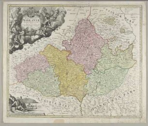
Tabula Generalis Marchionatus Moraviae In Sex Circulos Divisae : Cum Privilegio Sac. Caes. Maiestatis
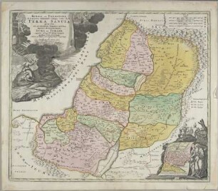
Iudaea Seu Palaestina ob sacratißima Redentoris vestigia hodie dicta Terra Sancta prout olim In Duodecim Tribus Divisa, separatis ab invicem Regnis Iuda Et Israel expreßis insuper VI. ultimi temporis ejusdem Terrae Provinciis : Cum Privilegio Sac. Caes. Maiestatis
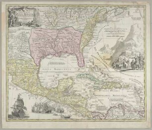
Regni Mexicani Seu Novae Hispaniae, Ludovicianae, N. Angliae, Carolinae, Virginiae et Pensylvaniae nec non Insularum Archipelagi Mexicani In America Septentrionali accurata Tabula : Cum Privilegio Sac. Caes. Maiestatis
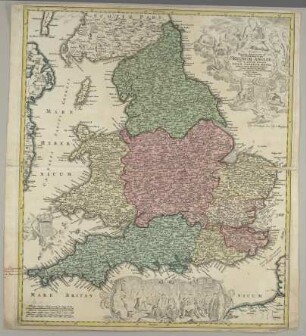
Magnae Britanniae Pars Meridionalis in qua Regnum Angliae Tam in Septem Antiqua Anglo-Saxonum Regna quam in omnes Hodiernas Regiones accurate divisum hic ostenditur : Cum Privilegio Sac. Caes. Maiestatis
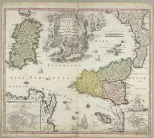
Regnorum Siciliae Et Sardiniae nec non Melitae seu Maltae Insula cum adjectis Italiae et Africae Litoribus Nova Tabula : Cum Privilegio Sac. Caes. Majestatis

Imperium Turcicum in Europa, Asia et Africa : Regiones Proprias, Tributarias, Clientilaresque sicut et omnes eusdem Beglirbegatus seu Praefecturas Generales exhibens ; Cum Privil. S. C. M.

Bistum Münster mit den Nachbargebieten "Territorium seculare episcopatus Monasterri . . . ubi una cum episcopatu Osnabr. simul integri comitatus Bentheim, Steinfurt, Tecklenburg, Lingen, Diepholz, Gemen conspiciuntur" Ausf.-Art: Farbiger Stich Herst.: Homann Format: 49 x 47 cm Maßstab: 1 : 350 - 400 000
Beiträge zur Schulpraxis in Volks- oder Elementarschulen, H. 3.. Ein Beitrag zur Aufgabe und Arbeit der deutschen Volksschule in Betreff der sprachlichen Bildung ihrer Schüler
Beiträge zur Schulpraxis in Volks- oder Elementarschulen, H. 2
Deutschland, Poststraßen "Neue und vollständige Postkarte durch ganz Deutschland und durch die angränzenden Theile der banchbarten Länder." Mit Entfernungsangaben (vor allem in Norddeutschland). Legende 2. Auflage (1796) der Karte von 1786 Ausf.-Art: Druck, Grenzen farbig Herst.: Homann Format: 75 x 95 cm Maßstab: 1 : 1 500 000
Deutschland, Poststraßen "Neue und vollständige Postkarte durch ganz Deutschland und durch die angränzenden Theile der banchbarten Länder." Mit Entfernungsangaben (vor allem in Norddeutschland). Legende 2. Auflage (1796) der Karte von 1786 Ausf.-Art: Druck, Grenzen farbig Herst.: Homann Format: 75 x 95 cm Maßstab: 1 : 1 500 000
Der Rhein und sein weiteres Umland (bis zur Länge von Saarlouis und Hanau) von Basel bis Bonn, 2. Hälfte des 18. Jahrhunderts "Cursus Rheni a Basilea usque ad Bonnam." In drei (hier zusammengeklebten) Sectionen. Politische Darstellung Ausf.-Art: Farbiger Druck Herst.: Homann Format: 137 x 61 cm Maßstab: 1 : 300 000
Tabula Generalis Marchionatus Moraviae In Sex Circulos Divisae : Cum Privilegio Sac. Caes. Maiestatis
Iudaea Seu Palaestina ob sacratißima Redentoris vestigia hodie dicta Terra Sancta prout olim In Duodecim Tribus Divisa, separatis ab invicem Regnis Iuda Et Israel expreßis insuper VI. ultimi temporis ejusdem Terrae Provinciis : Cum Privilegio Sac. Caes. Maiestatis
Regni Mexicani Seu Novae Hispaniae, Ludovicianae, N. Angliae, Carolinae, Virginiae et Pensylvaniae nec non Insularum Archipelagi Mexicani In America Septentrionali accurata Tabula : Cum Privilegio Sac. Caes. Maiestatis
Magnae Britanniae Pars Meridionalis in qua Regnum Angliae Tam in Septem Antiqua Anglo-Saxonum Regna quam in omnes Hodiernas Regiones accurate divisum hic ostenditur : Cum Privilegio Sac. Caes. Maiestatis
Regnorum Siciliae Et Sardiniae nec non Melitae seu Maltae Insula cum adjectis Italiae et Africae Litoribus Nova Tabula : Cum Privilegio Sac. Caes. Majestatis
Imperium Turcicum in Europa, Asia et Africa : Regiones Proprias, Tributarias, Clientilaresque sicut et omnes eusdem Beglirbegatus seu Praefecturas Generales exhibens ; Cum Privil. S. C. M.
Bistum Münster mit den Nachbargebieten "Territorium seculare episcopatus Monasterri . . . ubi una cum episcopatu Osnabr. simul integri comitatus Bentheim, Steinfurt, Tecklenburg, Lingen, Diepholz, Gemen conspiciuntur" Ausf.-Art: Farbiger Stich Herst.: Homann Format: 49 x 47 cm Maßstab: 1 : 350 - 400 000
Beiträge zur Schulpraxis in Volks- oder Elementarschulen, H. 3.. Ein Beitrag zur Aufgabe und Arbeit der deutschen Volksschule in Betreff der sprachlichen Bildung ihrer Schüler
Beiträge zur Schulpraxis in Volks- oder Elementarschulen, H. 2
Deutschland, Poststraßen "Neue und vollständige Postkarte durch ganz Deutschland und durch die angränzenden Theile der banchbarten Länder." Mit Entfernungsangaben (vor allem in Norddeutschland). Legende 2. Auflage (1796) der Karte von 1786 Ausf.-Art: Druck, Grenzen farbig Herst.: Homann Format: 75 x 95 cm Maßstab: 1 : 1 500 000
Deutschland, Poststraßen "Neue und vollständige Postkarte durch ganz Deutschland und durch die angränzenden Theile der banchbarten Länder." Mit Entfernungsangaben (vor allem in Norddeutschland). Legende 2. Auflage (1796) der Karte von 1786 Ausf.-Art: Druck, Grenzen farbig Herst.: Homann Format: 75 x 95 cm Maßstab: 1 : 1 500 000