Altkarte
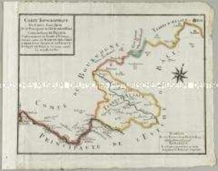
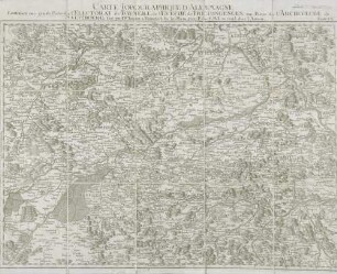
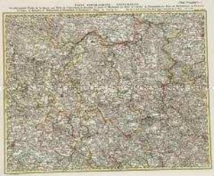
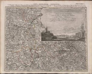
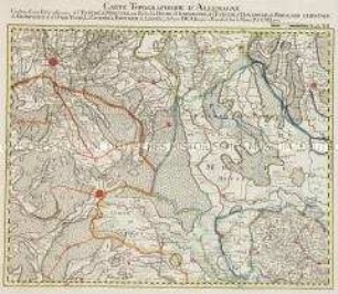
Partie Septentrionale Du Duché De Brabant : où se trouvent les Mairies de Bosleduc de Turnhout, de Santhoven, d'Hérentals, les Marquisats de Berg-op-Zoom, et du St. Empire, la Baronie de Bréda, partie de la Seigneurie de Malines, et de l'Evêché de Lyége &c. ; Avec Privilége
- Alternative title
-
Duché De Brabant
- Location
-
München, Bayerische Staatsbibliothek -- 2 Mapp. 153
- Dimensions
-
57 x 47 cm
- Extent
-
1 Kt.
- Language
-
Französisch
- Notes
-
Kupferstich
Maßstab in graph. Form (Mille Pas Geometriques, Lieues de Brabant, Lieues communes d'Allemagne)
- Bibliographic citation
-
Robert de Vaugondy, Gilles: Atlas universel ; 50
- Keyword
-
Herzogtum Brabant
- Event
-
Veröffentlichung
- (where)
-
[Paris]
- (when)
-
1752 [erschienen: 1757 - 58]
- Contributor
- URN
-
urn:nbn:de:bvb:12-bsb00105935-0
- Last update
-
16.04.2025, 8:35 AM CEST
Data provider
This object is provided by:
Bayerische Staatsbibliothek. If you have any questions about the object, please contact the data provider.
Bayerische Staatsbibliothek. If you have any questions about the object, please contact the data provider.
Object type
- Altkarte
Associated
Time of origin
- 1752 [erschienen: 1757 - 58]
Other Objects (12)

BASSE PARTIE DE L'EVECHÉ DE MÜNSTER
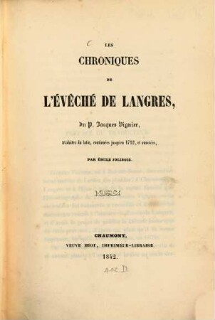
Les Chroniques de l'évêché de Langres
Carte Topographique des Limites d'une Partie de la Principauté de l'Evêche de Bâle contre les Terres de France
Grand Atlas . Bl. 21 (Westfalen, Münster,Osnabrück, Dortmund...) : Contenant une Partie du Cercle De Westphalie, savoir des Duchés De Gueldres et de Cleve, de L'Eveché de Munstre, L'Eveché d'Osnabrugg, les Comtés de Zutphen, de Steinfort, Recklinghausen, la Marck, Tecklenbourg, la Baronie de Wisch, la Ville de Dortmund
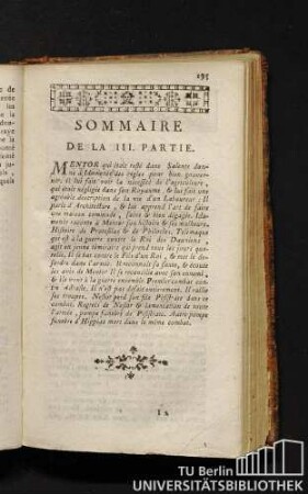
Sommaire de la III. partie. Les avantures de telemaque, troisieme partie.
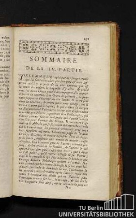
Sommaire de la IV. partie. Les avantures de telemaque, quatrieme partie.
60: Carte Topographique D'Allemagne Contenant une grande Partie de l'Electorat de Baviere, de l'Eveché de Freisingengen, une Partie de l'Archeveché de Saltzbourg
Grand Atlas . Bl. 31 (Hessen, Hannover, Westfalen...): Contenante La plus grande Partie de la Hesse, une Partie de l'Electorale de Hanovre, la Duché de Wesphalie, une Partie de l'Evêché de Paderborn, une Partie du Principeaute de Nassau, les Comtes de Waldeck, de Berlebourg, de Witgenstein, de Hatzfeld, l'abbaye de Corvey et c
Carte Topographique Contenante La plus grande Partie de la Hesse, une Partie de l'Electorale de Hanovre, la Duché de Wesphalie, une Partie de l'Evêché de Paderborn, une Partie du Principeaute de Nassau, les Comtes de Waldeck, de Berlebourg, de Witgenstein, de Hatzfeld, l'abbaye de Corvey etc ; a. P. d. S. M. I.
Études sur les origines de l'évêché de Bayeux, I
Sommaire de la suite de la IV. partie. Les avantures de telemaque, suite de la IV. partie.
Grand Atlas . Bl. 12 (Münster, Oldenburg, Osnabrück, Ostfriesland): Contenant une Partie inferieure de l'Evêché de Munster, une Partie du Duche D'Oldenbourg, de l'Evêché d'Osnabruck, de Friesland Orientale de Gröningen et d'Over-Yssel, les Comtés de Benthem de Lingen et et
BASSE PARTIE DE L'EVECHÉ DE MÜNSTER
Les Chroniques de l'évêché de Langres
Carte Topographique des Limites d'une Partie de la Principauté de l'Evêche de Bâle contre les Terres de France
Grand Atlas . Bl. 21 (Westfalen, Münster,Osnabrück, Dortmund...) : Contenant une Partie du Cercle De Westphalie, savoir des Duchés De Gueldres et de Cleve, de L'Eveché de Munstre, L'Eveché d'Osnabrugg, les Comtés de Zutphen, de Steinfort, Recklinghausen, la Marck, Tecklenbourg, la Baronie de Wisch, la Ville de Dortmund
Sommaire de la III. partie. Les avantures de telemaque, troisieme partie.
Sommaire de la IV. partie. Les avantures de telemaque, quatrieme partie.
60: Carte Topographique D'Allemagne Contenant une grande Partie de l'Electorat de Baviere, de l'Eveché de Freisingengen, une Partie de l'Archeveché de Saltzbourg
Grand Atlas . Bl. 31 (Hessen, Hannover, Westfalen...): Contenante La plus grande Partie de la Hesse, une Partie de l'Electorale de Hanovre, la Duché de Wesphalie, une Partie de l'Evêché de Paderborn, une Partie du Principeaute de Nassau, les Comtes de Waldeck, de Berlebourg, de Witgenstein, de Hatzfeld, l'abbaye de Corvey et c
Carte Topographique Contenante La plus grande Partie de la Hesse, une Partie de l'Electorale de Hanovre, la Duché de Wesphalie, une Partie de l'Evêché de Paderborn, une Partie du Principeaute de Nassau, les Comtes de Waldeck, de Berlebourg, de Witgenstein, de Hatzfeld, l'abbaye de Corvey etc ; a. P. d. S. M. I.
Études sur les origines de l'évêché de Bayeux, I
Sommaire de la suite de la IV. partie. Les avantures de telemaque, suite de la IV. partie.