THE CONTRIBUTION OF GIS IN FLOOD MAPPING: TWO APPROACHES USING OPEN SOURCE GRASS GIS SOFTWARE
- Standort
-
Deutsche Nationalbibliothek Frankfurt am Main
- Umfang
-
Online-Ressource
- Sprache
-
Englisch
- Erschienen in
-
THE CONTRIBUTION OF GIS IN FLOOD MAPPING: TWO APPROACHES USING OPEN SOURCE GRASS GIS SOFTWARE ; volume:XL-5/W3 ; year:2014 ; pages:175-178
The International Archives of the Photogrammetry, Remote Sensing and Spatial Information Sciences ; XL-5/W3 (2014), 175-178
- Urheber
-
Marzocchi, R.
Federici, B.
Cannata, M.
Cosso, T.
Syriou, A.
- DOI
-
10.5194/isprsarchives-XL-5-W3-175-2013
- URN
-
urn:nbn:de:101:1-2017112110204
- Rechteinformation
-
Open Access; Der Zugriff auf das Objekt ist unbeschränkt möglich.
- Letzte Aktualisierung
-
15.08.2025, 07:23 MESZ
Datenpartner
Dieses Objekt wird bereitgestellt von:
Deutsche Nationalbibliothek. Bei Fragen zum Objekt wenden Sie sich bitte an den Datenpartner.
Deutsche Nationalbibliothek. Bei Fragen zum Objekt wenden Sie sich bitte an den Datenpartner.
Beteiligte
- Marzocchi, R.
- Federici, B.
- Cannata, M.
- Cosso, T.
- Syriou, A.
Ähnliche Objekte (12)

GIS GRASS-embedded decision support framework for flood forecasting
GIS GRASS-embedded decision support framework for flood forecasting
Zeitreihenanalyse mit GRASS GIS
GRASS GIS in the sky: GRASS GIS as high-performance remote sensing toolbox
Scientific 3D Printing with GRASS GIS
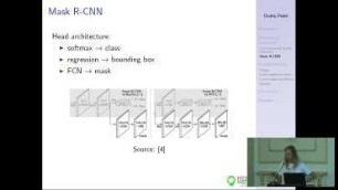
CNN-based tools in GRASS GIS
GRASS GIS in der Cloud: Actinia-Geoprozessierung
GRASS GIS in the cloud: actinia geoprocessing
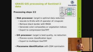
Processing Copernicus Sentinel data with GRASS GIS

Ausblick auf das kommende GRASS GIS 8
Wie schreibe ich ein GRASS GIS Addon?
OpenSource GIS surveying - water application
GIS GRASS-embedded decision support framework for flood forecasting
GIS GRASS-embedded decision support framework for flood forecasting
Zeitreihenanalyse mit GRASS GIS
GRASS GIS in the sky: GRASS GIS as high-performance remote sensing toolbox
Scientific 3D Printing with GRASS GIS
CNN-based tools in GRASS GIS
GRASS GIS in der Cloud: Actinia-Geoprozessierung
GRASS GIS in the cloud: actinia geoprocessing
Processing Copernicus Sentinel data with GRASS GIS
Ausblick auf das kommende GRASS GIS 8
Wie schreibe ich ein GRASS GIS Addon?