Karte / Plan
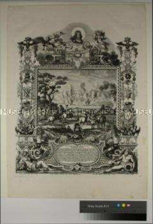
"Siège de Kaiserswerth en 1702" (Belagerung von Kaiserswerth), Kopie
- Reference number
-
5-1-0 Plankammer, 5-1-0-2835.0000
- Dimensions
-
1000 x 710
- Formal description
-
Die Karte zeigt die Stellungen der feindlichen Truppen um die Festung Kaiserswerth; Farbkopie eines Stichs.
- Material
-
Papier
- Further information
-
Ausführung: Kopie; farbig
Maßstab: 1:10.000
- Context
-
Plankammer >> Bürgermeisterei Kaiserswerth (bis zur Eingemeindung 1929) >> Festung und Stadttore, auch die Pfalz
- Holding
-
5-1-0 Plankammer Plankammer
- Indexentry person
-
L. Letronne, Druckerei
Bouffard, L. (1702), Zeichner
- Date of creation
-
1702
- Other object pages
- Provenance
-
Festungspläne
- Delivered via
- Last update
-
05.11.2025, 4:30 PM CET
Data provider
This object is provided by:
Stadtarchiv Düsseldorf. If you have any questions about the object, please contact the data provider.
Stadtarchiv Düsseldorf. If you have any questions about the object, please contact the data provider.
Object type
- Karten und Pläne
Time of origin
- 1702
Other Objects (12)

SIÉGE DE KAISERSWERTH EN 1702.

Belagerung von Kaiserswerth

Belagerung von Kaiserswerth
Belagerung der Festung Kaiserswerth
Ausschnitt aus einer Karte Siége de Kaiserswerth (Belagerung von Kaiserswerth), Lageplan der Schloßanlage

Die Eroberung der Hauptfestung Kaiserswerth (Kopie), 16. April 1702
Die Belagerungen Kaiserswerths von 1689 und 1702 im Spiegel der zeitgenössischen Presse

Kaiserswerth - Lageplan während der Belagerung vom 18. April bis 16. Juni 1702
Die Eroberung der Hauptfestung Kaiserswerth 1702
Kaiserpfalz zu Kaiserswerth vor der Zerstörung 1702.
KAISERSWERTH
Kaiserswerth
SIÉGE DE KAISERSWERTH EN 1702.
Belagerung von Kaiserswerth
Belagerung von Kaiserswerth
Belagerung der Festung Kaiserswerth
Ausschnitt aus einer Karte Siége de Kaiserswerth (Belagerung von Kaiserswerth), Lageplan der Schloßanlage
Die Eroberung der Hauptfestung Kaiserswerth (Kopie), 16. April 1702
Die Belagerungen Kaiserswerths von 1689 und 1702 im Spiegel der zeitgenössischen Presse
Kaiserswerth - Lageplan während der Belagerung vom 18. April bis 16. Juni 1702
Die Eroberung der Hauptfestung Kaiserswerth 1702
Kaiserpfalz zu Kaiserswerth vor der Zerstörung 1702.
KAISERSWERTH