- Alternativer Titel
-
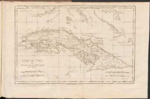
A MAP of / The ISLE of CUBA, / with the / Bahama Islands, Gulf of Florida,
- Standort
-
Deutsches Historisches Museum, Berlin
- Inventarnummer
-
Do 2006/25
- Maße
-
Höhe x Breite: 36,5 x 51,6 cm (Blatt)
Höhe x Breite: 32 x 47 cm (Karte)
Höhe x Breite: 34,8 x 50 cm (Platte)
- Material/Technik
-
Druckfarbe, Papier, Kupferstich, grenzkoloriert
- Klassifikation
-
Kartografie (Gattung)
- Bezug (was)
-
Kuba
Große Antillen
Westindische Inseln
- Ereignis
-
Herstellung
- (wer)
-
Geograph, Stecher, Verleger: Thomas Jefferys (1695)
- (wo)
-
London, Großbritannien und Nordirland
- (wann)
-
um 1775
- Rechteinformation
-
Deutsches Historisches Museum
- Letzte Aktualisierung
-
24.03.2023, 09:31 MEZ
Datenpartner
Dieses Objekt wird bereitgestellt von:
Stiftung Deutsches Historisches Museum. Bei Fragen zum Objekt wenden Sie sich bitte an den Datenpartner.
Stiftung Deutsches Historisches Museum. Bei Fragen zum Objekt wenden Sie sich bitte an den Datenpartner.
Objekttyp
- Küstenkarte
Beteiligte
- Geograph, Stecher, Verleger: Thomas Jefferys (1695)
Entstanden
- um 1775
Ähnliche Objekte (12)
L'Isle De Cuba

De l'Isle de Cuba.
THE ISLAND OF CUBA

The Isle of Wight
The Isle of unrest
The Isle of Caprea
THE ISLE of CAPREA.
A handbook for travellers in Surrey, Hampshire, and the Isle of Wight : with map
A voyage to the Island of Mauritius, (or, Isle of France), the Isle of Bourbon, ...

Isle of Doga
Isle of Wight

Isle of Man
L'Isle De Cuba
De l'Isle de Cuba.
THE ISLAND OF CUBA
The Isle of Wight
The Isle of unrest
The Isle of Caprea
THE ISLE of CAPREA.
A handbook for travellers in Surrey, Hampshire, and the Isle of Wight : with map
A voyage to the Island of Mauritius, (or, Isle of France), the Isle of Bourbon, ...
Isle of Doga
Isle of Wight