Historische Karte
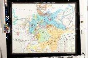
Historische Wandkarte der Staats- und Verwaltungsgrenzen im Deutschen Reich des 19. Jahrhunderts
- Alternative title
-
Deutschland 1815 - 1914
- Location
-
Deutsches Historisches Museum, Berlin
- Inventory number
-
DG 90/7650
- Measurements
-
Höhe x Breite: 205 x 198 cm
- Material/Technique
-
Papier : Leinwand, Holz, gedruckt
- Classification
-
Kartografie (Gattung)
- Subject (what)
-
Geschichte
Deutschland
- Event
-
Herstellung
- (who)
-
Kartograf: Heinrich Hertzberg
Karthograph: Hermann Haack
Bearbeiter: R. Bohnenstaedt
Verlag: Geographische Anstalt Justus Perthes
- (where)
-
Gotha, Deutschland [historisch: Deutsches Reich]
- (when)
-
um 1930
- Rights
-
Deutsches Historisches Museum
- Last update
-
24.03.2023, 9:29 AM CET
Data provider
This object is provided by:
Stiftung Deutsches Historisches Museum. If you have any questions about the object, please contact the data provider.
Stiftung Deutsches Historisches Museum. If you have any questions about the object, please contact the data provider.
Object type
- Historische Karte
Associated
- Kartograf: Heinrich Hertzberg
- Karthograph: Hermann Haack
- Bearbeiter: R. Bohnenstaedt
- Verlag: Geographische Anstalt Justus Perthes
Time of origin
- um 1930
Other Objects (12)
Historische Wandkarte von Deutschland im 19. Jahrhundert
Historische Wandkarte zur Geschichte des Deutschen Reiches

Historische Wandkarte aus der UdSSR zum 1. Weltkrieg

Historische Wandkarte mit der politisch-administrativen Gliederung Deutschlands zwischen 1815 und 1871
Historische Karte des Rheinlandes am Ende des 18. Jahrhunderts mit den Wappen der Fürsten
Historische Karte zum 1. Weltkrieg in Polen

Historisch-politische Karte mit den Wirkungsstätten Ernst Thälmanns

Historische Karte zum Deutsch-Französischen Krieg 1870/71
Historische Karte Deutschlands in den Grenzen von 1937
Historische Landkarte zu Siedlungsbewegungen deutscher Volksgruppen in Geschichte und Gegenwart

Historische Karte zum 1. Weltkrieg (Beilage aus den "Kriegserinnerungen" von Ludendorff)
Fotokopie einer historischen Karte mit dem Grundriss der Stadt Köln im Mittelalter
Historische Wandkarte von Deutschland im 19. Jahrhundert
Historische Wandkarte zur Geschichte des Deutschen Reiches
Historische Wandkarte aus der UdSSR zum 1. Weltkrieg
Historische Wandkarte mit der politisch-administrativen Gliederung Deutschlands zwischen 1815 und 1871
Historische Karte des Rheinlandes am Ende des 18. Jahrhunderts mit den Wappen der Fürsten
Historische Karte zum 1. Weltkrieg in Polen
Historisch-politische Karte mit den Wirkungsstätten Ernst Thälmanns
Historische Karte zum Deutsch-Französischen Krieg 1870/71
Historische Karte Deutschlands in den Grenzen von 1937
Historische Landkarte zu Siedlungsbewegungen deutscher Volksgruppen in Geschichte und Gegenwart
Historische Karte zum 1. Weltkrieg (Beilage aus den "Kriegserinnerungen" von Ludendorff)