Karten / Pläne
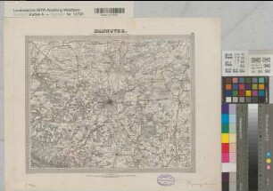
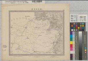
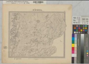
Hannover (Königreich/Provinz) topographische Karte Blatt 54 Hameln 1836-1848 (1878-1889) 1 geogr. Meile = 7,3 cm 29,5 x 36,5 Stich: Karl Jättnig, Hannover; Hermann Bormann; W. Brose; Wild jun. A. Papen, Premier Lieutenant B Nr. 116
- Former reference number
-
B 116
- Further information
-
Ort: Königreich/Prov Hannover
- Context
-
Karten A (Allgemein) >> 1. Topographische Karte, Übersichtskarten >> 1.1. Geographische, topographische Karten
- Holding
-
W 051 Karten A (Allgemein)
- Indexentry place
-
Königreich/Prov Hannover
Hameln, topographische Karte s. Hannover, 1889
Hannover, Königreich, topographische Karte, 1889
- Provenance
-
Sammlungsregistraturbildner
- Date of creation
-
1889
- Other object pages
- Delivered via
- Last update
-
24.06.2025, 2:13 PM CEST
Data provider
This object is provided by:
Landesarchiv Nordrhein-Westfalen. Abteilung Westfalen. If you have any questions about the object, please contact the data provider.
Landesarchiv Nordrhein-Westfalen. Abteilung Westfalen. If you have any questions about the object, please contact the data provider.
Object type
- Karten / Pläne
Associated
- Sammlungsregistraturbildner
Time of origin
- 1889
Other Objects (12)
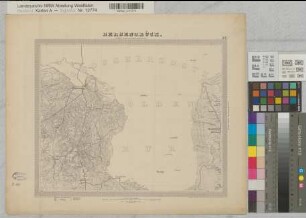
Hannover (Königreich) topographische Karte Blatt 48 Hannover 1836-1848 1 geogr. Meile = 7,3 cm 29,5 x 36,5 Stich: Carl Jättnig; C. Fischer; H. Wild; W. Brose; Wild jun. A. Papen, Premier Lieutenant B Nr. 116a
Hannover (Königreich/trovinz) topographische Karte Blatt 43 Bentheim 1836-1848 (1878-1889) 1 geogr. Meile = 7,3 cm 29,5 x 36,5 Stich: Karl Jättnig, Hannover; Hermann Bormann; W. Brose; Wild jun. A. Papen, Premier Lieutenant B Nr. 116
Hannover (Königreich/Provinz) topographische Karte Blatt 36 Ems-Kanal 1836-1848 (1878-1889) 1 geogr. Meile = 7,3 cm 29,5 x 36,5 Stich: Karl Jättnig, Hannover; Hermann Bormann; W. Brose; Wild jun. A. Papen, Premier Lieutenant B Nr. 116
Hannover (Königreich/Provinz) topographische Karte Blatt 46 Diepenau 1836-1848 (1878-1889) 1 geogr. Meile = 7,3 cm 29,5 x 36,5 Stich: Karl Jättnig, Hannover; Hermann Bormann; W. Brose; Wild jun. A. Papen, Premier Lieutenant B Nr. 116
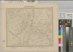
Hannover (Königreich/Provinz) topographische Karte Blatt 59 Polle 1836-1848 (1878-1889) 1 geogr. Meile = 7,3 cm 29,5 x 36,5 Stich: Karl Jättnig, Hannover; Hermann Bormann; W. Brose; Wild jun. A. Papen, Premier Lieutenant B Nr. 116
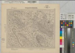
Hannover (Königreich/Provinz) topographische Karte Blatt 55 Hildesheim 1836-1848 (1878-1889) 1 geogr. Meile = 7,3 cm 29,5 x 36,5 Stich: Karl Jättnig, Hannover; Hermann Bormann; W. Brose; Wild jun. A. Papen, Premier Lieutenant B Nr. 116
Hannover (Königreich/Provinz) topographische Karte Blatt 38 Bahrenburg 1836-1848 (1878-1889) 1 geogr. Meile = 7,3 cm 29,5 x 36,5 Stich: Karl Jättnig, Hannover; Hermann Bormann; W. Brose; Wild jun. A. Papen, Premier Lieutenant B Nr. 116
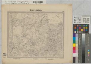
Hannover (Königreich/Provinz) topographische Karte Blatt 29 Harpstedt 1836-1848 (1878-1889) 1 geogr. Meile = 7,3 cm 29,5 x 36,5 Stich: Karl Jättnig, Hannover; Hermann Bormann; W. Brose; Wild jun. A. Papen, Premier Lieutenant B Nr. 116
Hannover (Königreich/Provinz) topographische Karte Blatt 27 Sögel 1836-1848 (1878-1889) 1 geogr. Meile = 7,3 cm 29,5 x 36,5 Stich: Karl Jättnig, Hannover; Hermann Bormann; W. Brose; Wild jun. A. Papen, Premier Lieutenant B Nr. 116
Hannover (Königreich/Provinz) topographische Karte Blatt 37 Bersenbrück 1836-1848 (1878-1889) 1 geogr. Meile = 7,3 cm 29,5 x 36,5 Stich: Karl Jättnig, Hannover; Hermann Bormann; W. Brose; Wild jun. A. Papen, Premier Lieutenant B Nr. 116
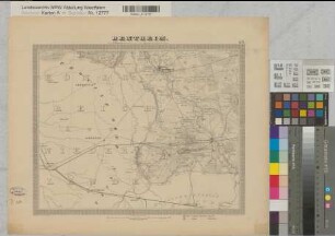
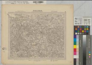
Hannover (Königreich/Provinz) topographische Karte Blatt 39 Nienburg 1836-1848 (1878-1889) 1 geogr. Meile = 7,3 cm 29,5 x 36,5 Stich: Karl Jättnig, Hannover; Hermann Bormann; W. Brose; Wild jun. A. Papen, Premier Lieutenant B Nr. 116
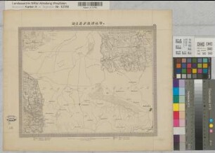
Hannover (Königreich/Provinz) topographische Karte Blatt 30 Verden 1836-1848 (1878-1889) 1 geogr. Meile = 7,3 cm 29,5 x 36,5 Stich: Karl Jättnig, Hannover; Hermann Bormann; W. Brose; Wild jun. A. Papen, Premier Lieutenant B Nr. 116
Hannover (Königreich) topographische Karte Blatt 48 Hannover 1836-1848 1 geogr. Meile = 7,3 cm 29,5 x 36,5 Stich: Carl Jättnig; C. Fischer; H. Wild; W. Brose; Wild jun. A. Papen, Premier Lieutenant B Nr. 116a
Hannover (Königreich/trovinz) topographische Karte Blatt 43 Bentheim 1836-1848 (1878-1889) 1 geogr. Meile = 7,3 cm 29,5 x 36,5 Stich: Karl Jättnig, Hannover; Hermann Bormann; W. Brose; Wild jun. A. Papen, Premier Lieutenant B Nr. 116
Hannover (Königreich/Provinz) topographische Karte Blatt 36 Ems-Kanal 1836-1848 (1878-1889) 1 geogr. Meile = 7,3 cm 29,5 x 36,5 Stich: Karl Jättnig, Hannover; Hermann Bormann; W. Brose; Wild jun. A. Papen, Premier Lieutenant B Nr. 116
Hannover (Königreich/Provinz) topographische Karte Blatt 46 Diepenau 1836-1848 (1878-1889) 1 geogr. Meile = 7,3 cm 29,5 x 36,5 Stich: Karl Jättnig, Hannover; Hermann Bormann; W. Brose; Wild jun. A. Papen, Premier Lieutenant B Nr. 116
Hannover (Königreich/Provinz) topographische Karte Blatt 59 Polle 1836-1848 (1878-1889) 1 geogr. Meile = 7,3 cm 29,5 x 36,5 Stich: Karl Jättnig, Hannover; Hermann Bormann; W. Brose; Wild jun. A. Papen, Premier Lieutenant B Nr. 116
Hannover (Königreich/Provinz) topographische Karte Blatt 55 Hildesheim 1836-1848 (1878-1889) 1 geogr. Meile = 7,3 cm 29,5 x 36,5 Stich: Karl Jättnig, Hannover; Hermann Bormann; W. Brose; Wild jun. A. Papen, Premier Lieutenant B Nr. 116
Hannover (Königreich/Provinz) topographische Karte Blatt 38 Bahrenburg 1836-1848 (1878-1889) 1 geogr. Meile = 7,3 cm 29,5 x 36,5 Stich: Karl Jättnig, Hannover; Hermann Bormann; W. Brose; Wild jun. A. Papen, Premier Lieutenant B Nr. 116
Hannover (Königreich/Provinz) topographische Karte Blatt 29 Harpstedt 1836-1848 (1878-1889) 1 geogr. Meile = 7,3 cm 29,5 x 36,5 Stich: Karl Jättnig, Hannover; Hermann Bormann; W. Brose; Wild jun. A. Papen, Premier Lieutenant B Nr. 116
Hannover (Königreich/Provinz) topographische Karte Blatt 27 Sögel 1836-1848 (1878-1889) 1 geogr. Meile = 7,3 cm 29,5 x 36,5 Stich: Karl Jättnig, Hannover; Hermann Bormann; W. Brose; Wild jun. A. Papen, Premier Lieutenant B Nr. 116
Hannover (Königreich/Provinz) topographische Karte Blatt 37 Bersenbrück 1836-1848 (1878-1889) 1 geogr. Meile = 7,3 cm 29,5 x 36,5 Stich: Karl Jättnig, Hannover; Hermann Bormann; W. Brose; Wild jun. A. Papen, Premier Lieutenant B Nr. 116
Hannover (Königreich/Provinz) topographische Karte Blatt 39 Nienburg 1836-1848 (1878-1889) 1 geogr. Meile = 7,3 cm 29,5 x 36,5 Stich: Karl Jättnig, Hannover; Hermann Bormann; W. Brose; Wild jun. A. Papen, Premier Lieutenant B Nr. 116