Fotografie
Lofer - Landkarte : Landkarte mit Wandergebieten. Aufgenommen am 18. Juli 2011 in Lofer
Landkarte mit Wandergebieten. Aufgenommen am 18. Juli 2011 in Lofer
- Other number(s)
-
df_ge_0028100 (Aufnahmenummer)
71230013 (Dokumentennummer)
- Classification
-
Fotografie (Gattung)
- Subject (what)
-
Dorfansicht
Dorf
Alpen
Kartenausschnitt
Saalachtal
- Subject (where)
-
Lofer (Standort)
- Event
-
Fotografische Aufnahme
- (who)
-
Gerig, Uwe (Fotograf)
- (when)
-
2011
- Rights
-
Bitte beachten Sie die Nutzungsbedingungen der Deutschen Fotothek.
- Last update
-
05.03.2025, 4:18 PM CET
Data provider
This object is provided by:
Deutsche Fotothek. If you have any questions about the object, please contact the data provider.
Deutsche Fotothek. If you have any questions about the object, please contact the data provider.
Object type
- Fotografie
Associated
- Gerig, Uwe (Fotograf)
Time of origin
- 2011
Other Objects (12)

Alpenlandschaft bei Lofer : Alpenlandschaft bei Lofer, aufgenommen am 17. Juli 2011

Alpenlandschaft bei Lofer : Alpenlandschaft bei Lofer, aufgenommen am 17. Juli 2011

Alpenlandschaft bei Lofer : Alpenlandschaft bei Lofer, aufgenommen am 17. Juli 2011
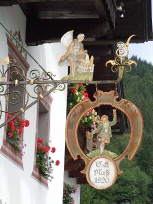
Lofer - Wirtshausschild : Historisches Wirtshausschild. Aufgenommen am 18. Juli 2011 in Lofer
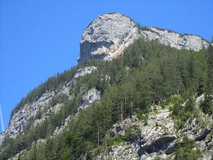
Alpenlandschaft bei Lofer : Alpenlandschaft bei Lofer, aufgenommen am 17. Juli 2011

Alpenlandschaft bei Lofer : Alpenlandschaft bei Lofer, aufgenommen am 17. Juli 2011

Alpenlandschaft bei Lofer : Alpenlandschaft bei Lofer, aufgenommen am 17. Juli 2011

Lofer - Häuser in der Ortsmitte : Aufgenommen am 23. Juli 2011 in Lofer

Lofer - Historisches Wirtshausschild : Wirtshausschild mit Doppeladler. Aufgenommen am 23. Juli 2011 in Lofer

Holzstapel im Wald bei Lofer : Gestapeltes Holz bei Lofer, aufgenommen am 17. Juli 2011
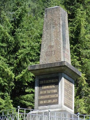
Kriegerdenkmal bei Lofer : Historisches Denkmal für Landesverteidiger bei Lofer, aufgenommen am 17. Juli 2011

Lofer - Geranien am Gasthaus : Fassade mit Blumenschmuck. Aufgenommen am 23. Juli 2011 in Lofer
Alpenlandschaft bei Lofer : Alpenlandschaft bei Lofer, aufgenommen am 17. Juli 2011
Alpenlandschaft bei Lofer : Alpenlandschaft bei Lofer, aufgenommen am 17. Juli 2011
Alpenlandschaft bei Lofer : Alpenlandschaft bei Lofer, aufgenommen am 17. Juli 2011
Lofer - Wirtshausschild : Historisches Wirtshausschild. Aufgenommen am 18. Juli 2011 in Lofer
Alpenlandschaft bei Lofer : Alpenlandschaft bei Lofer, aufgenommen am 17. Juli 2011
Alpenlandschaft bei Lofer : Alpenlandschaft bei Lofer, aufgenommen am 17. Juli 2011
Alpenlandschaft bei Lofer : Alpenlandschaft bei Lofer, aufgenommen am 17. Juli 2011
Lofer - Häuser in der Ortsmitte : Aufgenommen am 23. Juli 2011 in Lofer
Lofer - Historisches Wirtshausschild : Wirtshausschild mit Doppeladler. Aufgenommen am 23. Juli 2011 in Lofer
Holzstapel im Wald bei Lofer : Gestapeltes Holz bei Lofer, aufgenommen am 17. Juli 2011
Kriegerdenkmal bei Lofer : Historisches Denkmal für Landesverteidiger bei Lofer, aufgenommen am 17. Juli 2011