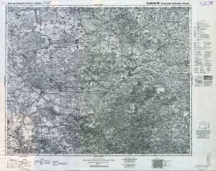
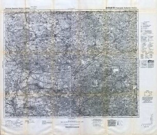
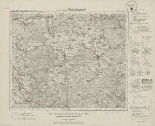
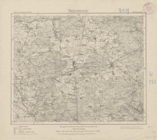
Topographische Karte
Topographische Karte des Gebietes von Finsterwalde-Großenhain-Kamenz
- Alternative title
-
Großblatt 89
Finsterwalde-Großenhain-Kamenz
- Location
-
Deutsches Historisches Museum, Berlin
- Inventory number
-
Do 83/113I
- Measurements
-
Höhe x Breite: 67 x 79,4 cm
- Material/Technique
-
Papier, gedruckt
- Classification
-
Kartografie (Gattung)
- Subject (what)
-
Topographie
- Event
-
Herstellung
- (who)
-
Herausgeber: Reichsamt für Landesaufnahme
- (where)
-
Berlin, Deutschland [historisch: Deutsches Reich]
- (when)
-
1938
- Rights
-
Deutsches Historisches Museum
- Last update
-
24.03.2023, 9:29 AM CET
Data provider
This object is provided by:
Stiftung Deutsches Historisches Museum. If you have any questions about the object, please contact the data provider.
Stiftung Deutsches Historisches Museum. If you have any questions about the object, please contact the data provider.
Object type
- Topographische Karte
Associated
- Herausgeber: Reichsamt für Landesaufnahme
Time of origin
- 1938
Other Objects (12)
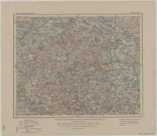
Reichskarte: Großblatt 89 Finsterwalde-Großenhain-Kamenz
Reichskarte: Großblatt 89 Finsterwalde-Großenhain-Kamenz
Blatt 393: Kamenz
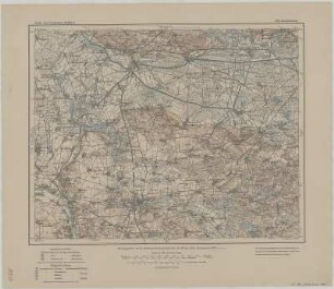
Blatt 392: Großenhain

Großblatt 89 Finsterwalde - Großenhain - Kamenz
Topographische Karte der Alpen
Topographische Specialkarte von Mitteleuropa
Topographische Karte des Erzgebirges
367. Finsterwalde
367. Finsterwalde
Topographische Karte des Kreises Grimmen
Topographische Karte des Kurischen Haffes
Reichskarte: Großblatt 89 Finsterwalde-Großenhain-Kamenz
Reichskarte: Großblatt 89 Finsterwalde-Großenhain-Kamenz
Blatt 393: Kamenz
Blatt 392: Großenhain
Großblatt 89 Finsterwalde - Großenhain - Kamenz
Topographische Karte der Alpen
Topographische Specialkarte von Mitteleuropa
Topographische Karte des Erzgebirges
367. Finsterwalde
367. Finsterwalde
Topographische Karte des Kreises Grimmen