Archivale
Handatlas der neueren Erdbeschreibung über alle Teile der Erde
Enthält u. a.: Karte der Provinz Sachsen.- Königreich Sachsen.
- Reference number
-
68006 - 7
- Former reference number
-
Rep.I.4
- Dimensions
-
Format in cm: 35,5 x 44,5 cm
- Further information
-
Verfasser: Dr. K. Sohr
Beschreibstoff: Papier, schwarz-weiß gedruckt
- Context
-
Karten, Pläne und Atlanten >> 1. Atlanten
- Holding
-
68006 Karten, Pläne und Atlanten
- Date of creation
-
1844
- Other object pages
- Provenance
-
Druck und Verlag C. Flemming, Glogau
- Last update
-
17.06.2025, 7:46 AM CEST
Data provider
This object is provided by:
Archivverbund Stadtarchiv/Staatsfilialarchiv Bautzen. If you have any questions about the object, please contact the data provider.
Archivverbund Stadtarchiv/Staatsfilialarchiv Bautzen. If you have any questions about the object, please contact the data provider.
Object type
- Archivale
Time of origin
- 1844
Other Objects (12)

Vollständiger Hand-Atlas der neueren Erdbeschreibung über alle Theile der Erde
![Vollständiger Universal - Handatlas der neueren Erdbeschreibung über alle theile der Erde [...]](/assets/placeholder/searchResultMediaNoDigitisedMedia.png)
Vollständiger Universal - Handatlas der neueren Erdbeschreibung über alle theile der Erde [...]
Supplementband zum Handatlas der neueren Erdbeschreibung
Vollständiger Hand-Atlas der neueren Erdbeschreibung über alle Theile der Erde in 80 Blättern [Sohr-Berghaus Hand-Atlas]
Supplementband zum Hand-Atlas der neueren Erdbeschreibung [Sohr-Berghaus Hand-Atlas]
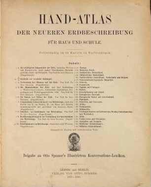
Hand-Atlas der neueren Erdbeschreibung für Haus und Schule : Beigabe zu Otto Spamer's Illustrirtem Konversations-Lexikon
Neueer Handatlas über alle Teile der Erde

Neuer Handatlas über alle Theile der Erde
![Neuer Handatlas [über alle Theile der Erde]](/assets/placeholder/searchResultMediaUnknown.png)
Neuer Handatlas [über alle Theile der Erde]
Neuer Handatlas über alle Theile der Erde
Neuer Handatlas über alle Teile der Erde
Handatlas über alle Theile der Erde und über das Weltgebäude
Vollständiger Hand-Atlas der neueren Erdbeschreibung über alle Theile der Erde
Vollständiger Universal - Handatlas der neueren Erdbeschreibung über alle theile der Erde [...]
Supplementband zum Handatlas der neueren Erdbeschreibung
Vollständiger Hand-Atlas der neueren Erdbeschreibung über alle Theile der Erde in 80 Blättern [Sohr-Berghaus Hand-Atlas]
Supplementband zum Hand-Atlas der neueren Erdbeschreibung [Sohr-Berghaus Hand-Atlas]
Hand-Atlas der neueren Erdbeschreibung für Haus und Schule : Beigabe zu Otto Spamer's Illustrirtem Konversations-Lexikon
Neueer Handatlas über alle Teile der Erde
Neuer Handatlas über alle Theile der Erde
Neuer Handatlas [über alle Theile der Erde]
Neuer Handatlas über alle Theile der Erde
Neuer Handatlas über alle Teile der Erde