- Location
-
München, Bayerische Staatsbibliothek -- 2 Mapp. 155
- Dimensions
-
54 x 41 cm
- Extent
-
1 Kt.
- Language
-
Französisch
- Notes
-
Kupferstich
Maßstab in graph. Form (Mille Pas Geometriques ou Milles d'Italie, Lieues Communes d'Allemagne)
- Bibliographic citation
-
Sanson, Guillaume: Atlas Nouveau A L'Usage De Monseigneur Le Duc De Bourgogne ; 64
- Series
-
Sanson, Guillaume: Atlas Nouveau A L'Usage De Monseigneur Le Duc De Bourgogne; 64
- Keyword
-
Verwaltungsgrenze
Hochstift Münster (Westf)
Grafschaft Bentheim
- Event
-
Veröffentlichung
- (where)
-
Paris [erschienen in Amsterdam]
- (who)
-
H. Iaillot [erschienen bei Pierre Mortier]
- (when)
-
1692 [erschienen ca. 1710]
- Contributor
- URN
-
urn:nbn:de:bvb:12-bsb00035766-4
- Last update
-
27.11.2025, 8:48 AM CET
Data provider
This object is provided by:
Bayerische Staatsbibliothek. If you have any questions about the object, please contact the data provider.
Bayerische Staatsbibliothek. If you have any questions about the object, please contact the data provider.
Object type
- Altkarte
Associated
- Sanson, Guillaume (Sonstige)
- Jaillot, Alexis Hubert (Sonstige)
- H. Iaillot [erschienen bei Pierre Mortier]
Time of origin
- 1692 [erschienen ca. 1710]
Other Objects (12)

Niederstift Münster und Grafschaft Bentheim. "Basse partie de l´Evesché de Munster et le Comté de Benthem" "Tiré des mémoires . . .par le Sr Sanson, Gérgr. ord. du Roi. A Paris, chez H. Jaillot . . . "
Niederstift Münster und Grafschaft Bentheim. "Basse partie de l´Evesché de Munster et le Comté de Benthem" "Tiré des mémoires . . .par le Sr Sanson, Géogr. ord. du Roi. A Paris, chez H. Jaillot . . . "

Münster, Niederstift Basse partie de l'evesché de Munster et le comté de Benthem Übersichtskarte 1673 2 dt. Meilen = 5 cm 43 x 57 Stich Sanson H. Jaillot, Paris Kartusche B 330 bzw. Ba I,9
Affaire Benthem : 1984 - 1985 = Benthem case
Vallée de Munster
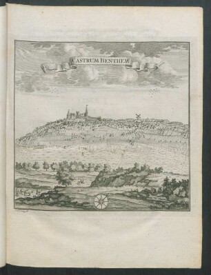
Castrum Benthem
De Vrede van Munster
L'Eveché de Munster

Plan De La Ville De Munster
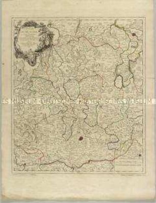
Grand Atlas . Bl. 12 (Münster, Oldenburg, Osnabrück, Ostfriesland): Contenant une Partie inferieure de l'Evêché de Munster, une Partie du Duche D'Oldenbourg, de l'Evêché d'Osnabruck, de Friesland Orientale de Gröningen et d'Over-Yssel, les Comtés de Benthem de Lingen et et
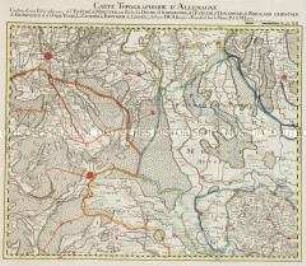
Bl. LXI: L'Eveché de Munster Le Comté de Bentheim, Tecklenbourg Stenford Lingen, Diepholtz Delmenhorst, Ritberg etc.

Henricus Ludolphus Benthem
Niederstift Münster und Grafschaft Bentheim. "Basse partie de l´Evesché de Munster et le Comté de Benthem" "Tiré des mémoires . . .par le Sr Sanson, Gérgr. ord. du Roi. A Paris, chez H. Jaillot . . . "
Niederstift Münster und Grafschaft Bentheim. "Basse partie de l´Evesché de Munster et le Comté de Benthem" "Tiré des mémoires . . .par le Sr Sanson, Géogr. ord. du Roi. A Paris, chez H. Jaillot . . . "
Münster, Niederstift Basse partie de l'evesché de Munster et le comté de Benthem Übersichtskarte 1673 2 dt. Meilen = 5 cm 43 x 57 Stich Sanson H. Jaillot, Paris Kartusche B 330 bzw. Ba I,9
Affaire Benthem : 1984 - 1985 = Benthem case
Vallée de Munster
Castrum Benthem
De Vrede van Munster
L'Eveché de Munster
Plan De La Ville De Munster
Grand Atlas . Bl. 12 (Münster, Oldenburg, Osnabrück, Ostfriesland): Contenant une Partie inferieure de l'Evêché de Munster, une Partie du Duche D'Oldenbourg, de l'Evêché d'Osnabruck, de Friesland Orientale de Gröningen et d'Over-Yssel, les Comtés de Benthem de Lingen et et
Bl. LXI: L'Eveché de Munster Le Comté de Bentheim, Tecklenbourg Stenford Lingen, Diepholtz Delmenhorst, Ritberg etc.