Umgebungskarten
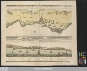
Topographica Repraesentatio Barbarici Portus et Urbis Munitae Oran. Mit einer Ansicht: Prospect von der Küste um Oran
- Alternativer Titel
-
TOPOGRAPHICA REPRAESENTATIO BARBARICI PORTVS et VRBIS MVNITAE ORAN VNA CVM / adjacente ora maritima, quae sita est in Regno TELENSIN, ab HISPANIS jam primum Anno CI)I)IX. / et posteaquam Anno MDCCVIII. MAVRIS, Reipublicae nimirum Algiericae rursus cessit, hoc Anno denuo / expugnata; accuratissime ita secundum Ichno-et Scenographiam delineata á CHRISTIANO GEPHARTO,
- Standort
-
Deutsches Historisches Museum, Berlin
- Inventarnummer
-
Do 2006/311
- Maße
-
Höhe x Breite: 49,5 x 61,5 cm (Blatt)
Höhe x Breite: 21,3 x 53,3 cm (Karte)
- Material/Technik
-
Druckfarbe, Papier, Kupferstich, koloriert
- Klassifikation
-
Kartografie (Gattung)
- Bezug (was)
-
Oran
Algerien
- Ereignis
-
Herstellung
- (wer)
-
Kartograf: Christian Gephart
Verlag: Homannsche Erben
- (wo)
-
Nürnberg, Deutschland
- (wann)
-
1732
- Rechteinformation
-
Deutsches Historisches Museum
- Letzte Aktualisierung
-
24.03.2023, 09:30 MEZ
Datenpartner
Dieses Objekt wird bereitgestellt von:
Stiftung Deutsches Historisches Museum. Bei Fragen zum Objekt wenden Sie sich bitte an den Datenpartner.
Stiftung Deutsches Historisches Museum. Bei Fragen zum Objekt wenden Sie sich bitte an den Datenpartner.
Objekttyp
- Umgebungskarten
Beteiligte
- Kartograf: Christian Gephart
- Verlag: Homannsche Erben
Entstanden
- 1732
Ähnliche Objekte (12)

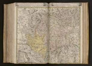
Repraesentatio Geographica Circuli Egerani
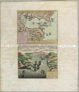
Topographica Repræsentatio Barbarici Portvs et Vrbis Mvnitæ Oran : Vna Cvm adjacente ora maritima, quæ sita est in Regno Telensin, ab Hispanis jam primum Anno MDIX et posteaquam Anno MDCCVIII Mavris, Reipublicæ nimirum Algiericæ rursus cessit, hoc Anno denuo expugnata
Atlas Regni Bohemiae: Repraesentatio Geographica Circuli Egerani, nec non Elnbogensis / Carte du Territoire d'Egra, & du Cercle d'Elnbogue
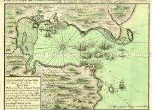
Portus Pulchri / Scenographia Portus pulchri
Ducatus Westphaliae nova repraesentatio geographica
#Portus Pulchri in Isthmo Panamensi/ Grundriß der Stadt Portobelo, des Hafens und der Forts 1740
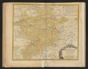
Ducatvs Westphaliae nova repraesentatio geographica
Repraesentatio Geographica Circvli Egerani, nec non Elnbogensis : in quo simul viae Egeranae in Thermas Carolinas distincta delineatio conspicitur
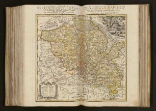
Geographische Verzeichnung des Bvdissinischen Creises in dem Marggrafthum Ober Lavsitz

Tabula Geographica Totam Borussiam ut et Districtum Notecensem. Mit einer Nebenkarte: Charte welche den Netz District vorstellet
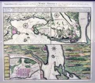
Pläne der kanadischen Städte Louisburg, Québec und Halifax unter französischer und englischer Herrschaft
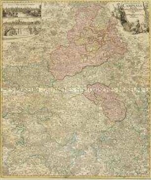
Tabula Geographica Campaniae. Mit zwei Nebenkarten: Reims und Troyes
Repraesentatio Geographica Circuli Egerani
Topographica Repræsentatio Barbarici Portvs et Vrbis Mvnitæ Oran : Vna Cvm adjacente ora maritima, quæ sita est in Regno Telensin, ab Hispanis jam primum Anno MDIX et posteaquam Anno MDCCVIII Mavris, Reipublicæ nimirum Algiericæ rursus cessit, hoc Anno denuo expugnata
Atlas Regni Bohemiae: Repraesentatio Geographica Circuli Egerani, nec non Elnbogensis / Carte du Territoire d'Egra, & du Cercle d'Elnbogue
Portus Pulchri / Scenographia Portus pulchri
Ducatus Westphaliae nova repraesentatio geographica
#Portus Pulchri in Isthmo Panamensi/ Grundriß der Stadt Portobelo, des Hafens und der Forts 1740
Ducatvs Westphaliae nova repraesentatio geographica
Repraesentatio Geographica Circvli Egerani, nec non Elnbogensis : in quo simul viae Egeranae in Thermas Carolinas distincta delineatio conspicitur
Geographische Verzeichnung des Bvdissinischen Creises in dem Marggrafthum Ober Lavsitz
Tabula Geographica Totam Borussiam ut et Districtum Notecensem. Mit einer Nebenkarte: Charte welche den Netz District vorstellet
Pläne der kanadischen Städte Louisburg, Québec und Halifax unter französischer und englischer Herrschaft