Altkarte | Atlas
Sac. Imperii Romano Germanici geographica descriptio : Teutschland mit angränzenden Königreich- und Provinzien ... in 32 ... Tabellen vorgestelt ; sambt einem Vorbericht und Anzeig aller darinn benahmsten Königreich ... Fürstenthumer ...
- Alternative title
-
Teutschland zu bequemen Gebrauch in 32 geographischen Tabellen vorgestelt
Sacri Imperii Romano Germanici geographica descriptio
- Location
-
Regensburg, Staatliche Bibliothek -- 999/Hist.pol.294
- Extent
-
[19] Bl., [35] Doppelbl., [30] Bl.
- Notes
-
überwiegend Kt.
NT: Teutschland zu bequemen Gebrauch in 32 geographischen Tabellen vorgestelt
- Keyword
-
Geschichte -1805
Deutschland
- Event
-
Veröffentlichung
- (where)
-
Augspurg
- (who)
-
Bodenehr
- (when)
-
1682
- Contributor
- URN
-
urn:nbn:de:bvb:12-bsb11095430-8
- Last update
-
27.11.2025, 8:47 AM CET
Data provider
This object is provided by:
Bayerische Staatsbibliothek. If you have any questions about the object, please contact the data provider.
Bayerische Staatsbibliothek. If you have any questions about the object, please contact the data provider.
Object type
- Altkarte
- Atlas
Associated
- Bodenehr, Johann Georg (Sonstige)
- Bodenehr
Time of origin
- 1682
Other Objects (12)

Provinciarum Europae geographica descriptio : Europa mit angrentzenden Welt-Theilen ... in 32 ... Tabellen vorgestellet ; sambt einem Vorbericht, und kurtzen Entwurff der Grentzen ...
![ChurFürsten und Hertzoge zu Bayern des Wittelspachischen Stammes von A[nn]o. 1150 Bis Jetzo](https://iiif.deutsche-digitale-bibliothek.de/image/2/b3e8d379-ac79-4aa0-87bb-9cbb7755929d/full/!306,450/0/default.jpg)
ChurFürsten und Hertzoge zu Bayern des Wittelspachischen Stammes von A[nn]o. 1150 Bis Jetzo
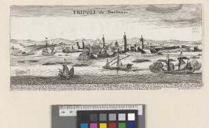
Tripoli di Barbaria
![Typus Sveviae in seqq. LVI tabulas divisae : provinciarum Sveviae geogr[aphica] descriptio; Schwaben](https://iiif.deutsche-digitale-bibliothek.de/image/2/2ea3fd74-352b-42b1-b995-d1e028766961/full/!306,450/0/default.jpg)
Typus Sveviae in seqq. LVI tabulas divisae : provinciarum Sveviae geogr[aphica] descriptio; Schwaben
![Statt u[nd] Schloss vo[n] Tunis](https://iiif.deutsche-digitale-bibliothek.de/image/2/c1081762-651b-4722-92a0-259e25ba3cae/full/!306,450/0/default.jpg)
Statt u[nd] Schloss vo[n] Tunis
![Könige in Polen des Piastisch-Iagelon- und Wasischen Stammens [!] &ca von A° 1000 bis Jetzo](https://iiif.deutsche-digitale-bibliothek.de/image/2/9e0e1e86-496f-4835-9cda-a9ef3653534e/full/!306,450/0/default.jpg)
Könige in Polen des Piastisch-Iagelon- und Wasischen Stammens [!] &ca von A° 1000 bis Jetzo

Eigentlicher Abriß Und Beschreibung Des kostbaren Feuer-Wercks/ Welches Bey Ihro Königl. Maj. in Pohlen/ und Churfl. Durchl. zu Sachsen ... Anwesenheit in Dreßden/ Anno 1699. den 13. Novembr. ... verbrennet worden
![Augustus ex Polonia redux : (Glück) wünsch(end)er Zuruff (al)s Ihro (König)liche Majestaet aus Dero (König)reich (Polen) ... zu (vollk)om[m]ener Freude des (königlich)en (Feste)s (Sach)sen in Dero (Re)sidentz(stadt Dresden wieder)um (retournier)ten ...](https://iiif.deutsche-digitale-bibliothek.de/image/2/c5e44115-ebec-4040-8d66-392c08d1157f/full/!306,450/0/default.jpg)
Augustus ex Polonia redux : (Glück) wünsch(end)er Zuruff (al)s Ihro (König)liche Majestaet aus Dero (König)reich (Polen) ... zu (vollk)om[m]ener Freude des (königlich)en (Feste)s (Sach)sen in Dero (Re)sidentz(stadt Dresden wieder)um (retournier)ten ...

Besonderer Einfall, von einer Vniuersal-Sonnen-Uhr, So, nebst denen gewöhnlichen Stunden, auch die eintzelen Minuten, ohne mühsame Theilung, deutlich und genau zeigen, und doch die Grösse einer Sack- oder Taschen-Uhr nicht viel übertreffen soll ...

Die Churfürstlich Brandenburgisch nun Königlich Preussische Residenz Statt : Berlin und Cölln an der Spree sampt Fridrichswerder und Dorotheenstatt

Architectura von Vestungen, wie solche zu unsern Zeiten, an Städten, Schlössern & Claußen ... mögen erbauet ... werden, 1.

Augustae Beichlingiorum Origines : Aulae Saxonum Augustae Regiaeqve Polonorum Magno Cancellario atqve Sanctiori Senatori, Illustrissimo Domino, Domino Wolfgango-Dieterico S. I. R. Comiti Beichlingio, Dominii perincluti Hoyersvverdensis Domino, Heroi, qvà datum est Summo S.
Provinciarum Europae geographica descriptio : Europa mit angrentzenden Welt-Theilen ... in 32 ... Tabellen vorgestellet ; sambt einem Vorbericht, und kurtzen Entwurff der Grentzen ...
ChurFürsten und Hertzoge zu Bayern des Wittelspachischen Stammes von A[nn]o. 1150 Bis Jetzo
Tripoli di Barbaria
Typus Sveviae in seqq. LVI tabulas divisae : provinciarum Sveviae geogr[aphica] descriptio; Schwaben
Statt u[nd] Schloss vo[n] Tunis
Könige in Polen des Piastisch-Iagelon- und Wasischen Stammens [!] &ca von A° 1000 bis Jetzo
Eigentlicher Abriß Und Beschreibung Des kostbaren Feuer-Wercks/ Welches Bey Ihro Königl. Maj. in Pohlen/ und Churfl. Durchl. zu Sachsen ... Anwesenheit in Dreßden/ Anno 1699. den 13. Novembr. ... verbrennet worden
Augustus ex Polonia redux : (Glück) wünsch(end)er Zuruff (al)s Ihro (König)liche Majestaet aus Dero (König)reich (Polen) ... zu (vollk)om[m]ener Freude des (königlich)en (Feste)s (Sach)sen in Dero (Re)sidentz(stadt Dresden wieder)um (retournier)ten ...
Besonderer Einfall, von einer Vniuersal-Sonnen-Uhr, So, nebst denen gewöhnlichen Stunden, auch die eintzelen Minuten, ohne mühsame Theilung, deutlich und genau zeigen, und doch die Grösse einer Sack- oder Taschen-Uhr nicht viel übertreffen soll ...
Die Churfürstlich Brandenburgisch nun Königlich Preussische Residenz Statt : Berlin und Cölln an der Spree sampt Fridrichswerder und Dorotheenstatt
Architectura von Vestungen, wie solche zu unsern Zeiten, an Städten, Schlössern & Claußen ... mögen erbauet ... werden, 1.