- Alternative title
-
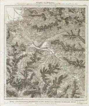
HINTER INDIEN / nebst den / HINTERINDISCHEN INSELN / entworfen und gezeichnet im Jahre 1826
- Location
-
Deutsches Historisches Museum, Berlin
- Inventory number
-
Do 2006/268
- Measurements
-
Höhe x Breite: 57,4 x 70,6 cm (Blatt)
Höhe x Breite: 34,2 x 52 cm (Karte)
Höhe x Breite: 51,8 x 58 cm (Platte)
- Material/Technique
-
Papier, Lithographie
- Classification
-
Kartografie (Gattung)
- Subject (what)
-
Asien
Hinterindien
Südostasien
- Event
-
Herstellung
- (who)
-
Geograph: Karl Ferdinand Weiland
Verlag: Geographisches Institut Weimar
- (where)
-
Weimar, Deutschland
- (when)
-
1840
- Rights
-
Deutsches Historisches Museum
- Last update
-
24.03.2023, 9:29 AM CET
Data provider
This object is provided by:
Stiftung Deutsches Historisches Museum. If you have any questions about the object, please contact the data provider.
Stiftung Deutsches Historisches Museum. If you have any questions about the object, please contact the data provider.
Object type
- Regionalkarte
Associated
- Geograph: Karl Ferdinand Weiland
- Verlag: Geographisches Institut Weimar
Time of origin
- 1840
Other Objects (12)
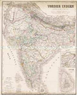
Karte von Indien

Karte von Schwedisch Pommern und der Insel Rügen
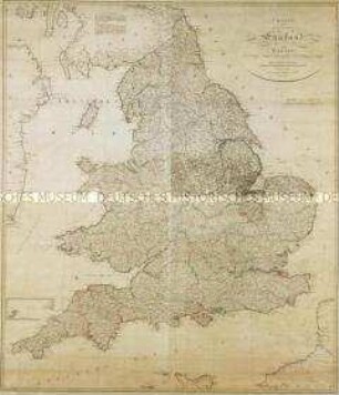
Charte von England und Wallis. Mit einer Nebenkarte (Insel Scilly)
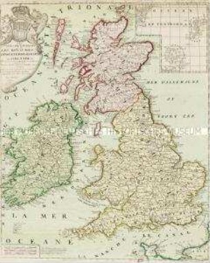
Les Isles Britanniques. Mit einer Nebenkarte: Orkney und Shetland Inseln
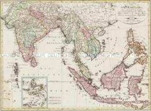
Charte von Ostindien dies= und jenseits des Ganges. Mit einer Nebenkarte: Die Moluckischen Inseln

Neueste und Volstaendige Karte von gantz Elsas nebst den angraenzenden Provinzen

Charte welche die Grafschaften Hennegau und Namur nebst der Herrschaft Doornick vorstellet

Schleswig, nebst einem Theile v. Jütland u. Fünen. Mit einer Nebenkarte: FEHMERN
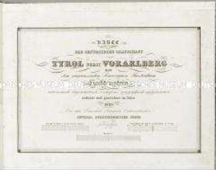
Karte der Gefürsteten Grafschaft Tyrol nebst Vorarlberg und dem angrenzenden Souverainen Fürstenthum Liechtenstein

Tabula Geographica Totam Borussiam ut et Districtum Notecensem. Mit einer Nebenkarte: Charte welche den Netz District vorstellet
Charte von Schwaben No. 60

Holstein, Lauenburg, Hamburg u. Lübeck
Karte von Indien
Karte von Schwedisch Pommern und der Insel Rügen
Charte von England und Wallis. Mit einer Nebenkarte (Insel Scilly)
Les Isles Britanniques. Mit einer Nebenkarte: Orkney und Shetland Inseln
Charte von Ostindien dies= und jenseits des Ganges. Mit einer Nebenkarte: Die Moluckischen Inseln
Neueste und Volstaendige Karte von gantz Elsas nebst den angraenzenden Provinzen
Charte welche die Grafschaften Hennegau und Namur nebst der Herrschaft Doornick vorstellet
Schleswig, nebst einem Theile v. Jütland u. Fünen. Mit einer Nebenkarte: FEHMERN
Karte der Gefürsteten Grafschaft Tyrol nebst Vorarlberg und dem angrenzenden Souverainen Fürstenthum Liechtenstein
Tabula Geographica Totam Borussiam ut et Districtum Notecensem. Mit einer Nebenkarte: Charte welche den Netz District vorstellet
Charte von Schwaben No. 60