Karten / Pläne
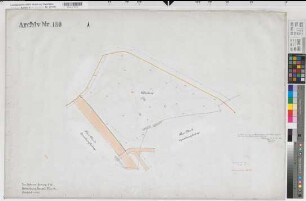
Castrop-Rauxel (Castrop-Rauxel) vom Amt Castrop zur Stadt Castrop-Rauxel Verwaltungskarte 1996 ca 1 : 30 000 54 x 77 farb. Druck Vermessungsamt Castrop-Rauxel
- Reference number
-
W 051, 31385
- Further information
-
Ort: Castrop-Rauxel, Castrop-Rauxel
- Context
-
Karten A (Allgemein) >> 4. Verwaltung >> 4.1. Verwaltungskarten
- Holding
-
W 051 Karten A (Allgemein)
- Indexentry place
-
Castrop-Rauxel, Castrop-Rauxel
Castrop-Rauxel, Verwaltungskarte, 1996
- Provenance
-
Sammlungsregistraturbildner
- Date of creation
-
1996
- Other object pages
- Delivered via
- Zugangsbeschränkungen
-
Allgemeine Schutzfrist nach Aktenschluss nach § 7 Abs. 1 ArchivG NRW: Für die Nutzung gesperrt bis 2026
- Last update
-
24.06.2025, 1:31 PM CEST
Data provider
This object is provided by:
Landesarchiv Nordrhein-Westfalen. Abteilung Westfalen. If you have any questions about the object, please contact the data provider.
Landesarchiv Nordrhein-Westfalen. Abteilung Westfalen. If you have any questions about the object, please contact the data provider.
Object type
- Karten / Pläne
Associated
- Sammlungsregistraturbildner
Time of origin
- 1996
Other Objects (12)

Castrop-Rauxel
Castrop(-Rauxel)
Castrop-Rauxel
Castrop-Rauxel
Castrop-Rauxel
Castrop-Rauxel, Bahnhofstraße 70, Polizeistation Castrop-Rauxel, Lageplan

Castrop-Rauxel (Castrop-Rauxel) Höhenschichtenkarte (1979) 1990 1 : 15 000 86 x 66 farb. Druck: Vermessungsamt Castrop-Rauxel
Castrop-Rauxel, Bahnhofstraße 60, Polizeidienstgebäude Castrop-Rauxel, Erdgeschoss, Grundriss
Castrop-Rauxel, Bahnhofstraße 60, Polizeidienstgebäude Castrop-Rauxel, Obergeschoss, Grundriss
Castrop (Castrop-Rauxel), Zusammenlegung Castrop, Rauxel Flur 14
Castrop-Rauxel, Stadtplan
Amtsgericht Castrop-Rauxel
Castrop-Rauxel
Castrop(-Rauxel)
Castrop-Rauxel
Castrop-Rauxel
Castrop-Rauxel
Castrop-Rauxel, Bahnhofstraße 70, Polizeistation Castrop-Rauxel, Lageplan
Castrop-Rauxel (Castrop-Rauxel) Höhenschichtenkarte (1979) 1990 1 : 15 000 86 x 66 farb. Druck: Vermessungsamt Castrop-Rauxel
Castrop-Rauxel, Bahnhofstraße 60, Polizeidienstgebäude Castrop-Rauxel, Erdgeschoss, Grundriss
Castrop-Rauxel, Bahnhofstraße 60, Polizeidienstgebäude Castrop-Rauxel, Obergeschoss, Grundriss
Castrop (Castrop-Rauxel), Zusammenlegung Castrop, Rauxel Flur 14
Castrop-Rauxel, Stadtplan