Bilder
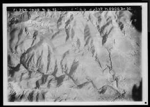
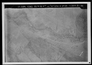
Übersicht über das Gelände südwestlich von Jericho mit Wadi el-Kelt, Jerusalem-Straße, Nebi Musa-Straße und Eintritt des Wadi Medbah Ajjad in die Jordan-Ebene, südöstliche Fortsetzung von 1042
- Reference number
-
BS Pal., BayHStA, BS Pal. 1043
- Language of the material
-
ger
- Notes
-
*
- Further information
-
Medium: A = Analoges Archivalie
- Context
-
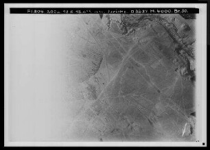
Bildsammlung Palästina >> Bildsammlung Palästina >> Jordantal >> Westlich vom Jordan: Von el-Machruk bis Jericho
- Holding
-
BS Pal. Bildsammlung Palästina
- Date of creation
-
1. August 1918
- Other object pages
- Last update
-
03.04.2025, 1:35 PM CEST
Data provider
This object is provided by:
Bayerisches Hauptstaatsarchiv. If you have any questions about the object, please contact the data provider.
Bayerisches Hauptstaatsarchiv. If you have any questions about the object, please contact the data provider.
Object type
- Fotos und Bilder
Time of origin
- 1. August 1918
Other Objects (12)
![Wadi el-kelt [Wadi Kelt]](https://iiif.deutsche-digitale-bibliothek.de/image/2/2c2b61bf-137c-4ee5-be08-529ca1bedee1/full/!306,450/0/default.jpg)
Wadi el-kelt [Wadi Kelt]

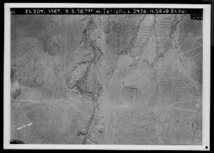
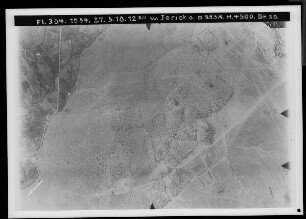
Westlich von Jericho: Wadi el-Kelt, Jerusalem-Straße
Westlich von Jericho: Wadi el-Kelt, Jerusalem-Straße
Westlich von Jericho: Wadi el-Kelt, Jerusalem-Straße
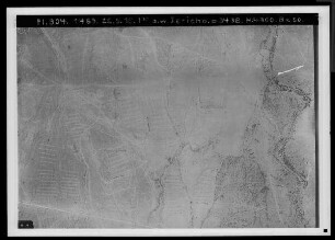
Westlich von Jericho: Wadi el-Kelt, Straße nach Nebi Musa
Westlich von Jericho: Wadi el-Kelt, Straße nach Nebi Musa
Westlich von Jericho: Wadi el-Kelt, Straße nach Nebi Musa
Westlich von Jericho: Wadi el-Kelt, Straße nach Nebi Musa
Westlich von Jericho: Wadi el-Kelt, Straße nach Nebi Musa
Westlich von Jericho: Wadi el-Kelt, Straße nach Nebi Musa
Westlich von Jericho: Wadi el-Kelt, Straße nach Nebi Musa
Westlich von Jericho: Wadi el-Kelt, Straße nach Nebi Musa
Wadi el-kelt [Wadi Kelt]
Westlich von Jericho: Wadi el-Kelt, Jerusalem-Straße
Westlich von Jericho: Wadi el-Kelt, Jerusalem-Straße
Westlich von Jericho: Wadi el-Kelt, Jerusalem-Straße
Westlich von Jericho: Wadi el-Kelt, Straße nach Nebi Musa
Westlich von Jericho: Wadi el-Kelt, Straße nach Nebi Musa
Westlich von Jericho: Wadi el-Kelt, Straße nach Nebi Musa
Westlich von Jericho: Wadi el-Kelt, Straße nach Nebi Musa
Westlich von Jericho: Wadi el-Kelt, Straße nach Nebi Musa
Westlich von Jericho: Wadi el-Kelt, Straße nach Nebi Musa
Westlich von Jericho: Wadi el-Kelt, Straße nach Nebi Musa
Westlich von Jericho: Wadi el-Kelt, Straße nach Nebi Musa
Wadi el-kelt [Wadi Kelt]
Westlich von Jericho: Wadi el-Kelt, Jerusalem-Straße
Westlich von Jericho: Wadi el-Kelt, Jerusalem-Straße
Westlich von Jericho: Wadi el-Kelt, Jerusalem-Straße
Westlich von Jericho: Wadi el-Kelt, Straße nach Nebi Musa
Westlich von Jericho: Wadi el-Kelt, Straße nach Nebi Musa
Westlich von Jericho: Wadi el-Kelt, Straße nach Nebi Musa
Westlich von Jericho: Wadi el-Kelt, Straße nach Nebi Musa
Westlich von Jericho: Wadi el-Kelt, Straße nach Nebi Musa
Westlich von Jericho: Wadi el-Kelt, Straße nach Nebi Musa
Westlich von Jericho: Wadi el-Kelt, Straße nach Nebi Musa