- Reference number
-
P 23, 1
- Dimensions
-
20,5 x 29 cm
- Further information
-
Identifikation (Karte/Plan): Gesamtwerk: Geographisch Handtbuch ; 22
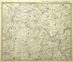
Identifikation (Karte/Plan): Originaltitel: FRANCIA ORIENTALIS, VULGO FRANCONIA, A FRANCO QUODAM EORUM DUCE ORTA CREDITUR GENS ipsa viribus potens est, ac multa nobilate pollens, fallax et astuta, laborum patiens, vinetis collendis uterque sexus incumbit, nec cuiquam otioso esse conceditur
Identifikation (Karte/Plan): Inhaltliche Beschreibung: mit Bildnis Bischof Julius von Würzburg
Herstellerangaben: Erscheinungsort: Colon[ia] Agrip[pina]//Köln
Weitere Angaben (Karte/Plan): Maßstab: [ca. 1:700.000]
Weitere Angaben (Karte/Plan): Ausführung: Papier, Schwarzdruck
Weitere Angaben (Karte/Plan): Blattzahl: 1
Vermerke: Deskriptoren: Deutschland (Süd) / Franken
Vermerke: Deskriptoren: Julius (Würzburg, Bischof, 1573-1617) = Echter v. Mespelbrunn, Julius
Vermerke: Deskriptoren: Rotenhan, Sebastian von
Vermerke: Deskriptoren: Bussemacher, Johann
- Context
-
Karten Herrschaft Schlitz >> Deutsches Reich >> Teile des Deutschen Reichs >> Bayern und Franken
- Holding
-
P 23 Karten Herrschaft Schlitz
- Creator
-
Autore Sebastiano a Rotenhan / Johan Buchsemecher [= Bussemacher] excudit
- Date of creation
-
1592
- Other object pages
- Former provenance
-
Herrschaft Schlitz
- Rights
-
Es gelten die Nutzungsbedingungen der Staatsarchive in Hessen.
- Last update
-
03.09.2022, 4:40 AM CEST
Data provider
This object is provided by:
Hessisches Staatsarchiv Darmstadt. If you have any questions about the object, please contact the data provider.
Hessisches Staatsarchiv Darmstadt. If you have any questions about the object, please contact the data provider.
Object type
- Karte/Plan
Associated
- Autore Sebastiano a Rotenhan / Johan Buchsemecher [= Bussemacher] excudit
Time of origin
- 1592
Other Objects (12)

Das Herzogtum Ostfranken in seine Gaue eingeteilt.
Karte von Franken
Karte von Franken
Karte der Grafschaft Giech in Franken
Karte von Ost-Thüringen
Gliederungsentwürfe für ein Werk "Erläutertes Ost-Franken".
Karte von Franken mit Marschrouten der preussischen Armee unter Prinz Heinrich von Preußen (Siebenjähriger Krieg)
Karte der Postleitbezirke in Ost-Hessen, Thüringen, Sachsen-Anhalt und Südost-Niedersachsen
WHK 21 Österreichischer Sukzessionskrieg 1740-1748 bis zum Aachener Frieden: Karte der Kriegsschauplätze in Bayern und Franken, 1740
. Geologische Karte von Preußen [Teile des Kartenwerks]: Blatt Frankfurt a.M.(Ost)-Offenbach
. Geologische Karte von Preußen [Teile des Kartenwerks]: Blatt Frankfurt a.M. (Ost)-Offenbach (Duplikat)
Karte des westlichen Russlands mit Polen und den preußischen Provinzen Schlesien, Posen, Ost- und Westpreußen
Das Herzogtum Ostfranken in seine Gaue eingeteilt.
Karte von Franken
Karte von Franken
Karte der Grafschaft Giech in Franken
Karte von Ost-Thüringen
Gliederungsentwürfe für ein Werk "Erläutertes Ost-Franken".
Karte von Franken mit Marschrouten der preussischen Armee unter Prinz Heinrich von Preußen (Siebenjähriger Krieg)
Karte der Postleitbezirke in Ost-Hessen, Thüringen, Sachsen-Anhalt und Südost-Niedersachsen
WHK 21 Österreichischer Sukzessionskrieg 1740-1748 bis zum Aachener Frieden: Karte der Kriegsschauplätze in Bayern und Franken, 1740
. Geologische Karte von Preußen [Teile des Kartenwerks]: Blatt Frankfurt a.M.(Ost)-Offenbach
. Geologische Karte von Preußen [Teile des Kartenwerks]: Blatt Frankfurt a.M. (Ost)-Offenbach (Duplikat)