- Reference number
-
P 1, 1203
- Dimensions
-
46,5 x 54,8 cm
- Further information
-
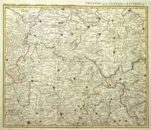
Identifikation (Karte/Plan): Originaldatierung: [Amsterdam, ca. 1662]
Identifikation (Karte/Plan): Originaltitel: FRANCONIA Vulgo FRANKENLANDT
Identifikation (Karte/Plan): Inhaltliche Beschreibung: Areal: Vacha, Eger, Ingolstadt, Frankfurt
Herstellerangaben: Erscheinungsort: Amsterdam
Weitere Angaben (Karte/Plan): Maßstab: [ca. 1:480.000]
Weitere Angaben (Karte/Plan): Ausführung: Papier, kolorierter Kupferstich
Weitere Angaben (Karte/Plan): Blattzahl: 1
Vermerke: Deskriptoren: Deutschland (Süd) / Franken
Vermerke: Deskriptoren: Blaeu, Johann
- Context
-
Alte Karten und Pläne (bis 1918) >> Deutsches Reich (ohne Hessen-Darmstadt) >> Teile des Deutschen Reichs >> Südlich des Mains
- Holding
-
P 1 Alte Karten und Pläne (bis 1918)
- Creator
-
J[ohann] Blaeu excudit
- Date of creation
-
1662
- Other object pages
- Rights
-
Es gelten die Nutzungsbedingungen der Staatsarchive in Hessen.
- Last update
-
01.07.2025, 1:38 PM CEST
Data provider
This object is provided by:
Hessisches Staatsarchiv Darmstadt. If you have any questions about the object, please contact the data provider.
Hessisches Staatsarchiv Darmstadt. If you have any questions about the object, please contact the data provider.
Object type
- Karte/Plan
Associated
- J[ohann] Blaeu excudit
Time of origin
- 1662
Other Objects (12)

Karte von Franken
Karte von Ost-Franken
Karte der Grafschaft Giech in Franken
Karte von Franken mit Marschrouten der preussischen Armee unter Prinz Heinrich von Preußen (Siebenjähriger Krieg)
WHK 21 Österreichischer Sukzessionskrieg 1740-1748 bis zum Aachener Frieden: Karte der Kriegsschauplätze in Bayern und Franken, 1740
Karte von Schlangenbad [Karte fehlt]
. Karte des Gemeindewaldes von Bremthal: Karte
Karte von Hessen ('Neue Hessische Karte')
. Karte der Gemeindewälder von Dillhausen: Karte 3
. Karte der Gemeindewälder von Dillhausen: Karte 1
. Karten des Gemeindewaldes von Bleidenstadt: Karte 2
. Karte des Gemeindewaldes von Manderbach: Karte 1
Karte von Franken
Karte von Ost-Franken
Karte der Grafschaft Giech in Franken
Karte von Franken mit Marschrouten der preussischen Armee unter Prinz Heinrich von Preußen (Siebenjähriger Krieg)
WHK 21 Österreichischer Sukzessionskrieg 1740-1748 bis zum Aachener Frieden: Karte der Kriegsschauplätze in Bayern und Franken, 1740
Karte von Schlangenbad [Karte fehlt]
. Karte des Gemeindewaldes von Bremthal: Karte
Karte von Hessen ('Neue Hessische Karte')
. Karte der Gemeindewälder von Dillhausen: Karte 3
. Karte der Gemeindewälder von Dillhausen: Karte 1
. Karten des Gemeindewaldes von Bleidenstadt: Karte 2