Affordable Sensors for Speditive and Accurate Documentation of Built Heritage: First Tests and Preliminary Results
Abstract. When facing unregulated human interventions, the tumultuous backdrop of wars, and the relentless impact of climate change, a significant effect is held on those structures that stand as custodians of our cultural identity and historical legacy. The need to document their status is an essential first step toward preservation and restoration. This contribution will analyze and compare diverse datasets acquired through three distinct methods: Terrestrial Laser Scanner, Apple’s iPhone 15 Pro with no additional tool, and iPhone 15 Pro using Pix4D viDoc RTK Rover to assess the quality and accuracy of point clouds, as well as to determine the feasibility of each technique for the expeditious documentation of endangered built heritage. The use of mass-distributed low-cost sensors provides a rapid and cost-effective means to capture detailed 3D models of built heritage while, at the same time, democratizing the process of documentation. Low-cost sensors not only facilitate documentation but also enhance the efficiency of conservation efforts. The precision of LiDAR sensors helps identify structural vulnerabilities, allowing conservationists to prioritize interventions and allocate resources wisely. Furthermore, detailed imagery will enable conservationists to monitor subtle structural changes over time, acting as an early warning system against potential threats. As an additional aid, the RTK Rover enables centimeter-level positioning accuracy while maintaining a compact and fast deployable design, and the direct measurement of Ground Control Points (GCPs) significantly streamlines the surveying process and equipment footprint.
- Standort
-
Deutsche Nationalbibliothek Frankfurt am Main
- Umfang
-
Online-Ressource
- Sprache
-
Englisch
- Erschienen in
-
Affordable Sensors for Speditive and Accurate Documentation of Built Heritage: First Tests and Preliminary Results ; volume:XLVIII-1-2024 ; year:2024 ; pages:487-493 ; extent:7
The International Archives of the Photogrammetry, Remote Sensing and Spatial Information Sciences ; XLVIII-1-2024 (2024), 487-493 (gesamt 7)
- Urheber
-
Martino, Alessio
Lingua, Andrea Maria
Maschio, Paolo
- DOI
-
10.5194/isprs-archives-XLVIII-1-2024-487-2024
- URN
-
urn:nbn:de:101:1-2405160448384.869966007713
- Rechteinformation
-
Open Access; Der Zugriff auf das Objekt ist unbeschränkt möglich.
- Letzte Aktualisierung
-
14.08.2025, 10:51 MESZ
Datenpartner
Deutsche Nationalbibliothek. Bei Fragen zum Objekt wenden Sie sich bitte an den Datenpartner.
Beteiligte
- Martino, Alessio
- Lingua, Andrea Maria
- Maschio, Paolo
Ähnliche Objekte (12)

REGULARIZED REBUILD WORKFLOW OF HBIM FOR BUILT HERITAGE DOCUMENTATION
SOFTWARE TOOLS FOR IN-SITU DOCUMENTATION OF BUILT HERITAGE
Built heritage
DOCUMENTATION AND MONITORING OF BUILT HERITAGE IN ABU DHABI, UAE
BUILT HERITAGE DOCUMENTATION AND MANAGEMENT: AN INTEGRATED CONSERVATION APPROACH IN BAGAN
Introduction: tourism and built heritage
Nepal Heritage Documentation Project
INTEGRATED 3D SURVEY FOR THE DOCUMENTATION AND VISUALIZATION OF A ROCK-CUT UNDERGROUND BUILT HERITAGE
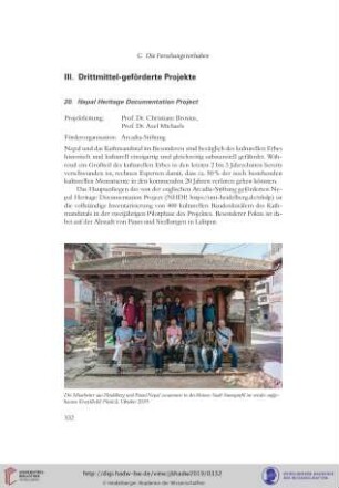
20. Nepal Heritage Documentation Project
Nepal Heritage Documentation Project (NHDP)
18. Nepal Heritage Documentation Project
20. Nepal Heritage Documentation Project
REGULARIZED REBUILD WORKFLOW OF HBIM FOR BUILT HERITAGE DOCUMENTATION
SOFTWARE TOOLS FOR IN-SITU DOCUMENTATION OF BUILT HERITAGE
Built heritage
DOCUMENTATION AND MONITORING OF BUILT HERITAGE IN ABU DHABI, UAE
BUILT HERITAGE DOCUMENTATION AND MANAGEMENT: AN INTEGRATED CONSERVATION APPROACH IN BAGAN
Introduction: tourism and built heritage
Nepal Heritage Documentation Project
INTEGRATED 3D SURVEY FOR THE DOCUMENTATION AND VISUALIZATION OF A ROCK-CUT UNDERGROUND BUILT HERITAGE
20. Nepal Heritage Documentation Project
Nepal Heritage Documentation Project (NHDP)
18. Nepal Heritage Documentation Project