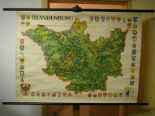
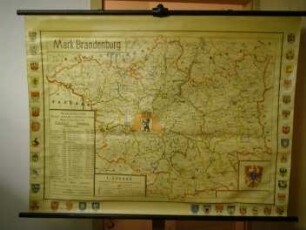
Wandkarte
Geografische Wandkarte von Nordeuropa für den Schulunterricht in der Bundesrepublik in den 1960er Jahren
- Alternative title
-
Ostseeländer
- Location
-
Deutsches Historisches Museum, Berlin
- Inventory number
-
Do2 2013/2140
- Measurements
-
Höhe x Breite: 216 x 198 cm
- Material/Technique
-
Holz, Stahl, Papier : Leinwand, gedruckt
- Classification
-
Kartografie (Gattung)
- Subject (what)
-
Geographie
Schule
Europa
Ostsee
- Event
-
Herstellung
- (who)
-
Druckerei| Verlag: Georg Westermann Verlag
- (where)
-
Braunschweig, Deutschland [historisch: Bundesrepublik Deutschland]
- (when)
-
1964
- Rights
-
Deutsches Historisches Museum
- Last update
-
24.03.2023, 9:27 AM CET
Data provider
This object is provided by:
Stiftung Deutsches Historisches Museum. If you have any questions about the object, please contact the data provider.
Stiftung Deutsches Historisches Museum. If you have any questions about the object, please contact the data provider.
Object type
- Wandkarte
Associated
- Druckerei| Verlag: Georg Westermann Verlag
Time of origin
- 1964
Other Objects (12)

Geografische Wandkarte für den Schulunterricht in der Bundesrepublik in den 1960er Jahren mit den beiden deutschen Staaten und ihren Nachbarländern
Geografische Wandkarte für den Schulunterricht in der Bundesrepublik in den 1960er Jahren mit den beiden deutschen Staaten und ihren Nachbarländern
Geografische Wandkarte von Mitteleuropa für den Schulunterricht in der Bundesrepublik in den 1970er Jahren
Geografische Wandkarte der Bundesrepublik Deutschland für den Schulunterricht in der DDR in den 1980er Jahren
Geografische Wandkarte des Kreises Seelow für den Schulunterricht in der DDR in den 1980er Jahren
Wandkarte
Wandkarte
Wandkarte

Wandkarte zur bibl. Geschichte
Gerollte Wandkarte zur europäischen Landwirtschaft

Schul-Wandkarte der Deutschen Kolonien
Gerollte Wandkarte zur administrativen Gliederung der DDR
Geografische Wandkarte für den Schulunterricht in der Bundesrepublik in den 1960er Jahren mit den beiden deutschen Staaten und ihren Nachbarländern
Geografische Wandkarte für den Schulunterricht in der Bundesrepublik in den 1960er Jahren mit den beiden deutschen Staaten und ihren Nachbarländern
Geografische Wandkarte von Mitteleuropa für den Schulunterricht in der Bundesrepublik in den 1970er Jahren
Geografische Wandkarte der Bundesrepublik Deutschland für den Schulunterricht in der DDR in den 1980er Jahren
Geografische Wandkarte des Kreises Seelow für den Schulunterricht in der DDR in den 1980er Jahren
Wandkarte
Wandkarte
Wandkarte
Wandkarte zur bibl. Geschichte
Gerollte Wandkarte zur europäischen Landwirtschaft
Schul-Wandkarte der Deutschen Kolonien