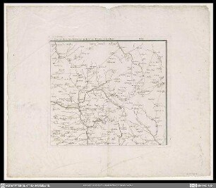
Grafik | Landkarte
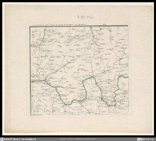
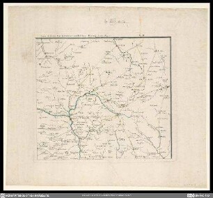
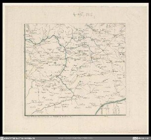
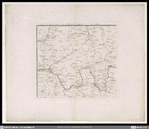
Franconiae postarum tabulam hanc geographicam sacram esse,
Historische Teilkarte von Franken von Nürnberg bis Augsburg bzw. Donauwörth bis Regensburg mit Titelkartusche unten rechts von Wappen gekrönt
- Alternative title
-
Cours de postes dans la Franconie, celui de Nurnberg, celui de Ratisbone & d'Augspourg
- Collection
-
Pictothek
- Identifier
-
36/A 1.45-4
- Source
-
Universitätsbibliothek Würzburg
- Extent
-
345 mm x 380 mm
- Language
-
Latein
Französisch
- Subject
-
Altkarte
- Subject (where)
-
Franken
- URN
-
urn:nbn:de:bvb:20-36a1454term73899081-0
- Last update
-
06.03.2025, 3:26 PM CET
Data provider
This object is provided by:
Universitätsbibliothek Würzburg. If you have any questions about the object, please contact the data provider.
Universitätsbibliothek Würzburg. If you have any questions about the object, please contact the data provider.
Object type
- Grafik
- Landkarte
Associated
Time of origin
- 1759
Other Objects (12)
Franconiae postarum tabulam hanc geographicam sacram esse,
Franconiae postarum tabulam hanc geographicam sacram esse,
Franconiae postarum tabulam hanc geographicam sacram esse,

Franconiae postarum tabulam hanc geographicam sacram esse: cupiunt Honeanniani
Franconiae postarum tabulam hanc geographicam sacram esse: cupiunt Honeanniani
Franconiae postarum tabulam hanc geographicam sacram esse: cupiunt Honeanniani
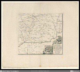
Franconiae postarum tabulam hanc geographicam sacram esse: cupiunt Honeanniani

Franconiae Postarum; Postrouten in Franken, 1759
![Tabulam hanc Aegypti [...]](https://iiif.deutsche-digitale-bibliothek.de/image/2/2375fb47-4795-4304-ae82-4cc2e838e0d7/full/!306,450/0/default.jpg)
Tabulam hanc Aegypti [...]
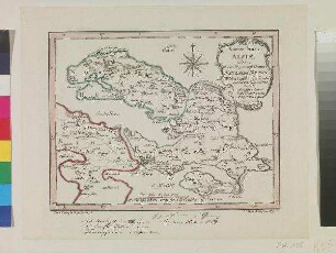
Novam hanc Alsiæ tabulam

Thuringiae Orientalis Tabulam hanc Geographicam
![Lectori Benevolo Tabulam Hanc Regni Congo [...]](https://iiif.deutsche-digitale-bibliothek.de/image/2/404c6eac-722f-444f-8dbb-0e37fdd3eda9/full/!306,450/0/default.jpg)
Lectori Benevolo Tabulam Hanc Regni Congo [...]
Franconiae postarum tabulam hanc geographicam sacram esse,
Franconiae postarum tabulam hanc geographicam sacram esse,
Franconiae postarum tabulam hanc geographicam sacram esse,
Franconiae postarum tabulam hanc geographicam sacram esse: cupiunt Honeanniani
Franconiae postarum tabulam hanc geographicam sacram esse: cupiunt Honeanniani
Franconiae postarum tabulam hanc geographicam sacram esse: cupiunt Honeanniani
Franconiae postarum tabulam hanc geographicam sacram esse: cupiunt Honeanniani
Franconiae Postarum; Postrouten in Franken, 1759
Tabulam hanc Aegypti [...]
Novam hanc Alsiæ tabulam
Thuringiae Orientalis Tabulam hanc Geographicam