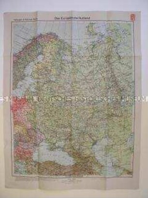
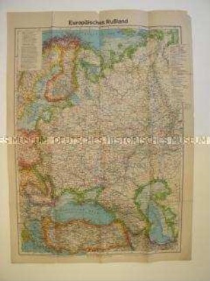
Politisch-geografische Karte
Politisch-geografische Karte aus dem 2. Weltkrieg vom europäischen Teil der UdSSR
- Alternative title
-
Europäisches Rußland
- Location
-
Deutsches Historisches Museum, Berlin
- Inventory number
-
Do2 2001/111
- Measurements
-
Höhe x Breite: 110 x 85 cm (aufgeschlagen), Höhe x Breite: 27,5 x 21,5 cm (gefaltet)
- Material/Technique
-
Papier, gedruckt
- Classification
-
Kartografie (Gattung)
- Subject (what)
-
Geographie
- Event
-
Herstellung
- (who)
-
Verlag: Gea Verlag Albers KG
- (where)
-
Berlin, Deutschland [historisch: Deutsches Reich]
- (when)
-
um 1940
- Rights
-
Deutsches Historisches Museum
- Last update
-
24.03.2023, 9:30 AM CET
Data provider
This object is provided by:
Stiftung Deutsches Historisches Museum. If you have any questions about the object, please contact the data provider.
Stiftung Deutsches Historisches Museum. If you have any questions about the object, please contact the data provider.
Object type
- Politisch-geografische Karte
Associated
- Verlag: Gea Verlag Albers KG
Time of origin
- um 1940
Other Objects (12)
Geografische Karte des europäischen Teils der UdSSR

Geografische Karte der Gegend um Rositten in der UdSSR
Geografische Karte der Gegend um Pskow in der UdSSR
Politisch-geografische Karte vom europäischen Teil der UdSSR (Tornisterschrift der Wehrmacht)
UdSSR: Beziehungen zur UdSSR
Politisch-geografische Karte des nordöstlichen Teils der UdSSR (Litauen) nach dem Überfall Deutschlands

UdSSR, Gedenkmedaille 60 Jahre UdSSR
UdSSR, Gemeinschaftsunternehmen in der UdSSR
UdSSR: Verkehr mit der UdSSR
UdSSR, Gemeinschaftsunternehmen in der UdSSR
UdSSR
UdSSR
Geografische Karte des europäischen Teils der UdSSR
Geografische Karte der Gegend um Rositten in der UdSSR
Geografische Karte der Gegend um Pskow in der UdSSR
Politisch-geografische Karte vom europäischen Teil der UdSSR (Tornisterschrift der Wehrmacht)
UdSSR: Beziehungen zur UdSSR
Politisch-geografische Karte des nordöstlichen Teils der UdSSR (Litauen) nach dem Überfall Deutschlands
UdSSR, Gedenkmedaille 60 Jahre UdSSR
UdSSR, Gemeinschaftsunternehmen in der UdSSR
UdSSR: Verkehr mit der UdSSR
UdSSR, Gemeinschaftsunternehmen in der UdSSR
UdSSR