Altkarte
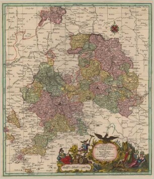
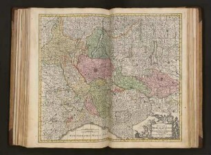
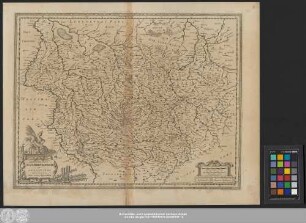
Tabulae Geographicae, Principatus Brandenburg. Culmb. sive Baruthini Pars Inferior : cum adjacentibus Regionibus ; Cum Gratia et Privil. Serenißimi Principis Marggravii Brandenburg-Culmbacensis
- Alternative title
-
Tabulae Geographicae, Principatus Brandenburgico-Culmbacensis sive Baruthini Pars Inferior
- Location
-
München, Bayerische Staatsbibliothek -- Mapp. XI,331 dc
- Dimensions
-
55 x 47 cm
- Extent
-
1 Kt.
- Language
-
Latein
- Notes
-
Kupferstich
Maßstab in graph. Form (Teutsche Meile). - Titelkartusche oben links
- Keyword
-
Amtsbezirk
Fürstentum Bayreuth
Fürstentum Bayreuth
- Event
-
Veröffentlichung
- (where)
-
Aug. Vindel.//Augsburg//
- (who)
-
Seutter
- (when)
-
s.a. [zwischen 1740 u. 1756]
- Contributor
- URN
-
urn:nbn:de:bvb:12-bsb00037957-1
- Last update
-
16.04.2025, 8:44 AM CEST
Data provider
This object is provided by:
Bayerische Staatsbibliothek. If you have any questions about the object, please contact the data provider.
Bayerische Staatsbibliothek. If you have any questions about the object, please contact the data provider.
Object type
- Altkarte
Associated
- Seutter, Matthäus
- Seutter
Time of origin
- s.a. [zwischen 1740 u. 1756]
Other Objects (12)

Tabulae geographicae principatus Brandenburg-Culmbach sive Baruthini pars inferior cum adjacentibus regionibus
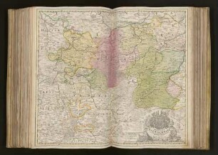
Tabula Principatus Brandenburgico-Culmbacensis sive Baruthini Pars Superior : cum adjacentibus Regionibus ; Cum Gratia et Priv. Serenissimi Principis Marggravii Brandenburg-Culmbacensis
Comitatus Wertheim cum adjacentibus
Hungaria cum adjacentibus Provinciis.
Brabantiae Ducatus cum adjacentibus provinciis
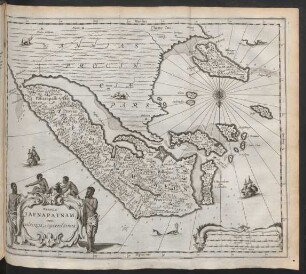
Regnum Jafnapatam; cum Insusis Adjacentibus
COMITATVS WERTHEIM cum adjacentibus (Kupferstich )
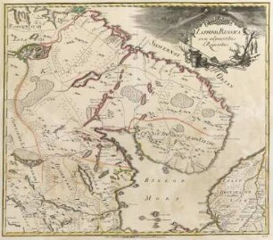
No. 1. Lapponi Russica cum adjacentibus Regionibus
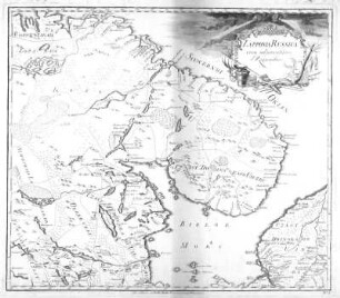
No. 1. Lapponi Russica cum adjacentibus Regionibus
Ducatus Mediolanensis cum adjacentibus Principat. Et Dominiis
Archiepiscopatvs Maghdebvrgensis Et Anhaltinvs Dvcatvs : Cum terris adjacentibus
Principatus Isenacensis cum adjacentibus vicinorum Statuum Ditionibus exhibitus
Tabulae geographicae principatus Brandenburg-Culmbach sive Baruthini pars inferior cum adjacentibus regionibus
Tabula Principatus Brandenburgico-Culmbacensis sive Baruthini Pars Superior : cum adjacentibus Regionibus ; Cum Gratia et Priv. Serenissimi Principis Marggravii Brandenburg-Culmbacensis
Comitatus Wertheim cum adjacentibus
Hungaria cum adjacentibus Provinciis.
Brabantiae Ducatus cum adjacentibus provinciis
Regnum Jafnapatam; cum Insusis Adjacentibus
COMITATVS WERTHEIM cum adjacentibus (Kupferstich )
No. 1. Lapponi Russica cum adjacentibus Regionibus
No. 1. Lapponi Russica cum adjacentibus Regionibus
Ducatus Mediolanensis cum adjacentibus Principat. Et Dominiis
Archiepiscopatvs Maghdebvrgensis Et Anhaltinvs Dvcatvs : Cum terris adjacentibus