Karte / Plan
Carte militaire des environs de Paris
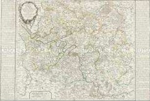
Ausführlicher Titel: "Carte militaire des environs de Paris relative aux travaux de défens éxécutés ou projetés en 1815 "
- topografische Karten von Paris
- links Titel
- oben Griechenland
- unten Kroatien und Adria
- Archivaliensignatur
-
Abt. Hauptstaatsarchiv Stuttgart, N 100 Nr. 410
- Maße
-
64 x 86 (Höhe x Breite)
- Sonstige Erschließungsangaben
-
Geografische Begrenzung: li. o. Argenteuil; re. o. Aunay li. u. Meudon; re. u. Ormesson
Ausführung: einfarbig
Entstehungsstufe: Ausdruck oder Fertigdruck
Herausgeber: Institut geographique national
Herstellungsort: Paris
Orientierung: N
Originalmaßstab: 4000 Meter = 13,4 cm
Maßstab: ca 1 : 30.000
Blattzahl: 1
- Kontext
-
Ältere gedruckte Karten >> Frankreich
- Bestand
-
Landesarchiv Baden-Württemberg, Abt. Hauptstaatsarchiv Stuttgart, N 100 Ältere gedruckte Karten
- Indexbegriff Ort
-
Ormesson, bei Paris
Paris [F]
- Urheber
-
Autor/Fotograf: E. Collin
- Laufzeit
-
1815
- Weitere Objektseiten
- Digitalisat im Angebot des Archivs
- Rechteinformation
-
Es gelten die Nutzungsbedingungen des Landesarchivs Baden-Württemberg.
- Letzte Aktualisierung
-
21.11.2025, 15:28 MEZ
Datenpartner
Dieses Objekt wird bereitgestellt von:
Landesarchiv Baden-Württemberg. Bei Fragen zum Objekt wenden Sie sich bitte an den Datenpartner.
Landesarchiv Baden-Württemberg. Bei Fragen zum Objekt wenden Sie sich bitte an den Datenpartner.
Objekttyp
- Karten und Pläne
Beteiligte
- Autor/Fotograf: E. Collin
Entstanden
- 1815
Ähnliche Objekte (12)
Carte des Environs de Paris

Environs de Paris levés géométriquement

Environs de Paris levés géométriquement

Environs de Paris levés géométriquement

Croquis de Carte militaire de la Forêt Noire

Carte Chorographique et Militaire du Duché de Mecklenburg-Strehlitz
![Environs de Paris [zu Nr. 48]](/assets/placeholder/searchResultMediaNoDigitisedMedia.png)
Environs de Paris [zu Nr. 48]

Croquis de Carte militaire de la partie Méridionalede la Forêt Noire
Kolorierte "Carte de l'Isle de Schalampe (im Rhein) et de ses environs"

Nouvelle Carte du Département de Paris

Carte topographique des environs de Paris en 4 feuilles. - Paris, 1813

Paris (Frankreich) Wegekarte von Paris und Umgebung Nouvelle Carte routière des environs de Paris 1835 2 Meilen = 3,5 cm 29,5 x 37,5 Druck: Charles Simenneau Landsberg-Velen Nr. 710
Carte des Environs de Paris
Environs de Paris levés géométriquement
Environs de Paris levés géométriquement
Environs de Paris levés géométriquement
Croquis de Carte militaire de la Forêt Noire
Carte Chorographique et Militaire du Duché de Mecklenburg-Strehlitz
Environs de Paris [zu Nr. 48]
Croquis de Carte militaire de la partie Méridionalede la Forêt Noire
Kolorierte "Carte de l'Isle de Schalampe (im Rhein) et de ses environs"
Nouvelle Carte du Département de Paris
Carte topographique des environs de Paris en 4 feuilles. - Paris, 1813