- Alternative title
-
Mitteleuropa
- Location
-
Deutsches Historisches Museum, Berlin
- Inventory number
-
DG 90/1262
- Measurements
-
Höhe x Breite: 206 x 204 cm
- Material/Technique
-
Papier : Leinwand, Holz, gedruckt
- Classification
-
Karten, Pläne, Risse (Gattung)
- Subject (what)
-
Schule
Geographie
- Event
-
Herstellung
- (who)
-
Entwerfer: Hermann Haack
Herausgeber und Produzent: VEB Geographisch-Karthographische Anstalt
- (where)
-
Gotha, Deutschland [historisch: Deutsche Demokratische Republik]
- (when)
-
um 1970
- Rights
-
Deutsches Historisches Museum
- Last update
-
24.03.2023, 9:27 AM CET
Data provider
This object is provided by:
Stiftung Deutsches Historisches Museum. If you have any questions about the object, please contact the data provider.
Stiftung Deutsches Historisches Museum. If you have any questions about the object, please contact the data provider.
Object type
- Geographische Karte
Associated
- Entwerfer: Hermann Haack
- Herausgeber und Produzent: VEB Geographisch-Karthographische Anstalt
Time of origin
- um 1970
Other Objects (12)

Geografische Schulwandkarte von Europa und Nordafrika
Gerollte Schulwandkarte zur Geografie Osteuropas
Schulwandkarte von Mittel- und Südamerika
Schulwandkarte von Mittel- und Südamerika
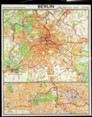
Schulwandkarte von Berlin
Schulwandkarte von Asien

Schulwandkarte von Palästina
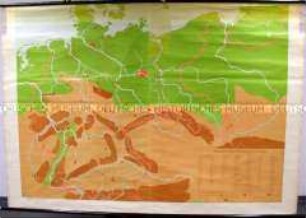
Schulwandkarte von Deutschland
Schulwandkarte von Nordamerika
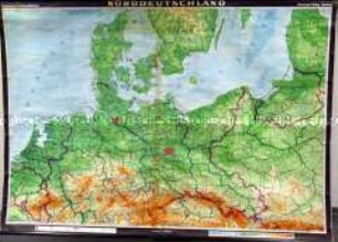
Schulwandkarte von Norddeutschland
Schulwandkarte von Nordamerika
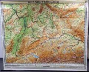
Schulwandkarte von Süddeutschland
Geografische Schulwandkarte von Europa und Nordafrika
Gerollte Schulwandkarte zur Geografie Osteuropas
Schulwandkarte von Mittel- und Südamerika
Schulwandkarte von Mittel- und Südamerika
Schulwandkarte von Berlin
Schulwandkarte von Asien
Schulwandkarte von Palästina
Schulwandkarte von Deutschland
Schulwandkarte von Nordamerika
Schulwandkarte von Norddeutschland
Schulwandkarte von Nordamerika