- Alternativer Titel
-
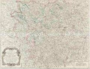
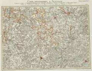
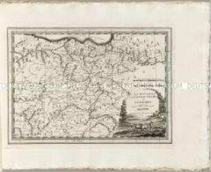
LA LORRAINE / qui comprend / LES DUCHÉS DE LORRAINE et DE BAR / ET LES BALLIAGES DES EVESCHÉS ET DES VILLES
- Standort
-
Deutsches Historisches Museum, Berlin
- Inventarnummer
-
Do 2006/1190
- Maße
-
Höhe x Breite: 61 x 97 cm (Blatt)
Höhe x Breite: 52 x 85 cm (Karte)
Höhe x Breite: 57 x 88,3 cm (Platte)
- Material/Technik
-
Papier, Kupferstich
- Klassifikation
-
Kartografie (Gattung)
- Bezug (was)
-
Lothringen
Frankreich
- Ereignis
-
Herstellung
- (wer)
-
Kartograf, Geograph: Guillaume Sanson
Geograph, Kartograf, Verleger: Alexis-Hubert Jaillot
- (wo)
-
Paris, Frankreich
- (wann)
-
1674
- Rechteinformation
-
Deutsches Historisches Museum
- Letzte Aktualisierung
-
24.03.2023, 09:30 MEZ
Datenpartner
Dieses Objekt wird bereitgestellt von:
Stiftung Deutsches Historisches Museum. Bei Fragen zum Objekt wenden Sie sich bitte an den Datenpartner.
Stiftung Deutsches Historisches Museum. Bei Fragen zum Objekt wenden Sie sich bitte an den Datenpartner.
Objekttyp
- Regionalkarte
Beteiligte
- Kartograf, Geograph: Guillaume Sanson
- Geograph, Kartograf, Verleger: Alexis-Hubert Jaillot
Entstanden
- 1674
Ähnliche Objekte (12)
Carte des Duchés de Lorraine et Bar
Grand Atlas . Bl. 56 (Lothringen, Bar, Champagne): Contenante une Partie des Etats de Lorraine, du Duché de Barrois et de Champagne etc
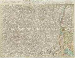
Grand Atlas . Bl. 57 (Elsass, Lothringen, Salm): Contenant le Margraviat de l'Alsace, une Partie du Duché de Lorraine, et le Principauté de Salm.
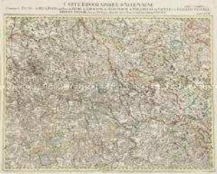
Grand Atlas . Bl. 47 (Luxemburg, Lothringen, Bar, Champgne...): Contenante une Partie des Duchès de Luxembourg, de Lorraine et de Bar; de la Province de Champagne, des Evêchès de Metz et de Verdun, etc. etc.
Grand Atlas . Bl. 65 (Champagne, Burgund, Bar,Lothringen): Contenante une Partie de Champagne, Bourgogne, du Duché de Barrois, des Etats de Lorraine et de Franche Comté et.
Grand Atlas . Bl. 66 (Lothringen, Elsass, Baden, Schweiz...): Contenant une Partie du Duché de Lorraine, d'Allsas, et du Margraviat Superieur de Baaden Durlach, L'Evecé de Basel, une Partie de la Suisse savoir les Cantons de Basel, et Solothurn, le Territoire de Biel, une Partie de la Franche Comté, et de la Bourgogne.
Grand Atlas . Bl. 48 (Frankreich, Pfalz, Falkenstein, Leiningen, Bitsch): Contenant le Duché de Deux Ponts, une Partie du Duché de Lorraine, de l'Electorat de Palatinat, les Comtés de Falckenstein, Leiningen, Bitsche et et (Verbessertes Blatt)
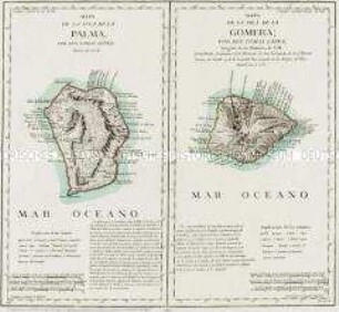
Mapa de la Isla de la Palma / Mapa de la Isla de la Gomera
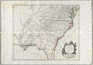
Partie Méridionale de la Louisiane, avec de la Floride, la Caroline et la Virginie
Nuovo Atlante Geografico Universale: La Biscaglia La Castilia Vecchia e La Navarra

La Prusse
La Prusse
Carte des Duchés de Lorraine et Bar
Grand Atlas . Bl. 56 (Lothringen, Bar, Champagne): Contenante une Partie des Etats de Lorraine, du Duché de Barrois et de Champagne etc
Grand Atlas . Bl. 57 (Elsass, Lothringen, Salm): Contenant le Margraviat de l'Alsace, une Partie du Duché de Lorraine, et le Principauté de Salm.
Grand Atlas . Bl. 47 (Luxemburg, Lothringen, Bar, Champgne...): Contenante une Partie des Duchès de Luxembourg, de Lorraine et de Bar; de la Province de Champagne, des Evêchès de Metz et de Verdun, etc. etc.
Grand Atlas . Bl. 65 (Champagne, Burgund, Bar,Lothringen): Contenante une Partie de Champagne, Bourgogne, du Duché de Barrois, des Etats de Lorraine et de Franche Comté et.
Grand Atlas . Bl. 66 (Lothringen, Elsass, Baden, Schweiz...): Contenant une Partie du Duché de Lorraine, d'Allsas, et du Margraviat Superieur de Baaden Durlach, L'Evecé de Basel, une Partie de la Suisse savoir les Cantons de Basel, et Solothurn, le Territoire de Biel, une Partie de la Franche Comté, et de la Bourgogne.
Grand Atlas . Bl. 48 (Frankreich, Pfalz, Falkenstein, Leiningen, Bitsch): Contenant le Duché de Deux Ponts, une Partie du Duché de Lorraine, de l'Electorat de Palatinat, les Comtés de Falckenstein, Leiningen, Bitsche et et (Verbessertes Blatt)
Mapa de la Isla de la Palma / Mapa de la Isla de la Gomera
Partie Méridionale de la Louisiane, avec de la Floride, la Caroline et la Virginie
Nuovo Atlante Geografico Universale: La Biscaglia La Castilia Vecchia e La Navarra
La Prusse
La Prusse
Carte des Duchés de Lorraine et Bar
Grand Atlas . Bl. 56 (Lothringen, Bar, Champagne): Contenante une Partie des Etats de Lorraine, du Duché de Barrois et de Champagne etc
Grand Atlas . Bl. 57 (Elsass, Lothringen, Salm): Contenant le Margraviat de l'Alsace, une Partie du Duché de Lorraine, et le Principauté de Salm.
Grand Atlas . Bl. 47 (Luxemburg, Lothringen, Bar, Champgne...): Contenante une Partie des Duchès de Luxembourg, de Lorraine et de Bar; de la Province de Champagne, des Evêchès de Metz et de Verdun, etc. etc.
Grand Atlas . Bl. 65 (Champagne, Burgund, Bar,Lothringen): Contenante une Partie de Champagne, Bourgogne, du Duché de Barrois, des Etats de Lorraine et de Franche Comté et.
Grand Atlas . Bl. 66 (Lothringen, Elsass, Baden, Schweiz...): Contenant une Partie du Duché de Lorraine, d'Allsas, et du Margraviat Superieur de Baaden Durlach, L'Evecé de Basel, une Partie de la Suisse savoir les Cantons de Basel, et Solothurn, le Territoire de Biel, une Partie de la Franche Comté, et de la Bourgogne.
Grand Atlas . Bl. 48 (Frankreich, Pfalz, Falkenstein, Leiningen, Bitsch): Contenant le Duché de Deux Ponts, une Partie du Duché de Lorraine, de l'Electorat de Palatinat, les Comtés de Falckenstein, Leiningen, Bitsche et et (Verbessertes Blatt)
Mapa de la Isla de la Palma / Mapa de la Isla de la Gomera
Partie Méridionale de la Louisiane, avec de la Floride, la Caroline et la Virginie
Nuovo Atlante Geografico Universale: La Biscaglia La Castilia Vecchia e La Navarra
La Prusse