Regionalkarte
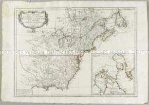
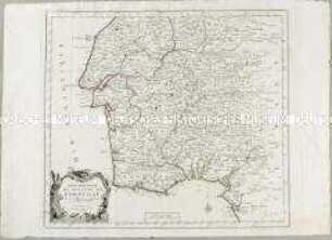
Partie Méridionale de la Louisiane, avec de la Floride, la Caroline et la Virginie
- Alternativer Titel
-
PARTIE MÉRIDIONALE / de la / LOUISIANE, / avec la
- Standort
-
Deutsches Historisches Museum, Berlin
- Inventarnummer
-
Do 2006/906
- Maße
-
Höhe x Breite: 55 x 79 cm (Blatt)
Höhe x Breite: 46 x 55,5 cm (Karte)
Höhe x Breite: 49 x 58,5 cm (Platte)
- Material/Technik
-
Papier, Kupferstich, grenzkoloriert
- Klassifikation
-
Kartografie (Gattung)
- Bezug (was)
-
Nordamerika
- Ereignis
-
Herstellung
- (wer)
-
Geograph, Kartograf: Jean Baptiste Bourguignon d' Anville
Stecher, Kartograf: Paolo Santini
Kartograf, Verleger: Giuseppe Antonio Remondini
- (wo)
-
Venedig, Italien
- (wann)
-
um 1776
- Rechteinformation
-
Deutsches Historisches Museum
- Letzte Aktualisierung
-
24.03.2023, 09:27 MEZ
Datenpartner
Dieses Objekt wird bereitgestellt von:
Stiftung Deutsches Historisches Museum. Bei Fragen zum Objekt wenden Sie sich bitte an den Datenpartner.
Stiftung Deutsches Historisches Museum. Bei Fragen zum Objekt wenden Sie sich bitte an den Datenpartner.
Objekttyp
- Regionalkarte
Beteiligte
- Geograph, Kartograf: Jean Baptiste Bourguignon d' Anville
- Stecher, Kartograf: Paolo Santini
- Kartograf, Verleger: Giuseppe Antonio Remondini
Entstanden
- um 1776
Ähnliche Objekte (12)
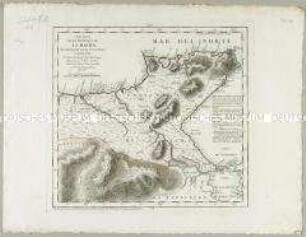
Carte Générale du Canada, de la Louisiane, de la Floride, de la Caroline, de la Virginie, de la Nouvelle Angleterre etc. Mit einer Anschlusskarte
Carte de la Champagne. Nebentitel: Partie Méridionale de Champagne
Nuovo Atlante Geografico Universale: La Parte Meridionale del Regno di Portogallo
Mapa de la Isla de la Palma / Mapa de la Isla de la Gomera
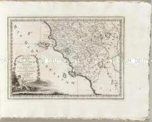
Nuovo Atlante Geografico Universale: La Parte Meridionale Del Gran-Ducato Di Toscana
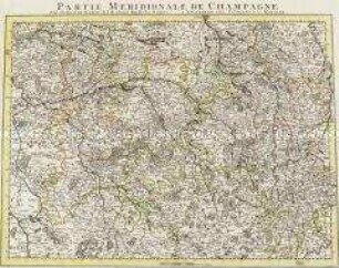
Partie Meridionale de Champagne
Carta Plana de la Provincia de La Hacha
Partie Méridionale du Royaume de Portugal
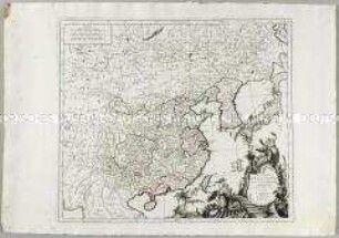
L'Empire de la Chine avec la Tartarie Chinoise

La Comtè de Glatz
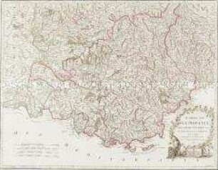
Carte de la Provence
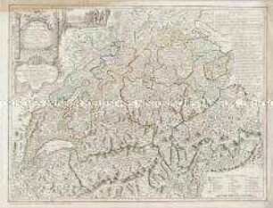
Carte de la Suisse
Carte Générale du Canada, de la Louisiane, de la Floride, de la Caroline, de la Virginie, de la Nouvelle Angleterre etc. Mit einer Anschlusskarte
Carte de la Champagne. Nebentitel: Partie Méridionale de Champagne
Nuovo Atlante Geografico Universale: La Parte Meridionale del Regno di Portogallo
Mapa de la Isla de la Palma / Mapa de la Isla de la Gomera
Nuovo Atlante Geografico Universale: La Parte Meridionale Del Gran-Ducato Di Toscana
Partie Meridionale de Champagne
Carta Plana de la Provincia de La Hacha
Partie Méridionale du Royaume de Portugal
L'Empire de la Chine avec la Tartarie Chinoise
La Comtè de Glatz
Carte de la Provence