Luftbildpläne
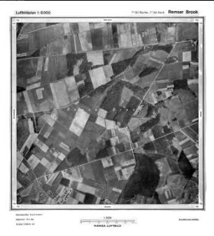
Remser Brook, Gauß-Krüger-Koordinaten: Rechtswert: 3450, Hochwert: 5758
- title of record
-
Marienfeld-Remse - Süd, Gauß-Krüger-Koordinaten: Rechtswert: 3448, Hochwert: 5756
- Dimensions
-
Maßstab: 1:10.000
- Further information
-
Land: NRW
- Context
-
Hansa Luftbild: Luftbildpläne 1:10.000 >> 5. Rechtswerte beginnend mit 34 >> Marienfeld-Remse - Süd, Gauß-Krüger-Koordinaten: Rechtswert: 3448, Hochwert: 5756
- Holding
-
RW 0434 Hansa Luftbild: Luftbildpläne 1:10.000
- Provenance
-
Hansa Luftbild
- Date of creation
-
April 1964
- Other object pages
- Delivered via
- Last update
-
24.06.2025, 2:09 PM CEST
Data provider
This object is provided by:
Landesarchiv Nordrhein-Westfalen. Abteilung Rheinland. If you have any questions about the object, please contact the data provider.
Landesarchiv Nordrhein-Westfalen. Abteilung Rheinland. If you have any questions about the object, please contact the data provider.
Object type
- Luftbildpläne
Associated
- Hansa Luftbild
Time of origin
- April 1964
Other Objects (12)

Remser Brook, Gauß-Krüger-Koordinaten: Rechtswert: 3450, Hochwert: 5758
Remser Brook, Gauß-Krüger-Koordinaten: Rechtswert: 3450, Hochwert: 5758
Brouillonkarte zur Generalvermessung (R 33) des Remser Bruchs [Remser Brook] und Asselmanns Heide bei Marienfeld, Blatt 3
Remser
Remser Stiftungen
Remser Papiere
Remser Jagdrevier
Einzelne Remser Sachen
Verschiedene Remser Sachen
Remser Fronrenten Register
Ältere Remser Forstsachen
Flurenkarte vom Remser-Revier
Remser Brook, Gauß-Krüger-Koordinaten: Rechtswert: 3450, Hochwert: 5758
Remser Brook, Gauß-Krüger-Koordinaten: Rechtswert: 3450, Hochwert: 5758
Brouillonkarte zur Generalvermessung (R 33) des Remser Bruchs [Remser Brook] und Asselmanns Heide bei Marienfeld, Blatt 3
Remser
Remser Stiftungen
Remser Papiere
Remser Jagdrevier
Einzelne Remser Sachen
Verschiedene Remser Sachen
Remser Fronrenten Register
Ältere Remser Forstsachen