- Location
-
München, Bayerische Staatsbibliothek -- Mapp. VIII,46
- Dimensions
-
51 x 56 cm
- Extent
-
1 Kt.
- Language
-
Deutsch
- Notes
-
Lithographie
Mit 1 Nebenkt.: Route von Verdun und Bar le Duc nach Paris. - Maßstab in graph. Form (Geographische Meilen, Französische Meilen)
- Keyword
-
Eisenbahnnetz
Verkehrsnetz
Karte
Deutschland
Mitteleuropa
- Event
-
Veröffentlichung
- (where)
-
Nürnberg
- (who)
-
Beyerlein
- (when)
-
1852
- Contributor
- URN
-
urn:nbn:de:bvb:12-bsb00019305-4
- Last update
-
27.11.2025, 8:48 AM CET
Data provider
This object is provided by:
Bayerische Staatsbibliothek. If you have any questions about the object, please contact the data provider.
Bayerische Staatsbibliothek. If you have any questions about the object, please contact the data provider.
Object type
- kartografisches Bild
Associated
- Paur, J. (Sonstige)
- Hussendörfer, M. (Sonstige)
- Beyerlein
Time of origin
- 1852
Other Objects (12)

Post und Reise-Charte von Deutschland und den benachbarten Laendern
![Reise Charte durch Pensylvanien [...]](https://iiif.deutsche-digitale-bibliothek.de/image/2/c2b58372-f596-4e8e-9468-660e2244ca24/full/!306,450/0/default.jpg)
Reise Charte durch Pensylvanien [...]
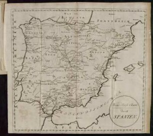
Neue Reise Charte durch Spanien.
Reise Charte durch das Churfürstenthum Brandenburg
Reise Charte durch das Churfürstenthum Brandenburg
Reise Charte von Berlin nach Schwedt

Charte der Regenhöhen von Deutschland
![[Charte]](https://iiif.deutsche-digitale-bibliothek.de/image/2/8751e2e5-0f76-4f26-bc88-d03c6aecbca4/full/!306,450/0/default.jpg)
[Charte]

Karte 29: Reise Charte von Leipzig nach St. Petersburg

Post-Charte des Königreichs Sachsen und der Angränzenden Länder

Post Charte vom Königreich Böhmen verlegt im Jahr 1802

Karte 28: Reise Charte von Leipzig über Prag nach Wien
Post und Reise-Charte von Deutschland und den benachbarten Laendern
Reise Charte durch Pensylvanien [...]
Neue Reise Charte durch Spanien.
Reise Charte durch das Churfürstenthum Brandenburg
Reise Charte durch das Churfürstenthum Brandenburg
Reise Charte von Berlin nach Schwedt
Charte der Regenhöhen von Deutschland
[Charte]
Karte 29: Reise Charte von Leipzig nach St. Petersburg
Post-Charte des Königreichs Sachsen und der Angränzenden Länder
Post Charte vom Königreich Böhmen verlegt im Jahr 1802