- Weitere Titel
-
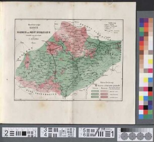
Industrie-Karte von Mähren und Oesterreichisch-Schlesien
- Standort
-
München, Bayerische Staatsbibliothek -- Hbks/X 5 q-1#Karte3
- Maße
-
20 x 15 cm, gefaltet
- Umfang
-
1 Kt.
- Sprache
-
Deutsch
- Anmerkungen
-
mehrfarb. Lithographie
- Erschienen in
-
Die Markgrafschaft Mähren und das Herzogthum Schlesien in ihren geographischen Verhältnissen / unter Mitwirkung mehrerer vaterländischer Naturforscher und Geographen dargestellt von Carl Kořistka ; [Kartenbeilage 3]
- Schlagwort
-
Standort
Industrie
Österreichisch-Schlesien
Mähren
- Ereignis
-
Veröffentlichung
- (wo)
-
Wien
- (wer)
-
Hölzel
- (wann)
-
[1860]
- Beteiligte Personen und Organisationen
- URN
-
urn:nbn:de:bvb:12-bsb00030190-7
- Letzte Aktualisierung
-
16.04.2025, 08:33 MESZ
Datenpartner
Dieses Objekt wird bereitgestellt von:
Bayerische Staatsbibliothek. Bei Fragen zum Objekt wenden Sie sich bitte an den Datenpartner.
Bayerische Staatsbibliothek. Bei Fragen zum Objekt wenden Sie sich bitte an den Datenpartner.
Objekttyp
- Karte
Beteiligte
- Kořistka, Carl
- Köke, Friedrich
- Hölzel
Entstanden
- [1860]
Ähnliche Objekte (12)
Bevölkerungs-Karte von Mähren und Oest. Schlesien

Die Markgrafschaft Mähren und das Herzogtum Schlesien in ihren geogr. Verhältnissen unter Mitw. ...
Adress-Buch der königl. Hauptstadt Olmütz und ihrer Vororte
Raum, Gesellschaft, Wirtschaft, Teil 2 = Jg. 2 HTL
Erdkunde für die Mittelschule in Südtirol, 3, [Hauptbd.]
Hand-Ausgabe von Hölzel's Wandbildern für den Anschauungs- und Sprachunterricht
Erdkunde für die Mittelschule in Südtirol, 1, [Hauptbd.]
Palaeontologie der Umgebung des Balatonsees, Bd. 2

Mitteilungen der Geographischen Gesellschaft Wien. 27 = N.F., Bd. 17. 1884
Palaeontologie der Umgebung des Balatonsees, Bd. 4
Raum, Gesellschaft, Wirtschaft, Teil 1 = Jg. 1 HTL
Mitteilungen der Geographischen Gesellschaft Wien. 1. 1857
Bevölkerungs-Karte von Mähren und Oest. Schlesien
Die Markgrafschaft Mähren und das Herzogtum Schlesien in ihren geogr. Verhältnissen unter Mitw. ...
Adress-Buch der königl. Hauptstadt Olmütz und ihrer Vororte
Raum, Gesellschaft, Wirtschaft, Teil 2 = Jg. 2 HTL
Erdkunde für die Mittelschule in Südtirol, 3, [Hauptbd.]
Hand-Ausgabe von Hölzel's Wandbildern für den Anschauungs- und Sprachunterricht
Erdkunde für die Mittelschule in Südtirol, 1, [Hauptbd.]
Palaeontologie der Umgebung des Balatonsees, Bd. 2
Mitteilungen der Geographischen Gesellschaft Wien. 27 = N.F., Bd. 17. 1884
Palaeontologie der Umgebung des Balatonsees, Bd. 4
Raum, Gesellschaft, Wirtschaft, Teil 1 = Jg. 1 HTL