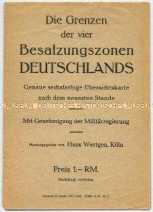
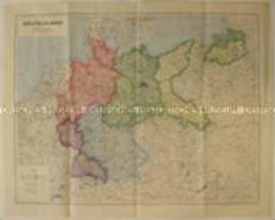
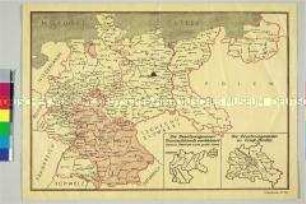
Politisch-administrative Karte
Politisch-administrative Karte von Deutschland und Österreich mit den Besatzungszonen nach dem II. Weltkrieg
- Alternative title
-
Besatzungszonen
Map of the occupation areas
- Location
-
Deutsches Historisches Museum, Berlin
- Inventory number
-
Do2 88/219
- Measurements
-
Höhe x Breite: 54,4 x 39,2 cm
- Material/Technique
-
Papier, gedruckt
- Classification
-
Karten, Pläne, Risse (Gattung)
- Subject (what)
-
Alliierte
Besetzte Gebiete
Besatzung (Militär)
Post
- Event
-
Herstellung
- (who)
-
Drucker: Karl W. Schilling
Herausgeber: Atlanta-Service
- (where)
-
Frankfurt (Main), Deutschland [historisch: Deutschland, Amerikanische Besatzungszone]
- (when)
-
um 1945
- Rights
-
Deutsches Historisches Museum
- Last update
-
24.03.2023, 9:27 AM CET
Data provider
This object is provided by:
Stiftung Deutsches Historisches Museum. If you have any questions about the object, please contact the data provider.
Stiftung Deutsches Historisches Museum. If you have any questions about the object, please contact the data provider.
Object type
- Politisch-administrative Karte
Associated
- Drucker: Karl W. Schilling
- Herausgeber: Atlanta-Service
Time of origin
- um 1945
Other Objects (12)
Politisch-administrative Karte der vier Besatzungszonen Deutschlands

Politisch-administrative Karte der Besatzungszonen und Postleitgebiete in Deutschland
Politsch-administrative Landkarte Deutschlands mit den Besatzungszonen nach dem 2. Weltkrieg
Politisch-administrative Karte mit der Einteilung der Besatzungszonen in Deutschland
Politisch-administrative Karte mit den Besatzungszonen in Deutschland und Groß-Berlin
Administrative Karte von Deutschland mit den Besatzungszonen u. Postleitgebieten und den Gebieten unter "polnischer Verwaltung"
Karte der Besatzungszonen Deutschlands
Karte der Besatzungs-Zonen
Karte von Deutschland, Österreich und Berlin mit Besatzungszonen und Postleitgebieten
Deutschland und Österreich, Besatzungszonen mit Postleitgebieten, Übersichtskarte. Alter Titel: "Atlanta-Karte der Besatzungs-Zonen mit neuen Postleitgebieten".
Deutschland und Österreich, Besatzungszonen mit Postleitgebieten, Übersichtskarte. Alter Titel: "Atlanta-Karte der Besatzungs-Zonen mit neuen Postleitgebieten"
Karte der Besatzungszonen in Deutschland
Politisch-administrative Karte der vier Besatzungszonen Deutschlands
Politisch-administrative Karte der Besatzungszonen und Postleitgebiete in Deutschland
Politsch-administrative Landkarte Deutschlands mit den Besatzungszonen nach dem 2. Weltkrieg
Politisch-administrative Karte mit der Einteilung der Besatzungszonen in Deutschland
Politisch-administrative Karte mit den Besatzungszonen in Deutschland und Groß-Berlin
Administrative Karte von Deutschland mit den Besatzungszonen u. Postleitgebieten und den Gebieten unter "polnischer Verwaltung"
Karte der Besatzungszonen Deutschlands
Karte der Besatzungs-Zonen
Karte von Deutschland, Österreich und Berlin mit Besatzungszonen und Postleitgebieten
Deutschland und Österreich, Besatzungszonen mit Postleitgebieten, Übersichtskarte. Alter Titel: "Atlanta-Karte der Besatzungs-Zonen mit neuen Postleitgebieten".
Deutschland und Österreich, Besatzungszonen mit Postleitgebieten, Übersichtskarte. Alter Titel: "Atlanta-Karte der Besatzungs-Zonen mit neuen Postleitgebieten"