Karten / Pläne
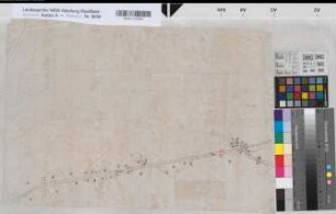
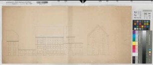
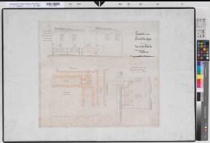
Ritterhof bei Mengede (Dortmund) Flurkarte des Gutes Ritterhof 2.H. 19.Jh. (1 : 2500) 71 x 103 Kopie Landsberg-Velen Nr. 301
- Reference number
-
W 051, 9224
- Former reference number
-
Landsberg-Velen 301
- Further information
-
Ort: Ritterhof, Dortmund
- Context
-
Karten A (Allgemein) >> 2. Land- und Forstwirtschaft >> 2.2. Katasterkarten
- Holding
-
W 051 Karten A (Allgemein)
- Indexbegriff subject
-
Gut Ritterhof, Flurkarte, 1875
- Indexentry place
-
Ritterhof, Dortmund
Ritterhof, Gut, Flurkarte, 1875
- Provenance
-
Sammlungsregistraturbildner
- Date of creation
-
1875
- Other object pages
- Delivered via
- Last update
-
30.04.2025, 2:53 PM CEST
Data provider
This object is provided by:
Landesarchiv Nordrhein-Westfalen. Abteilung Westfalen. If you have any questions about the object, please contact the data provider.
Landesarchiv Nordrhein-Westfalen. Abteilung Westfalen. If you have any questions about the object, please contact the data provider.
Object type
- Karten / Pläne
Associated
- Sammlungsregistraturbildner
Time of origin
- 1875
Other Objects (12)
Straßenführung 2.H. 19.Jh. (1 : 2500) 36 x 54 Zeichnung Landsberg-Velen Nr. 439
Ostfriesland ostfriesisches Bauernhaus Seitenansichten 2.H. 19.Jh. 140 Fuß = 46 cm 48 x 65 (kol.) Zeichnung Landsberg-Velen Nr. 331
Ostfriesland ostfriesisches Bauernhaus Grundriß 2.H. 19.Jh. 140 Fuß = 46 cm 48 x 66 (kol.) Zeichnung Landsberg-Velen Nr. 329
Ostfriesland ostfriesisches Bauernhaus Balkenlage 2.H. 19.Jh. 140 Fuß = 46 cm 47 x 65 (kol.) Zeichnung Landsberg-Velen Nr. 330

"Verordnung wegen des Fideicommisgüter in dem Hochstifte Osnabrück" - Abschrift 2.H. 19.Jh.
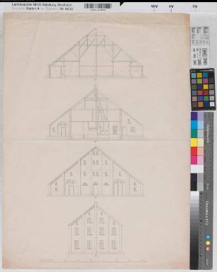
Ostfriesland ostfriesisches Bauernhaus Vorder- und Hinteransicht, Schnitte 2.H. 19.Jh. 70 Fuß = 23,1 cm 66 x 48 Zeichnung Landsberg-Velen Nr. 328
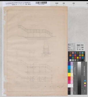
Gemen (Borken) Schloß Entwurf der Gartenbrücke Grundriß, Ansicht, Schnitte 2.H. 19.Jh. 12 Fuß = 18 cm 35 x 50 Zeichnung Landsberg-Velen Nr. 581
Gemen (Borken) Schloß Entwurf der Gartenbrücke Grundriß, Ansicht, Schnitte 2.H. 19.Jh. 12 Fuß = 18 cm 37 x 48 Zeichnung Landsberg-Velen Nr. 581
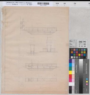
Bentlage (Rheine) Wirtschaftsgebäude Ansicht 2.H. 19.Jh. 1 : 100 21 x 33 Zeichnung Bentlage
Bentlage (Rheine) Wirtschaftsgebäude? Ansicht 2.H. 19.Jh. 1 : 100 38 x 80 Zeichnung Bentlage
Velen (Velen) Entwurf zur Dekoration der Pfarrkirche 2.H. 19.Jh. o.M. 76 x 56,5 kol. Zeichnung A. Brinkmann, Dekorationsmaler Landsberg-Velen Nr. 591a
Wocklum (Balve) Einbau eines Schwefelkiesofens in die Chemische Fabrik Grundriß, Schnitt, Ansicht 2.H. 19.Jh. 1 : 50 53 x 60 kol. Zeichnung Landsberg-Velen Nr. 95
Straßenführung 2.H. 19.Jh. (1 : 2500) 36 x 54 Zeichnung Landsberg-Velen Nr. 439
Ostfriesland ostfriesisches Bauernhaus Seitenansichten 2.H. 19.Jh. 140 Fuß = 46 cm 48 x 65 (kol.) Zeichnung Landsberg-Velen Nr. 331
Ostfriesland ostfriesisches Bauernhaus Grundriß 2.H. 19.Jh. 140 Fuß = 46 cm 48 x 66 (kol.) Zeichnung Landsberg-Velen Nr. 329
Ostfriesland ostfriesisches Bauernhaus Balkenlage 2.H. 19.Jh. 140 Fuß = 46 cm 47 x 65 (kol.) Zeichnung Landsberg-Velen Nr. 330
"Verordnung wegen des Fideicommisgüter in dem Hochstifte Osnabrück" - Abschrift 2.H. 19.Jh.
Ostfriesland ostfriesisches Bauernhaus Vorder- und Hinteransicht, Schnitte 2.H. 19.Jh. 70 Fuß = 23,1 cm 66 x 48 Zeichnung Landsberg-Velen Nr. 328
Gemen (Borken) Schloß Entwurf der Gartenbrücke Grundriß, Ansicht, Schnitte 2.H. 19.Jh. 12 Fuß = 18 cm 35 x 50 Zeichnung Landsberg-Velen Nr. 581
Gemen (Borken) Schloß Entwurf der Gartenbrücke Grundriß, Ansicht, Schnitte 2.H. 19.Jh. 12 Fuß = 18 cm 37 x 48 Zeichnung Landsberg-Velen Nr. 581
Bentlage (Rheine) Wirtschaftsgebäude Ansicht 2.H. 19.Jh. 1 : 100 21 x 33 Zeichnung Bentlage
Bentlage (Rheine) Wirtschaftsgebäude? Ansicht 2.H. 19.Jh. 1 : 100 38 x 80 Zeichnung Bentlage
Velen (Velen) Entwurf zur Dekoration der Pfarrkirche 2.H. 19.Jh. o.M. 76 x 56,5 kol. Zeichnung A. Brinkmann, Dekorationsmaler Landsberg-Velen Nr. 591a