Militärkarte
Karten und Plane zur Kriegsgeschichte von Bayern: Umgegend von Pultusk / Umgegend von Polotzk
- Alternative title
-
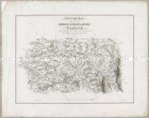
UMGEGEND VON PULTUSK / Übersicht der Kriegs Ereignisse während / der Jahre 1806 und 1807
- Location
-
Deutsches Historisches Museum, Berlin
- Inventory number
-
Do 2006/1260
- Measurements
-
Höhe x Breite: 47,5 x 60 cm (Blatt)
Höhe x Breite: 35 x 23,5 cm (Karte 1)
Höhe x Breite: 35 x 23,7 cm (Karte 2)
Höhe x Breite: 43,3 x 54,5 cm (Platte)
- Material/Technique
-
Papier, Kupferstich
- Classification
-
Kartografie (Gattung)
- Subject (what)
-
Polen
Militär
- Event
-
Herstellung
- (who)
-
Kartograf, Stecher: Franz Lau
Kartograf, Topograph, Stecher: Johann Georg Mayr
- (where)
-
München, Deutschland [historisch: Bayern, Königreich]
- (when)
-
um 1826
- Rights
-
Deutsches Historisches Museum
- Last update
-
24.03.2023, 9:28 AM CET
Data provider
This object is provided by:
Stiftung Deutsches Historisches Museum. If you have any questions about the object, please contact the data provider.
Stiftung Deutsches Historisches Museum. If you have any questions about the object, please contact the data provider.
Object type
- Militärkarte
Associated
- Kartograf, Stecher: Franz Lau
- Kartograf, Topograph, Stecher: Johann Georg Mayr
Time of origin
- um 1826
Other Objects (12)
Karten und Plane zur Kriegsgeschichte von Bayern: Uebersichts-Karte eines Theils des Kriegs Schauplatzes in Frankreich
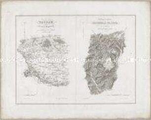
Karten und Plane zur Kriegsgeschichte von Bayern: Wagram; Die Gegend zwischen Reichenhall und Lofer

Karten und Plane zur Kriegsgeschichte von Bayern: Hanau
![540-541 [Rezension] Fangen, Ronald, ... daß sie alle eines seien](https://iiif.deutsche-digitale-bibliothek.de/image/2/e4478a6f-a4eb-4bc9-9452-b9ed6f82050c/full/!306,450/0/default.jpg)
540-541 [Rezension] Fangen, Ronald, ... daß sie alle eines seien
![602 [Rezension] Preuß, Horst Dietrich, Maria bei Luther](https://iiif.deutsche-digitale-bibliothek.de/image/2/0f228901-c04d-4d7d-8467-6af1ea57f36c/full/!306,450/0/default.jpg)
602 [Rezension] Preuß, Horst Dietrich, Maria bei Luther
![372-374 [Rezension] Rost, Hans, Das konfessionelle Schicksal Deutschlands](https://iiif.deutsche-digitale-bibliothek.de/image/2/5ced28d8-fa4c-4da7-9cea-e846e5af2f17/full/!306,450/0/default.jpg)
372-374 [Rezension] Rost, Hans, Das konfessionelle Schicksal Deutschlands
![921-922 [Rezension] Melanchthon, Philipp, Melanchthons Werke in Auswahl](https://iiif.deutsche-digitale-bibliothek.de/image/2/40319c81-1b00-455d-83bc-e772c41d0f70/full/!306,450/0/default.jpg)
921-922 [Rezension] Melanchthon, Philipp, Melanchthons Werke in Auswahl
![188-189 [Rezension] Asmussen, Hans Christian, Die Lehre vom Gottesdienst](https://iiif.deutsche-digitale-bibliothek.de/image/2/a8d7aa6c-a48e-4607-a6d0-8a819198824e/full/!306,450/0/default.jpg)
188-189 [Rezension] Asmussen, Hans Christian, Die Lehre vom Gottesdienst
![153-156 [Rezension] Leese, Kurt, Die Religion des protestantischen Menschen](https://iiif.deutsche-digitale-bibliothek.de/image/2/c435d94d-8c78-4858-9b45-3ac57eaf5532/full/!306,450/0/default.jpg)
153-156 [Rezension] Leese, Kurt, Die Religion des protestantischen Menschen
![673-674 [Rezension] Vischer, Melchior, Jan Hus](https://iiif.deutsche-digitale-bibliothek.de/image/2/1ca29c98-4c3a-4562-a59c-56bfbdeb1646/full/!306,450/0/default.jpg)
673-674 [Rezension] Vischer, Melchior, Jan Hus
![48-49 [Rezension] Der junge Luther](https://iiif.deutsche-digitale-bibliothek.de/image/2/a202c8e8-d86b-493d-9c84-ae9beb5cdba5/full/!306,450/0/default.jpg)
48-49 [Rezension] Der junge Luther
![692-693 [Rezension] Fischer, Max, Zeitgenössische Betrachtungen zur Jesuitenfrage](https://iiif.deutsche-digitale-bibliothek.de/image/2/360fe1c1-c2c0-4717-ba0a-62ca9fa5888c/full/!306,450/0/default.jpg)
692-693 [Rezension] Fischer, Max, Zeitgenössische Betrachtungen zur Jesuitenfrage
Karten und Plane zur Kriegsgeschichte von Bayern: Uebersichts-Karte eines Theils des Kriegs Schauplatzes in Frankreich
Karten und Plane zur Kriegsgeschichte von Bayern: Wagram; Die Gegend zwischen Reichenhall und Lofer
Karten und Plane zur Kriegsgeschichte von Bayern: Hanau
540-541 [Rezension] Fangen, Ronald, ... daß sie alle eines seien
602 [Rezension] Preuß, Horst Dietrich, Maria bei Luther
372-374 [Rezension] Rost, Hans, Das konfessionelle Schicksal Deutschlands
921-922 [Rezension] Melanchthon, Philipp, Melanchthons Werke in Auswahl
188-189 [Rezension] Asmussen, Hans Christian, Die Lehre vom Gottesdienst
153-156 [Rezension] Leese, Kurt, Die Religion des protestantischen Menschen
673-674 [Rezension] Vischer, Melchior, Jan Hus
48-49 [Rezension] Der junge Luther