- Reference number
-
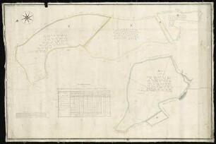
D 73, 5/1844
- Dimensions
-
Höhe: 69, Breite: 98, Maßstab: 1:5.000
- Context
-
Allgemeine Kartensammlung (bisherige Kartei) >> 23. Tit. 5 (noch nicht klassifiziert) >> 23.10. Nr. 1801 - 2000
- Holding
-
D 73 Allgemeine Kartensammlung (bisherige Kartei)
- Date of creation
-
1833
- Other object pages
- Provenance
-
Behörden, Institutionen, Einzelpersonen (Sammlungen)
- Delivered via
- Last update
-
17.09.2025, 3:09 PM CEST
Data provider
This object is provided by:
Landesarchiv Nordrhein-Westfalen. Abteilung Ostwestfalen-Lippe. If you have any questions about the object, please contact the data provider.
Landesarchiv Nordrhein-Westfalen. Abteilung Ostwestfalen-Lippe. If you have any questions about the object, please contact the data provider.
Object type
- Karten / Pläne
Time of origin
- 1833
Other Objects (12)

Brouillonkarte über die Teilung des Lipperoder Bruchs; Inselkarte mit Vermessungstabelle
Karte vom Salzuflenschen Gehölz und Gehege,. Inselkarte mit Vermessungstabelle
Teilungskarte des Lipperoder Bruchs
Karte von Lütkehölters Ankauf vom Gut Büxten (Amt Schötmar),. Inselkarte mit Vermessungstabelle
Karte von Beckmanns (Jaspers) Ankauf vom Gut Vinnen (Amt Schötmar). Inselkarte mit Vermessungstabelle
Münster Forstkarte zum Hohenlohe-Weikersheimer Münster Forst mit Vermessungstabelle. Inselkarte
Vermessungstabelle
Vermessungstabelle
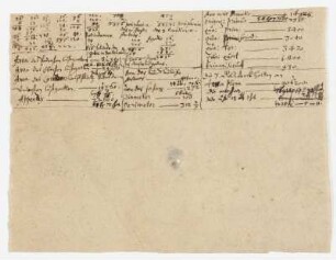
Vermessungstabelle
Karte von Steinmeiers und Litmathes Ankauf vom Gut Vinnen (Amt Schötmar). Inselkarte mit Vermessungstabelle
Karte von Bensieks Ankauf vom Gut Büxten (Amt Schötmar);. Inselkarte mit Handzeichnung, farbigVermessungstabelle
Karte von einem zur Meierei Brake gehörenden Feldstück auf dem Stuken,. Inselkarte mit Vermessungstabelle
Brouillonkarte über die Teilung des Lipperoder Bruchs; Inselkarte mit Vermessungstabelle
Karte vom Salzuflenschen Gehölz und Gehege,. Inselkarte mit Vermessungstabelle
Teilungskarte des Lipperoder Bruchs
Karte von Lütkehölters Ankauf vom Gut Büxten (Amt Schötmar),. Inselkarte mit Vermessungstabelle
Karte von Beckmanns (Jaspers) Ankauf vom Gut Vinnen (Amt Schötmar). Inselkarte mit Vermessungstabelle
Münster Forstkarte zum Hohenlohe-Weikersheimer Münster Forst mit Vermessungstabelle. Inselkarte
Vermessungstabelle
Vermessungstabelle
Vermessungstabelle
Karte von Steinmeiers und Litmathes Ankauf vom Gut Vinnen (Amt Schötmar). Inselkarte mit Vermessungstabelle
Karte von Bensieks Ankauf vom Gut Büxten (Amt Schötmar);. Inselkarte mit Handzeichnung, farbigVermessungstabelle