Sachakte
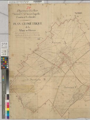
Departement de la Roer. Arrondissement d'Aix-la-Chapelle. Canton de Duren. Plan lineaire de la Mairie Düren 1:10000. Gemeinde Düren 1812 (Übersichtskarte)
- Reference number
-
BR 0148, 55
- Context
-
Regierungsbezirk Aachen: Französische Katasterkarten
- Holding
-
BR 0148 Regierungsbezirk Aachen: Französische Katasterkarten
- Provenance
-
Regierung Aachen
- Date of creation
-
1812
- Other object pages
- Delivered via
- Last update
-
30.04.2025, 2:26 PM CEST
Data provider
This object is provided by:
Landesarchiv Nordrhein-Westfalen. Abteilung Rheinland. If you have any questions about the object, please contact the data provider.
Landesarchiv Nordrhein-Westfalen. Abteilung Rheinland. If you have any questions about the object, please contact the data provider.
Object type
- Sachakte
Associated
- Regierung Aachen
Time of origin
- 1812
Other Objects (12)

Katasterkarte (vergrößerte Kopie) der Stadt Düren (Mairie de Duren Section F dite de Duren).
Departement de la Roer. Arrondissement d'Aix-la-Chapelle. Canton de Düren - Tableau d'Assemblage de la Mairie de Birkesdorf
Departement de la Roer. Arrondissement d'Aix-la-Chapelle. Canton de Düren. Plan gémériqueue de la Mairie d' Echtz (Übersichtskarte)
Arrondissement d'Aix-la-Chapelle. Canton de Düren, Mairie de Merken. Tableau d'Assemblage. 1:20000
Guide de la ville d'Aix-la-Chapelle
Departement de la Roer. Arrondissement d'Aix-la-Chapelle. Canton de Düren. Plan géométrique de la mairie de Merzenich. Terminé le 20. Octobre 1807
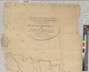
Departement de la Roer. Arrondissement d'Aix-la-Chapelle. Canton de Düren. Plan géométrique de la mairie de Merzenich. Terminé le 20. Octobre 1807
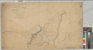
Tableau d'Assemblage du Plan cadastral parcellaire de la commune de Stockheim, Canton de Düren, Arrondissement d'Aix-la-Chapelle, Departement de la Roer (Übersichtskarte)
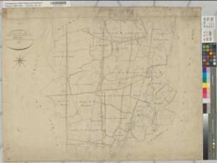
Tableau d'Assemblage du Plan cadastral parcellaire de la commune de Birgel, Canton de Düren, Arrondissement d'Aix-la-Chapelle, Departement de la Roer 1809
Le trésor de la cathédrale d'Aix-la-Chapelle
Le trésor de la cathédrale d'Aix-la-Chapelle
Der Duren-Hof in Düren; Vererbpachtung und Ablösung
Katasterkarte (vergrößerte Kopie) der Stadt Düren (Mairie de Duren Section F dite de Duren).
Departement de la Roer. Arrondissement d'Aix-la-Chapelle. Canton de Düren - Tableau d'Assemblage de la Mairie de Birkesdorf
Departement de la Roer. Arrondissement d'Aix-la-Chapelle. Canton de Düren. Plan gémériqueue de la Mairie d' Echtz (Übersichtskarte)
Arrondissement d'Aix-la-Chapelle. Canton de Düren, Mairie de Merken. Tableau d'Assemblage. 1:20000
Guide de la ville d'Aix-la-Chapelle
Departement de la Roer. Arrondissement d'Aix-la-Chapelle. Canton de Düren. Plan géométrique de la mairie de Merzenich. Terminé le 20. Octobre 1807
Departement de la Roer. Arrondissement d'Aix-la-Chapelle. Canton de Düren. Plan géométrique de la mairie de Merzenich. Terminé le 20. Octobre 1807
Tableau d'Assemblage du Plan cadastral parcellaire de la commune de Stockheim, Canton de Düren, Arrondissement d'Aix-la-Chapelle, Departement de la Roer (Übersichtskarte)
Tableau d'Assemblage du Plan cadastral parcellaire de la commune de Birgel, Canton de Düren, Arrondissement d'Aix-la-Chapelle, Departement de la Roer 1809
Le trésor de la cathédrale d'Aix-la-Chapelle
Le trésor de la cathédrale d'Aix-la-Chapelle