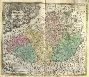
Altkarte
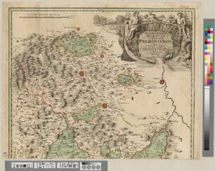
Marchionatus Moraviae Circulus Hradistiensis
Kurzbeschreibung: Karte eines Atlas
Kartographische Angaben: Maßstab in graph. Form (Milliaria Moravica) ; Nullmeridian Ferro
- Location
-
Greifswald
- Collection
-
Kartensammlung des Instituts für Geographie und Geologie (Universität Greifswald)
- Inventory number
-
AltAT/C15.00/0001-25
- Measurements
-
Maßstab [ca. 1:230.000]
- Material/Technique
-
Büttenpapier; Kupferstich, koloriert
- Inscription/Labeling
-
Verantwortlichkeitsangabe: quem Mandato Caesareo accurate emensus hac mappa delineatum exhibet Ioh. Christ. Müller S. C. M. Capitan. Editore Ioh. Baptista Homanno
- Related object and literature
- Classification
-
Kartographie
- Subject (where)
-
Norimbergae, Noribergae, Nuremberg, Nürnberg
- Event
-
Herstellung
- (when)
-
[ca. 1715]
- Last update
-
25.03.2025, 9:45 AM CET
Data provider
This object is provided by:
Universität Greifswald. Kartensammlung des Instituts für Geographie und Geologie. If you have any questions about the object, please contact the data provider.
Universität Greifswald. Kartensammlung des Instituts für Geographie und Geologie. If you have any questions about the object, please contact the data provider.
Object type
- Altkarte
Time of origin
- [ca. 1715]
Other Objects (12)
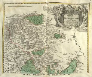
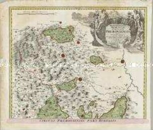
Marchionatus Moraviae Circulus Preroviensis
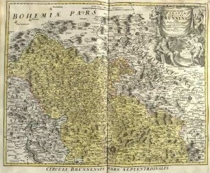
Marchionatus Moraviae Circulus Brunnensis
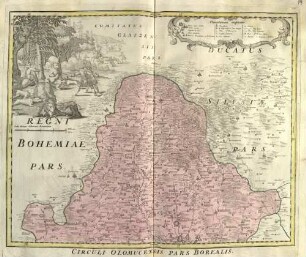
Marchionatus Moraviae Circulus Olomucensis
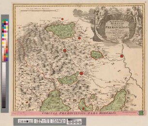
Marchionatûs Moraviae Circulus Preroviensis : Cum Privilegio Sac. Caes. Mai.
Marchionatus Moraviae Circulus Preroviensis : Cum Privilegio Sacrae Caesareae Maiestatis
Marchionatus Moraviae Circuli Znoymensis Et Iglaviensis
Marchionatus Moraviae Circulus Preroviensis

Marchionatus Moraviae Circulus Hradistiensis

Marchionatûs Moraviae Circulus Olomucensis
Marchionatus Moraviae Circulus Hradistiensis
Tabula Generalis Marchionatus Moraviae ; in sex circulos divisae quos mandato caesareo accurate emensus hac mappa delineatos exhibet Ioh. Christoph
Circulus Bavaricus
Marchionatus Moraviae Circulus Preroviensis
Marchionatus Moraviae Circulus Brunnensis
Marchionatus Moraviae Circulus Olomucensis
Marchionatûs Moraviae Circulus Preroviensis : Cum Privilegio Sac. Caes. Mai.
Marchionatus Moraviae Circulus Preroviensis : Cum Privilegio Sacrae Caesareae Maiestatis
Marchionatus Moraviae Circuli Znoymensis Et Iglaviensis
Marchionatus Moraviae Circulus Preroviensis
Marchionatus Moraviae Circulus Hradistiensis
Marchionatûs Moraviae Circulus Olomucensis
Marchionatus Moraviae Circulus Hradistiensis
Tabula Generalis Marchionatus Moraviae ; in sex circulos divisae quos mandato caesareo accurate emensus hac mappa delineatos exhibet Ioh. Christoph