
- Location
-
Forschungsbibliothek Gotha -- SPK 40.32.b C (06)
- Extent
-
6 ungezählte Blätter
- Language
-
Französisch
- Notes
-
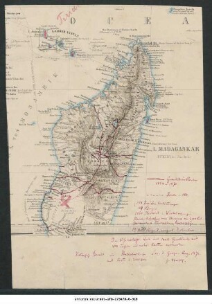
Titel fingiert nach der Systematik der Kartensammlung Konvolutmappe der Kartensammlung Perthes. - enthält Karten aus der Produktion anderer Verlage Mappe enthält neben Teilblatt 14/24 (Tananarive) einer Karte des Etat-Major du Corps d'Occupation sowie einer von Emile Gautier ausgeführten hypsometrischen und geologischen Karte der Insel auch die „Madagascar 1:500.000“ des Service géographique des colonies (Paris: Augustin Challamel; 1902) Sammlung Perthes
- Contributor
- Published
-
Gotha : Justus Perthes , 1901
- URN
-
urn:nbn:de:urmel-ufb-193878-8-18
- PURL
- Last update
-
14.04.2025, 12:54 PM CEST
Data provider
This object is provided by:
Forschungsbibliothek Gotha der Universität Erfurt. If you have any questions about the object, please contact the data provider.
Forschungsbibliothek Gotha der Universität Erfurt. If you have any questions about the object, please contact the data provider.
Object type
- Monografie
Associated
Time of origin
- Gotha : Justus Perthes , 1901
Other Objects (12)

Madagaskar und Comoren : 1904 : Kartensammlung
Madagaskar und Comoren : 1905 : Kartensammlung
Madagaskar und Comoren : 1900-1913 : Kartensammlung
Madagaskar und Comoren : 1747-1893 : Kartensammlung
Madagaskar und Comoren : 1899-1900 : Kartensammlung
Madagaskar und Comoren : 1871-1885 : Kartensammlung
Madagaskar und Comoren : 1896-1900 : Kartensammlung
Madagaskar und Comoren : 1889-1895 : Kartensammlung
Madagaskar und Comoren : 1883-1900 : Kartensammlung
Madagaskar und Comoren : 1895-1897 : Kartensammlung
Madagaskar und Comoren : 1840-1880 : Kartensammlung
Madagaskar und Comoren : 1887-1891 : Kartensammlung
Madagaskar und Comoren : 1904 : Kartensammlung
Madagaskar und Comoren : 1905 : Kartensammlung
Madagaskar und Comoren : 1900-1913 : Kartensammlung
Madagaskar und Comoren : 1747-1893 : Kartensammlung
Madagaskar und Comoren : 1899-1900 : Kartensammlung
Madagaskar und Comoren : 1871-1885 : Kartensammlung
Madagaskar und Comoren : 1896-1900 : Kartensammlung
Madagaskar und Comoren : 1889-1895 : Kartensammlung
Madagaskar und Comoren : 1883-1900 : Kartensammlung
Madagaskar und Comoren : 1895-1897 : Kartensammlung
Madagaskar und Comoren : 1840-1880 : Kartensammlung