- Location
-
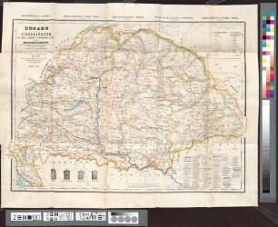
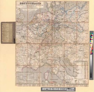
München, Bayerische Staatsbibliothek -- Mapp. XVI,22 d
- Dimensions
-
38 x 31 cm, Bildgr. 61 x 43 cm
- Extent
-
1 Kt.
- Language
-
Deutsch
- Notes
-
Lithographie
Nullmeridian: Ferro. - Mit 1 Nebenkt. d. Sprachen u. Religionen. - Maßstab in graph. Form (Polnische Stunden, Russische Werste, Deutsche geographische Meilen). - Mit Erl.
- Keyword
-
Geschichte
Straßennetz
Verwaltungsgrenze
Polen
- Event
-
Veröffentlichung
- (where)
-
München
- (who)
-
in Commission des geographischen Dépôts
- (when)
-
1831
- Contributor
- URN
-
urn:nbn:de:bvb:12-bsb00037635-8
- Last update
-
16.04.2025, 8:41 AM CEST
Data provider
This object is provided by:
Bayerische Staatsbibliothek. If you have any questions about the object, please contact the data provider.
Bayerische Staatsbibliothek. If you have any questions about the object, please contact the data provider.
Object type
- Altkarte
Associated
- Michaelis, Ernst Heinrich
- Schach, Carl
- Edler, Anton
- Selb, Josef Anton
- Wolf, ...
- in Commission des geographischen Dépôts
Time of origin
- 1831
Other Objects (12)
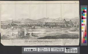
Alt- Und Neu-Stadt Kempten
Neu vermehrte Post Charte durch gantz Teutschland nach Italien, Franckreich, Niederland, Preußen, Polen, und Ungarn etc.
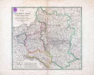
Karte von dem Königreich Polen, Großherzogthum Posen und den angrenzenden Gebieten Rußlands, Oestreichs und Preußens
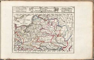
Compendiosa Poloniae Repraesentatio : Cum Gratia et Privilegio Sac. Caes. Maj. = Polen Mitt Angraentzenden Laendern

Alt Ofen

Charte von Italien Nach der dermaligen Verfassung : auch mit dessen alten und neuen Grenzen, nach den bewährtesten Hülfsmitteln neu entworfen und gezeichnet = Carta D'Italia secondo la presento Costituzione
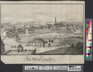
Alt-Stadt Kempten
Ungarn mit Siebenbürgen, Kroatien, Slavonien, Woywodina, Banat, und den Militairgrenzen : mit Angabe der neuen und alten politischen Eintheilungen, aller Postämter, Eisenbahnen und der Orts-Nationalitäten
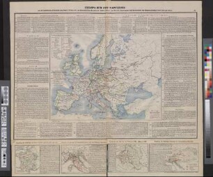
Europa Zur Zeit Napoleons : mit der historischen Uibersicht vom Jahre 1700 bis 1838, als Nebenkärtchen Frankreich, Italien, Polen (zur Zeit der Theilungen) und Oesterreich
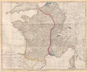
Karte von Deutschlands alten und Frankreichs neuen Grenze : von Der Natur durch Gebirge und Flüssen durch Sprachen und Sitten selbst bestimmt ; Auf den Vertrag von Verdun gegründet
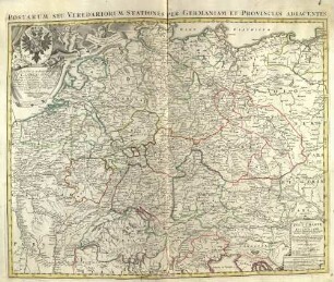
![Neu-vermehrte Post-Charte durch gantz Teutschland nach Italien, Franckreich, Niederland, Preußen, Polen und Ungarn &c. : [Gewidmet] Carolo Josepho S. R. Imp. Comiti â Paar ; Cum Privilegio Sacrae Caesareae ut et Reg. Mai. Polon. = Postarum Seu Veredariorum Stationes Per Germaniam Et Provincias Adiacentes](https://iiif.deutsche-digitale-bibliothek.de/image/2/1d87e719-423d-48f3-96f3-c4889454b06e/full/!306,450/0/default.jpg)
Neu-vermehrte Post-Charte durch gantz Teutschland nach Italien, Franckreich, Niederland, Preußen, Polen und Ungarn &c. : [Gewidmet] Carolo Josepho S. R. Imp. Comiti â Paar ; Cum Privilegio Sacrae Caesareae ut et Reg. Mai. Polon. = Postarum Seu Veredariorum Stationes Per Germaniam Et Provincias Adiacentes
Post- und Eisenbahn-Reisekarte Deutschland, Holland, Belgien, die Schweiz, Italien bis Neapel, der größte Theil von Frankreich, Ungarn, Polen etc. : Mit besonderer Rücksicht auf Eisenbahnen u. Seedampfschiffahrt
Alt- Und Neu-Stadt Kempten
Neu vermehrte Post Charte durch gantz Teutschland nach Italien, Franckreich, Niederland, Preußen, Polen, und Ungarn etc.
Karte von dem Königreich Polen, Großherzogthum Posen und den angrenzenden Gebieten Rußlands, Oestreichs und Preußens
Compendiosa Poloniae Repraesentatio : Cum Gratia et Privilegio Sac. Caes. Maj. = Polen Mitt Angraentzenden Laendern
Alt Ofen
Charte von Italien Nach der dermaligen Verfassung : auch mit dessen alten und neuen Grenzen, nach den bewährtesten Hülfsmitteln neu entworfen und gezeichnet = Carta D'Italia secondo la presento Costituzione
Alt-Stadt Kempten
Ungarn mit Siebenbürgen, Kroatien, Slavonien, Woywodina, Banat, und den Militairgrenzen : mit Angabe der neuen und alten politischen Eintheilungen, aller Postämter, Eisenbahnen und der Orts-Nationalitäten
Europa Zur Zeit Napoleons : mit der historischen Uibersicht vom Jahre 1700 bis 1838, als Nebenkärtchen Frankreich, Italien, Polen (zur Zeit der Theilungen) und Oesterreich
Karte von Deutschlands alten und Frankreichs neuen Grenze : von Der Natur durch Gebirge und Flüssen durch Sprachen und Sitten selbst bestimmt ; Auf den Vertrag von Verdun gegründet
Neu-vermehrte Post-Charte durch gantz Teutschland nach Italien, Franckreich, Niederland, Preußen, Polen und Ungarn &c. : [Gewidmet] Carolo Josepho S. R. Imp. Comiti â Paar ; Cum Privilegio Sacrae Caesareae ut et Reg. Mai. Polon. = Postarum Seu Veredariorum Stationes Per Germaniam Et Provincias Adiacentes