- Alternative title
-
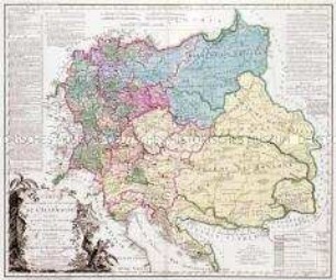
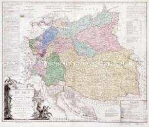
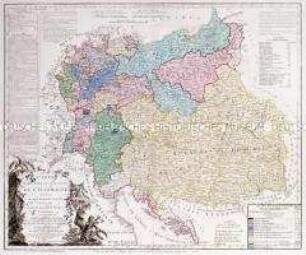
CARTE / DE / L'EMPIRE DE PERSE / Dressée
- Location
-
Deutsches Historisches Museum, Berlin
- Inventory number
-
Do 2006/898
- Measurements
-
Höhe x Breite: 55,5 x 78,5 cm (Blatt)
Höhe x Breite: 46 x 59 cm (Karte)
Höhe x Breite: 48,5 x 61,5 cm (Platte)
- Material/Technique
-
Papier, Kupferstich, grenzkoloriert
- Classification
-
Kartografie (Gattung)
- Subject (what)
-
Persien
Iran
- Event
-
Herstellung
- (who)
-
Geograph, Kartograf: Jean Baptiste Bourguignon d' Anville
Stecher, Kartograf: Paolo Santini
Kartograf, Verleger: Giuseppe Antonio Remondini
- (where)
-
Venedig, Italien
- (when)
-
um 1779
- Rights
-
Deutsches Historisches Museum
- Last update
-
24.03.2023, 9:29 AM CET
Data provider
This object is provided by:
Stiftung Deutsches Historisches Museum. If you have any questions about the object, please contact the data provider.
Stiftung Deutsches Historisches Museum. If you have any questions about the object, please contact the data provider.
Object type
- Grenzkarte
Associated
- Geograph, Kartograf: Jean Baptiste Bourguignon d' Anville
- Stecher, Kartograf: Paolo Santini
- Kartograf, Verleger: Giuseppe Antonio Remondini
Time of origin
- um 1779
Other Objects (12)
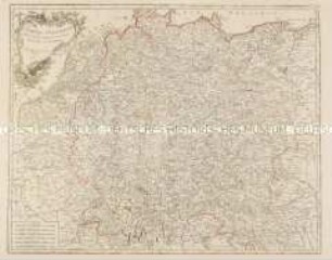
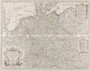
L'Empire d'Allemagne divisé en ses Cercles et ses Etats
L'Empire d'Allemagne distingué suivant l'estendüe de tous les Estats, Principautés, et Souverainetés qui passent ou qui ont passé jusque a present sous le Nom d'Allemagne
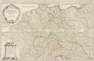
L'Empire D'Allemagne Dressée Et Dédiée A Monseigneur Le Dauphin. Par N. de Fer Géographe de sa Majesté Catholique, et de Monseigneur le Dauphin. Corigee et augmentée par Desnos Geographe a Paris rue St. Jacques au Globe 1770.
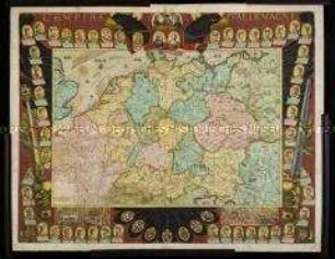
Map Of The Empire of Germany
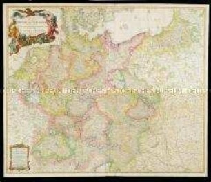
Brion et Maire: Tableau Géographique Et Politique De L'Allemagne. Blatt 1: Carte Élementaire Et Statistique De L'Allemagne, Conformément au traité de paix de Lunéville, de l'an 9 - 1801; et au recès de la diète de l'Empire, à Ratisbonne, de l'an 11 - 1803. Carte comprenant, de plus, Les Etats Autrichiens et Prussiens, hors de l'Allemagne. Par Brion et Maire, Ingénieurs-Géographes. Nouvelle édition augmentée, surtout des positions les plus signalées par la marche victorieuse et inonie des armées françaises en 1805.
Brion et Maire: Tableau Géographique Et Politique De L'Allemagne. Blatt 3: Carte Des Etats de la Confédération du Rhin. Conformément au traité de paix de Vienne, 14 Octobre 1809. Carte comprenant en entier l'Empire d' Autriche, la Confédération du Rhin, le Duché de Warsovie, au Roi de Saxe, le Royaume de Prusse; les Provinces Illyriennes et autre Etats à l'Empereur des Francais. Roi d'Italie. Par Brion et Maire, Ing. Géog. 1809. avec des changemens on 1811.
Brion et Maire: Tableau Géographique Et Politique De L'Allemagne. Blatt 2: Carte Élementaire Et Statistique De L'Allemagne, Conformément au traité de paix de Lunéville, de l'an 9 - 1801; et au recès de la diète de l'Empire, à Ratisbonne, de l'an 11 - 1803. Carte Comprenant, En Entier, La Confédération Du Rhin, Les Etats Autrichens Et Prussiens suivant le traité de Presbourg en 1805 et ceux de Tilsitt en 1807. Par BRION et MAIRE, Ingenieurs-Géographes. Nouvelle édition augmentée, surtout des positions les plus signalées par la marche victorieuse et inoure des armées françaises, et par des conventions ou traités. 1809.
Les Duchés de Cleves, de Iuliers et de Limbourg, le Comté de Meurs, le Quartier de Ruremonde dans le Duché de Guelders, l'Archevesché et Eslectorat de Cologne
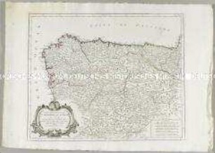
Partie Septentrionale de la Couronne de Castille

Les Etats de Savoye et de Piemont
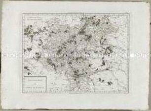
L'Allemagne dressée sur les observations de Tycho-Brahé, de Kepler, de Snellius, sur celles de Messieurs de l'Academie Royale des Sciences &c.
Atlas Nouveau: Gouvernement de l'Isle de France
L'Empire d'Allemagne divisé en ses Cercles et ses Etats
L'Empire d'Allemagne distingué suivant l'estendüe de tous les Estats, Principautés, et Souverainetés qui passent ou qui ont passé jusque a present sous le Nom d'Allemagne
L'Empire D'Allemagne Dressée Et Dédiée A Monseigneur Le Dauphin. Par N. de Fer Géographe de sa Majesté Catholique, et de Monseigneur le Dauphin. Corigee et augmentée par Desnos Geographe a Paris rue St. Jacques au Globe 1770.
Map Of The Empire of Germany
Brion et Maire: Tableau Géographique Et Politique De L'Allemagne. Blatt 1: Carte Élementaire Et Statistique De L'Allemagne, Conformément au traité de paix de Lunéville, de l'an 9 - 1801; et au recès de la diète de l'Empire, à Ratisbonne, de l'an 11 - 1803. Carte comprenant, de plus, Les Etats Autrichiens et Prussiens, hors de l'Allemagne. Par Brion et Maire, Ingénieurs-Géographes. Nouvelle édition augmentée, surtout des positions les plus signalées par la marche victorieuse et inonie des armées françaises en 1805.
Brion et Maire: Tableau Géographique Et Politique De L'Allemagne. Blatt 3: Carte Des Etats de la Confédération du Rhin. Conformément au traité de paix de Vienne, 14 Octobre 1809. Carte comprenant en entier l'Empire d' Autriche, la Confédération du Rhin, le Duché de Warsovie, au Roi de Saxe, le Royaume de Prusse; les Provinces Illyriennes et autre Etats à l'Empereur des Francais. Roi d'Italie. Par Brion et Maire, Ing. Géog. 1809. avec des changemens on 1811.
Brion et Maire: Tableau Géographique Et Politique De L'Allemagne. Blatt 2: Carte Élementaire Et Statistique De L'Allemagne, Conformément au traité de paix de Lunéville, de l'an 9 - 1801; et au recès de la diète de l'Empire, à Ratisbonne, de l'an 11 - 1803. Carte Comprenant, En Entier, La Confédération Du Rhin, Les Etats Autrichens Et Prussiens suivant le traité de Presbourg en 1805 et ceux de Tilsitt en 1807. Par BRION et MAIRE, Ingenieurs-Géographes. Nouvelle édition augmentée, surtout des positions les plus signalées par la marche victorieuse et inoure des armées françaises, et par des conventions ou traités. 1809.
Les Duchés de Cleves, de Iuliers et de Limbourg, le Comté de Meurs, le Quartier de Ruremonde dans le Duché de Guelders, l'Archevesché et Eslectorat de Cologne
Partie Septentrionale de la Couronne de Castille
Les Etats de Savoye et de Piemont
L'Allemagne dressée sur les observations de Tycho-Brahé, de Kepler, de Snellius, sur celles de Messieurs de l'Academie Royale des Sciences &c.