- Alternative title
-
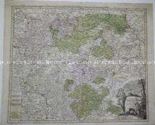
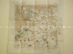
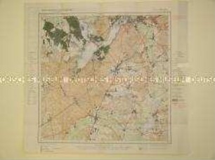
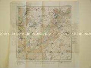
MARCHINATUS / MORAVIAE / CIRCULUS OLOMU- / CENSIS / quem / MANDATO CAESAREO / accourate emensus / hac mappa / delineatum exhibet / Io. Chr. Müller S.C.M. Cap. et Ingen. : / Editore / Ioh. Baptista Homan / Norimbergae
- Location
-
Deutsches Historisches Museum, Berlin
- Inventory number
-
1988/1784 1.-2.
- Measurements
-
Höhe x Breite: 45,8 x 57,8 cm (Karte)
Höhe x Breite: 51,2 x 62,8 cm (Blatt)
- Material/Technique
-
Karte: Druckfarbe, Papier, Kupferstich, koloriert
- Classification
-
Kartografie (Gattung)
- Subject (what)
-
Mähren
- Event
-
Herstellung
- (who)
-
Kartograf: J.Chr. Müller
Geograph, Kartograf: Johann Baptist Homann
- (where)
-
Nürnberg [historisch: Norimbergae], Deutschland [historisch: Heiliges Römisches Reich]
- (when)
-
um 1720
- Rights
-
Deutsches Historisches Museum
- Last update
- 24.03.2023, 9:27 AM CET
Data provider
This object is provided by:
Stiftung Deutsches Historisches Museum. If you have any questions about the object, please contact the data provider.
Stiftung Deutsches Historisches Museum. If you have any questions about the object, please contact the data provider.
Object type
- Regionalkarte
Associated
- Kartograf: J.Chr. Müller
- Geograph, Kartograf: Johann Baptist Homann
Time of origin
- um 1720
Other Objects (12)

Landkarte des Brünner Kreises, um 1720, in zwei Sektionen
Landkarte von Thüringen
Landkarte aus der Serie "Berlin und Umgebung", Blatt 5: Potsdam
Landkarte aus der Serie "Berlin und Umgebung", Blatt 4: Freienwalde
Landkarte aus der Serie "Berlin und Umgebung", Blatt 7: Köpenick

Landkarte aus der Serie "Berlin und Umgebung", Blatt 6: Berlin
Landkarte aus der Serie "Berlin und Umgebung", Blatt 3: Bernau
Landkarte aus der Serie "Berlin und Umgebung", Blatt 9: Werder
Landkarte aus der Serie "Berlin und Umgebung", Blatt 8: Strausberg
Karte von Ost- und Nordfriesland, um 1720
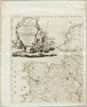
Landkarte von Irland mit einer Nebenkarte: The Sea Coasts of Great Britain and Ireland.
Karte des Rheins in 3 Sektionen
Landkarte des Brünner Kreises, um 1720, in zwei Sektionen
Landkarte von Thüringen
Landkarte aus der Serie "Berlin und Umgebung", Blatt 5: Potsdam
Landkarte aus der Serie "Berlin und Umgebung", Blatt 4: Freienwalde
Landkarte aus der Serie "Berlin und Umgebung", Blatt 7: Köpenick
Landkarte aus der Serie "Berlin und Umgebung", Blatt 6: Berlin
Landkarte aus der Serie "Berlin und Umgebung", Blatt 3: Bernau
Landkarte aus der Serie "Berlin und Umgebung", Blatt 9: Werder
Landkarte aus der Serie "Berlin und Umgebung", Blatt 8: Strausberg
Karte von Ost- und Nordfriesland, um 1720
Landkarte von Irland mit einer Nebenkarte: The Sea Coasts of Great Britain and Ireland.