- Reference number
-
5-1-18 Sammlung Vogel, Kaiserswerth, 5-1-18-3.0000
- Dimensions
-
610x510
- Formal description
-
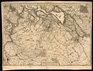
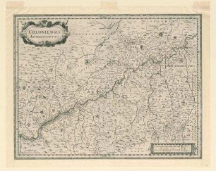
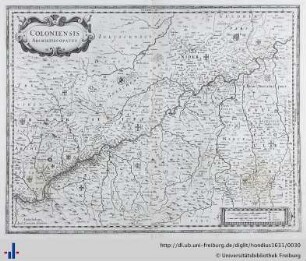
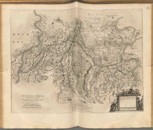
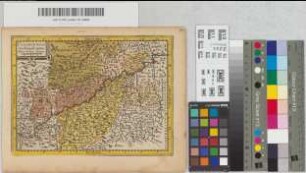
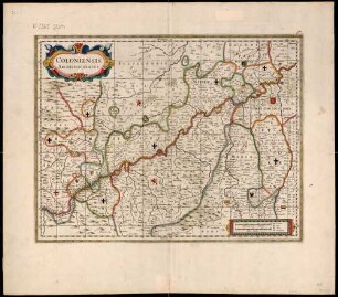
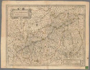
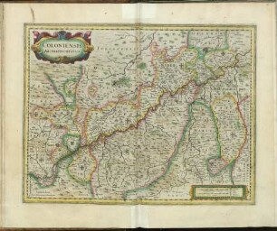
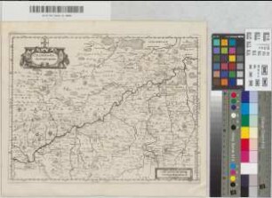
Topografische, westorientierte Karte des Erzbistums Köln; Haltern-Windeck-Koblenz-Erkelenz, darin: Keysersweerd + S. Jorgen; Aus: „Prodromus Geographicus hoc est archiepiscopatus Coloniensis“, (der erste Atlas Nordrhein-Westfalens); Rückseite: Deutscher Text: Ertz Bischthumb Cölln. Kupferstich. Maßstab: Milliaria Germanica communia
- Material
-
Papier
- Further information
-
Ausführung: farbig; Kupferstich
- Context
-
Sammlung Vogel, Kaiserswerth >> Karten und Pläne; 1. Karten
- Holding
-
5-1-18 Sammlung Vogel, Kaiserswerth Sammlung Vogel, Kaiserswerth
- Indexentry person
-
Gigante, Johann, Medico et Mathematico - Kartenzeichner
- Date of creation
-
1620
- Other object pages
- Delivered via
- Last update
-
24.06.2025, 2:18 PM CEST
Data provider
This object is provided by:
Stadtarchiv Düsseldorf. If you have any questions about the object, please contact the data provider.
Stadtarchiv Düsseldorf. If you have any questions about the object, please contact the data provider.
Object type
- Karten / Pläne
Time of origin
- 1620
Other Objects (12)

Coloniensis Archiepiscopatus (Köln, Erzbistum)
Coloniensis Archiepiscopatus [Ebtm. Köln]
Pars Septentrionalis Brabantiae
Coloniensis archiepiscopatus
Coloniensis Archiepiscopatus.
Coloniensis Archiepiscopatus
Coloniensis Archiepiscopatus
Coloniensis Archiepiscopatus
Coloniensis Archiepiscopatus
Coloniensis Archiepiscopatus
Coloniensis Archiepiscopatus
Coloniensis Archiepiscopatus
Coloniensis Archiepiscopatus (Köln, Erzbistum)
Coloniensis Archiepiscopatus [Ebtm. Köln]
Pars Septentrionalis Brabantiae
Coloniensis archiepiscopatus
Coloniensis Archiepiscopatus.
Coloniensis Archiepiscopatus
Coloniensis Archiepiscopatus
Coloniensis Archiepiscopatus
Coloniensis Archiepiscopatus
Coloniensis Archiepiscopatus
Coloniensis Archiepiscopatus